
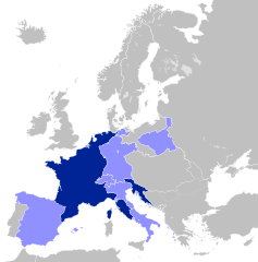
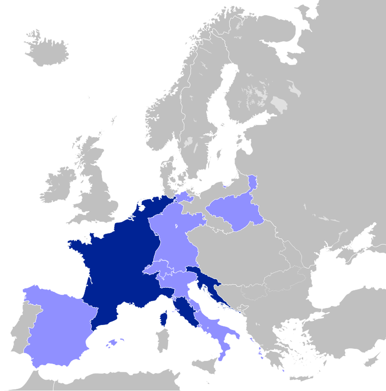
Plik:First French Empire 1812.svg

Wielkość pliku podglądu PNG dla pliku SVG: 450 × 456 pikseli Inne rozdzielczości: 237 × 240 pikseli | 474 × 480 pikseli | 758 × 768 pikseli | 1011 × 1024 pikseli | 2021 × 2048 pikseli.
Rozmiar pierwotny (Plik SVG, nominalnie 450 × 456 pikseli, rozmiar pliku: 464 KB)
| Plik First French Empire 1812.svg znajduje się w Wikimedia Commons – repozytorium wolnych zasobów. Dane z jego strony opisu znajdują się poniżej. |
Opis


.svg)
.svg)
.svg)
.svg)
.svg)


.svg)
.svg)
.svg)


.png)
.png)


.svg)


.svg)

.svg)


.svg)
.svg)
.svg)
.svg)


.svg)
.png)


.svg)


.svg)
.svg)


.svg)


.svg)


.svg)
.svg)
.svg)
.svg)
.svg)
.svg)
.svg)
.svg)
_cropped.svg)
.svg)
.svg)
.svg)
.svg)
.svg)
.svg)
.svg)
.svg)
.svg)
.svg)
.svg)
.svg)
.svg)
.svg)
.svg)
.svg)
.svg)
.svg)
.svg)
.svg)
.svg)
.svg)
.svg)
.svg)
.svg)
.svg)
.svg)
.svg)
.svg)
.svg)
.svg)
.svg)
.svg)
.svg)
.svg)
.svg)
.svg)
.svg)
.svg)
.svg)
.svg)
.svg)
.svg)
.svg)
.svg)
Licencja
Ten plik udostępniony jest na licencji Creative Commons Uznanie autorstwa – Na tych samych warunkach 3.0.
- Wolno:
- dzielić się – kopiować, rozpowszechniać, odtwarzać i wykonywać utwór
- modyfikować – tworzyć utwory zależne
- Na następujących warunkach:
- uznanie autorstwa – musisz określić autorstwo utworu, podać link do licencji, a także wskazać czy utwór został zmieniony. Możesz to zrobić w każdy rozsądny sposób, o ile nie będzie to sugerować, że licencjodawca popiera Ciebie lub Twoje użycie utworu.
- na tych samych warunkach – Jeśli zmienia się lub przekształca niniejszy utwór, lub tworzy inny na jego podstawie, można rozpowszechniać powstały w ten sposób nowy utwór tylko na podstawie tej samej lub podobnej licencji.
Oryginalny rejestr przesyłania
This image is a derivative work of the following images:
- File:Blank_map_of_Europe.svg licensed with Cc-by-sa-2.5
- 2011-09-19T22:57:58Z Alphathon 680x520 (603759 Bytes) Added North/Northern Cyprus
- 2011-08-23T10:26:48Z Heb 680x520 (604212 Bytes) Added [[:en:Bornholm]] (taken from [[:File:Denmark blank map.svg]])
- 2011-04-12T00:40:40Z Alphathon 680x520 (602549 Bytes) Upgraded Sicily based on "File:Freeworldmaps-sicily.jpg". Upgraded Malta based on "File:Map of Malta 2.png". Simplified Croatian borders.
- 2011-04-10T21:43:04Z Alphathon 680x520 (607359 Bytes) Upgraded Croatia, Bosnia & Herzegovina, Slovenia and surrounding countries based on data from "File:Kroatien - Politische Gliederung (Karte).png"
- 2011-04-10T20:05:09Z Alphathon 680x520 (568373 Bytes) Improved Serbia, Montenegro and surrounding countries using data from "File:Serbia Map.png". Fixed Serbia-Montenegro border. Added Kosovo (using dashed border, since it is not a universally recognised nation, and left the lan
- 2011-04-10T15:55:02Z Alphathon 680x520 (524980 Bytes) Tweaked Ukraine and surrounding countries based on data from "File:Up-map.png"
- 2011-04-10T04:02:09Z Alphathon 680x520 (511168 Bytes) Improved Greece, Albania, F.Y.R. Macedonia and Bulgaria based on "File:Greece topo.jpg"
- 2011-04-10T02:48:52Z Alphathon 680x520 (505569 Bytes) Tweaked Germany and surrounding countries based on info from "File:Germany_general_map.png"
- 2011-04-10T01:54:05Z Alphathon 680x520 (493733 Bytes) Converted all lakes back to separate layer. Added Finish lakes and tweaked Finland shape based on "File:Finland 1996 CIA map.jpg". Added Swiss lakes based on "File:Suisse cantons.svg". Tweaked Scotland and added Lochs.
- 2011-04-10T00:07:54Z Alphathon 680x520 (450120 Bytes) Improved England outline and added Isle of Wight based on "File:England Regions - Blank.svg". Improved Denmark based on "File:2 digit postcode danmark.png". Improved Sweden based on "File:Map of Sweden, CIA, 1996.jpg"
- 2011-04-08T15:53:07Z Alphathon 680x520 (438878 Bytes) Upgraded/fixed various parts of the map. Details: *Some minor fixes to Ireland and added some of the larger lakes based on [[:File:Ireland_trad_counties_named.svg]] *Pretty major fixes to Scotland (mainly the west coast and i
- 2008-09-17T09:50:25Z F7 680x520 (531491 Bytes)
- 2008-09-17T09:42:57Z F7 680x520 (2353 Bytes)
- 2008-05-26T19:04:07Z Collard 680x520 (531491 Bytes) uploading on behalf of [[User:Checkit]], direct complaints to him plox: 'Moved countries out of the "outlines" group, removed "outlines" style class, remove separate style information for Russia'
- 2008-04-30T01:38:52Z TimothyBourke 680x520 (531767 Bytes) Changed the country code of Serbia to RS per [http://en.wikipedia.org/wiki/Serbian_country_codes] and the file [http://www.iso.org/iso/iso3166_en_code_lists.txt].
- 2008-02-08T22:44:37Z CarolSpears 680x520 (531767 Bytes) validated
- 2007-07-10T11:47:59Z MrWeeble 680x520 (533112 Bytes) Updated to include British Crown Dependencies as seperate entities and regroup them as "British Islands", with some simplifications to the XML and CSS
- 2007-05-14T17:17:34Z Zirland 680x520 (540659 Bytes) serbia and montenegro
- 2007-03-30T20:40:49Z W!B: 680x520 (538830 Bytes) minor corr: update nl:Ijsselmeer, del fi:lakes (all small), add ru:lake Oneka (all ref maps.google), glued northern irland back to ie ;)
- 2007-02-05T18:44:32Z Maix 680x520 (538295 Bytes) cropped
- 2007-02-04T15:07:29Z Maix 680x520 (538310 Bytes) {{Information |Description=A blank Map of Europe in SVG format. Every country has an id which is its ISO-3116-1-ALPHA2 code in lower case for easy coloring. |Source=Image based on [[Image:Europe_countries.svg|]] by [[User:Ti
Uploaded with derivativeFX
Historia pliku
Kliknij na datę/czas, aby zobaczyć, jak plik wyglądał w tym czasie.
| Data i czas | Miniatura | Wymiary | Użytkownik | Opis | |
|---|---|---|---|---|---|
| aktualny | 20:29, 30 lip 2012 | | 450 × 456 (464 KB) | Alphathon | Prinicpalities |
| 02:14, 25 kwi 2012 |  | 450 × 456 (462 KB) | Alphathon | Naming of objects | |
| 01:50, 25 kwi 2012 |  | 450 × 456 (462 KB) | Alphathon | Added the Septinsular Republic. | |
| 03:53, 21 lut 2012 |  | 450 × 456 (459 KB) | Alphathon | +Semi-autonomous Ottoman states | |
| 23:10, 19 lut 2012 |  | 450 × 456 (437 KB) | Alphathon | Fixed Portugal | |
| 23:06, 19 lut 2012 |  | 450 × 456 (437 KB) | Alphathon | == {{int:filedesc}} == {{Information |Description=A map of the First French Empire in 1812. |Source={{Derived from|Blank_map_of_Europe.svg|display=50}} |Date=2012-02-19 21:04 (UTC) |Author=*File:Blank_map_of_Europe.svg: maix<sup>[[User |
Lokalne wykorzystanie pliku
Następujące strony korzystają z tego pliku:
- Królestwo Etrurii
- Królestwo Holandii
- Królestwo Neapolu
- Królestwo Westfalii
- Królestwo Włoch (1805–1814)
- Księstwo Bergu
- Księstwo Kurlandii, Semigalii i Piltynia
- Księstwo Leyen
- Księstwo Warszawskie
- Prowincje Iliryjskie
- Republika Alby (1796–1801)
- Republika Ankony
- Republika Batawska
- Republika Bergamo
- Republika Bolońska
- Republika Bouillonu
- Republika Cisalpińska
- Republika Cispadańska
- Republika Cisreńska
- Republika Connaught
- Republika Cremy
- Republika Helwecka
- Republika Liguryjska
- Republika Partenopejska
- Republika Rodańska
- Republika Rzymska (XVIII wiek)
- Republika Subalpejska
- Republika Transpadańska
- Republika Tyberyńska
- Republika Włoska (1802–1805)
- Vaud
- Wielkie Księstwo Bergu
- Wielkie Księstwo Frankfurtu
- Wielkie Księstwo Würzburga
- Wolne Miasto Gdańsk (1807–1814)
- Związek Reński
- Szablon:Kraje zależne od Francji 1792–1815
Globalne wykorzystanie pliku
Ten plik jest wykorzystywany także w innych projektach wiki:
- Wykorzystanie na ar.wikipedia.org
- الحروب النابليونية
- جمهورية لكة
- مملكة نابولي
- مملكة بافاريا
- مملكة ساكسونيا
- مملكة فورتمبيرغ
- دوقية تسكانة الكبرى
- الجمهورية الألبية
- فتسلار
- دوقية بينيفينتو
- دوقية ماسا وكرارا
- اتحاد الراين
- مملكة إيطاليا النابوليونية
- جمهورية إيطاليا النابوليونية
- جمهورية شقيقة
- الجمهورية الرومانية (القرن 18)
- الجمهورية الليغورية
- دوقية بيرغ الكبرى
- مملكة فستفالن
- دوقية بادن الكبرى
- الجمهورية البارثينوبية
- دوقية هسن الكبرى
- إمارة ريغنسبورغ
- دوقية فورتسبورغ الكبرى
- دوقية فرانكفورت الكبرى
- إمارة زالم
- إمارة لاين
- الجمهورية الباتافية
- المملكة الهولندية
- جمهورية ألبا
- جمهورية لياج
- قالب:دول عميلة في الثورة الفرنسية وحروب نابليون
- مملكة إسبانيا النابليونية
- دوقية وارسو
- مدينة دانزيغ الحرة النابليونية
- سويسرا في العهد النابليوني
- الثورة الأيرلندية 1798
- مملكة إتروريا
- أقاليم إيليرية
- الجمهورية الهيلفيتية
- Wykorzystanie na ast.wikipedia.org
- Wykorzystanie na bg.wikipedia.org
- Wykorzystanie na ca.wikipedia.org
Pokaż listę globalnego wykorzystania tego pliku.