
Plik:Aksai Chin Sino-Indian border map.png

Rozmiar pierwotny (624 × 872 pikseli, rozmiar pliku: 102 KB, typ MIME: image/png)
| Plik Aksai Chin Sino-Indian border map.png znajduje się w Wikimedia Commons – repozytorium wolnych zasobów. Dane z jego strony opisu znajdują się poniżej. |
Opis

|
Ta ilustracja ma także wersję wektorową („SVG”).
Zaleca się wykorzystywanie w galeriach dostępnej wersji wektorowej zamiast obecnej. File:Aksai Chin Sino-Indian border map.png → File:Aksai Chin Sino-Indian border map.svg
Więcej o grafice wektorowej przeczytasz w artykule Przenoszenie grafik Commons do formatu SVG. Dostępna jest także informacja o obsłudze grafik SVG przez MediaWiki. |
 |
| Opis |
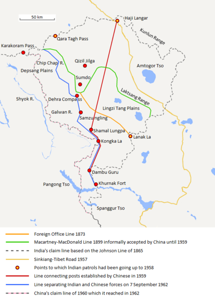
English: The map shows the Indian and Chinese claims of the border in the Aksai Chin region, the Macartney-MacDonald line, the Foreign Office Line, as well as the progress of Chinese forces as they occupied areas during the Sino-Indian War. |
| Data | |
| Źródło | Praca własna |
| Autor | The Discoverer |
The Macartney-MacDonald line is described as follows: "From the Karakoram Pass the crests of the range run nearly east for about half a degree, and then turn south to a little below the 35th parallel.. Rounding... the source of the Karakash, the line of hills to be followed runs north-east to a point east of Kizil Jilga and from there, in a south-easterly direction, follows the Lak Tsung (Lokzhung) Range until that meets a spur.. which has hitherto been shown on our maps as the eastern boundary of Ladakh.[1]
The Macartney-MacDonald line was never accepted by China, although they informally indicated acceptance on certain occasions:
- Woodman, Dorothy (1969) Himalayan Frontiers: A Political Review of British, Chinese, Indian, and Russian Rivalries, Praeger, s. 102 „The proposed boundary seems never to have been considered in the same form again until Alastair Lamb revived it in 1964.”
- Lamb, Alastair (1965). "Treaties, Maps and the Western Sector of the Sino-Indian Boundary Dispute". The Australian Year Book of International Law. "Unfortunately, the Chinese never replied formally to the note, though they indicated informally on a number of occasions their agreement as to its boundary alignment."
In 1959, Chou confirmed the new Chinese claim line to Nehru.
References: [2] archive copy at the Wayback Machine [3] [4] [5] [6] Map on last page archive copy at the Wayback Machine [7]
![[2]](http://cpasindia.org/images/sino-india1.jpg)
![[3]](http://www.frontline.in/static/html/fl2018/images/20030912002104801.jpg)
![[4]](http://www.frontline.in/static/html/fl2018/images/20030912002104802.jpg)
![[5]](http://www.frontline.in/static/html/fl2320/images/20061020001608505.jpg)
![[6]](http://www.indiandefencereview.com/wp-content/uploads/2013/06/Aksai-Chin-GOI-Map.jpg)
Licencja
- Wolno:
- dzielić się – kopiować, rozpowszechniać, odtwarzać i wykonywać utwór
- modyfikować – tworzyć utwory zależne
- Na następujących warunkach:
- uznanie autorstwa – musisz określić autorstwo utworu, podać link do licencji, a także wskazać czy utwór został zmieniony. Możesz to zrobić w każdy rozsądny sposób, o ile nie będzie to sugerować, że licencjodawca popiera Ciebie lub Twoje użycie utworu.
- na tych samych warunkach – Jeśli zmienia się lub przekształca niniejszy utwór, lub tworzy inny na jego podstawie, można rozpowszechniać powstały w ten sposób nowy utwór tylko na podstawie tej samej lub podobnej licencji.
Historia pliku
Kliknij na datę/czas, aby zobaczyć, jak plik wyglądał w tym czasie.
| Data i czas | Miniatura | Wymiary | Użytkownik | Opis | |
|---|---|---|---|---|---|
| aktualny | 22:06, 7 wrz 2020 | | 624 × 872 (102 KB) | The Discoverer | Removed Tibet-Sinkiang boundary, added label for Amtogor Tso. |
| 04:51, 9 cze 2020 |  | 624 × 872 (102 KB) | MarkH21 | Intended change from the last edit (i.e. latest version with "informally" per references in talk discussion) | |
| 04:29, 9 cze 2020 |  | 624 × 872 (101 KB) | MarkH21 | Reverted to version as of 00:21, 7 February 2018 (UTC) This was the previous version; the addition of “accepted by China until 1959” was the contested change, not the revert to the original description (the refs are also now dead, but previously said tacit acceptance which isn’t outright acceptance) | |
| 21:37, 23 kwi 2018 |  | 624 × 872 (102 KB) | The Discoverer | Reverted to version as of 09:10, 13 December 2017 (UTC) The file of 12 December removes a statement that is supported by the source. As per COM:OVERWRITE, "Controversial or contested changes should be uploaded to a separate filename" | |
| 02:21, 7 lut 2018 |  | 624 × 872 (101 KB) | 樂號 | Reverted to version as of 23:05, 12 December 2017 (UTC) | |
| 11:10, 13 gru 2017 |  | 624 × 872 (102 KB) | The Discoverer | Reverted to version as of 11:07, 19 February 2017 (UTC) The file of 12 December removes a statement that is supported by the source. As per COM:OVERWRITE, "Controversial or contested changes should be uploaded to a separate filename" | |
| 01:05, 13 gru 2017 |  | 624 × 872 (101 KB) | 樂號 | Macartney–MacDonald Line is only proposed by Britain No official accept made by China | |
| 13:07, 19 lut 2017 |  | 624 × 872 (102 KB) | The Discoverer | Added Karakoram Pass and Kunlun Range | |
| 17:26, 1 kwi 2015 |  | 624 × 872 (59 KB) | RokerHRO | optipng -o7 -i0 → 40.77% decrease | |
| 17:00, 2 paź 2014 |  | 624 × 872 (99 KB) | The Discoverer | Uploaded correct file with scale added. |
Lokalne wykorzystanie pliku
Poniższa strona korzysta z tego pliku:
Globalne wykorzystanie pliku
Ten plik jest wykorzystywany także w innych projektach wiki:
- Wykorzystanie na ar.wikipedia.org
- Wykorzystanie na ast.wikipedia.org
- Wykorzystanie na as.wikipedia.org
- Wykorzystanie na az.wikipedia.org
- Wykorzystanie na bh.wikipedia.org
- Wykorzystanie na bn.wikipedia.org
- Wykorzystanie na ca.wikipedia.org
- Wykorzystanie na de.wikipedia.org
- Wykorzystanie na en.wikipedia.org
- Wykorzystanie na es.wikipedia.org
- Wykorzystanie na fr.wikipedia.org
- Wykorzystanie na hi.wikipedia.org
- Wykorzystanie na id.wikipedia.org
- Wykorzystanie na it.wikipedia.org
- Wykorzystanie na ja.wikipedia.org
- Wykorzystanie na ka.wikipedia.org
- Wykorzystanie na kn.wikipedia.org
- Wykorzystanie na ko.wikipedia.org
- Wykorzystanie na lv.wikipedia.org
- Wykorzystanie na ml.wikipedia.org
- Wykorzystanie na ms.wikipedia.org
- Wykorzystanie na nl.wikipedia.org
- Wykorzystanie na no.wikipedia.org
- Wykorzystanie na or.wikipedia.org
- Wykorzystanie na pt.wikipedia.org
- Wykorzystanie na ro.wikipedia.org
- Wykorzystanie na ru.wikipedia.org
- Wykorzystanie na ru.wikinews.org
- Wykorzystanie na sr.wikipedia.org
- Wykorzystanie na ta.wikipedia.org
- Wykorzystanie na te.wikipedia.org
- Wykorzystanie na uk.wikipedia.org
- Wykorzystanie na vi.wikipedia.org
Pokaż listę globalnego wykorzystania tego pliku.