
Plik:NintokuTomb.jpg

Rozmiar podglądu – 600 × 600 pikseli. Inne rozdzielczości: 240 × 240 pikseli | 480 × 480 pikseli | 769 × 768 pikseli | 1025 × 1024 pikseli | 1345 × 1344 pikseli.
Rozmiar pierwotny (1345 × 1344 pikseli, rozmiar pliku: 2,38 MB, typ MIME: image/jpeg)
| Plik NintokuTomb.jpg znajduje się w Wikimedia Commons – repozytorium wolnych zasobów. Dane z jego strony opisu znajdują się poniżej. |
| Opis |
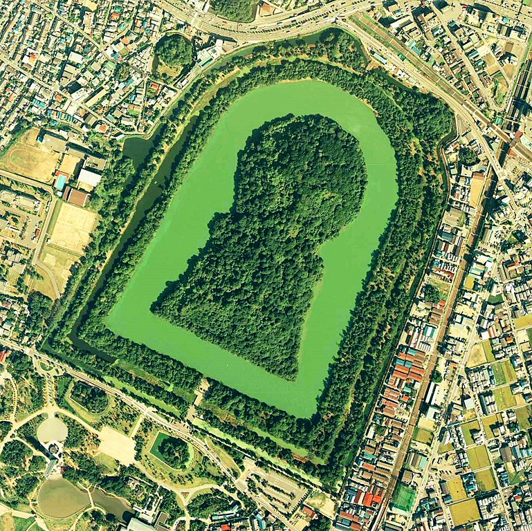
Daisen-kofun in Sakai, Osaka, Japan. This is one of the largest tombs in the world. Japanese government regards this as the tomb of Emperor Nintoku, the 16th emperor, but many historians don't think so. The keyhole-like tomb is 486m long, 305m wide at the bottom and 245m in diameter. English: Daisen-Kofun, the tomb of Emperor Nintoku, Osaka
Español: El Daisen-Kofun, tumba legendaria de Emperador Nintoku
Suomi: Kofun-kauden hautakumpu Osakassa, yksi maailman suurimmista. |
| Data | |
| Źródło | http://w3land.mlit.go.jp/cgi-bin/WebGIS2/WC_AirPhoto.cgi?IT=p&DT=n&PFN=CKK-85-2&PCN=C2&IDX=8 |
| Autor | Ministry of Land, Infrastructure and Transport Government of Japan & moja resized |
| Licencja (Ponowne użycie tego pliku) |
GFDL |
| Pozycja fotografa | | To i inne zdjęcia na: OpenStreetMap |
|---|
- 仁徳天皇陵とされる古墳
- ソース
- 整理番号:CKK852-C2-8
- 撮影:1985年(昭和60年)

|
Właściciel autorskich praw majątkowych do tego pliku, the Ministry of Land, Infrastructure, Transport and Tourism of Japan, zezwala każdemu wykorzystać go w dowolnym celu, pod warunkiem, że wykorzystujący wyraźnie wskaże autora. Redystrybucja, wykonywanie prac pochodnych, użycie komercyjne oraz każde inne są dozwolone. |
Uznanie autorstwa:
Copyright © National Land Image Information (Color Aerial Photographs), Ministry of Land, Infrastructure, Transport and Tourism
|
 |
This image is copyrighted by the Ministry of Land, Infrastructure, Transport and Tourism of Japan. For terms of use, see the stipulation to use of National Land Information (in Japanese) and message from MLIT (in Japanese and English). When you display this image on an article, include the following phrase in the description: "Made based on National Land Image Information (Color Aerial Photographs), Ministry of Land, Infrastructure, Transport and Tourism".
|
Historia pliku
Kliknij na datę/czas, aby zobaczyć, jak plik wyglądał w tym czasie.
| Data i czas | Miniatura | Wymiary | Użytkownik | Opis | |
|---|---|---|---|---|---|
| aktualny | 11:19, 7 cze 2020 | | 1345 × 1344 (2,38 MB) | 名古屋太郎 | 明るさ等変更 |
| 22:44, 17 sie 2005 |  | 800 × 800 (515 KB) | Moja~commonswiki | {{Information| |Description=Daisen-kofun in Sakai, Osaka, Japan. This is one of the largest tombs in the world. Japanese gorvernment regards this as the tomb of Emperor Nintoku, the 16th emperor, but many historians doubt don't think so. The keyhole-lik |
Lokalne wykorzystanie pliku
Żadna strona nie korzysta z tego pliku.
Globalne wykorzystanie pliku
Ten plik jest wykorzystywany także w innych projektach wiki:
- Wykorzystanie na en.wikipedia.org
- Wykorzystanie na fr.wikipedia.org
- Wykorzystanie na ja.wikipedia.org
- Wykorzystanie na www.wikidata.org
- Wykorzystanie na zh.wikipedia.org