
Plik:Ptolemaeus Magna Germania.jpg
Rozmiar podglądu – 800 × 575 pikseli. Inne rozdzielczości: 320 × 230 pikseli | 640 × 460 pikseli | 1024 × 736 pikseli | 1280 × 920 pikseli | 2560 × 1840 pikseli | 5440 × 3909 pikseli.
Rozmiar pierwotny (5440 × 3909 pikseli, rozmiar pliku: 27,13 MB, typ MIME: image/jpeg)
| Plik Ptolemaeus Magna Germania.jpg znajduje się w Wikimedia Commons – repozytorium wolnych zasobów. Dane z jego strony opisu znajdują się poniżej. |
Opis
| Opis |
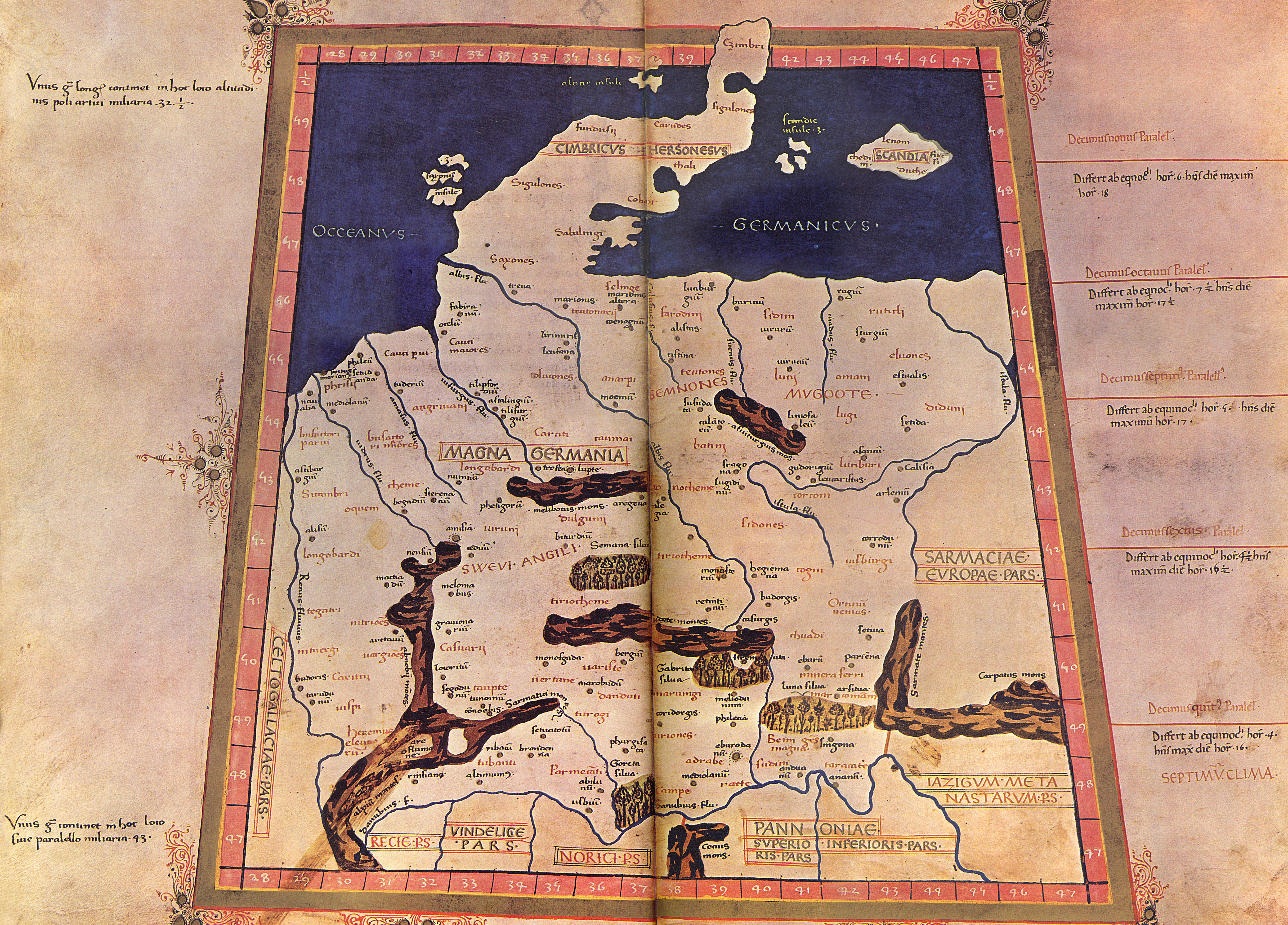
English: The 4th Map of Europe from Ptolemy's Geography, depicting Germany. - The Codex Latinus V. F. 32 is a manuscript edition of Ptolemy's Geography held by the National Library at Naples, Italy. It was photographed for publication in Cosmographia, intro. by Lelio Pagani and photog. by Domenico Lucchetti, in 1975 and 1990. - This is the only map of this Codex currently held in Commons.
Deutsch: EVROPA TABVLA QVARTA – Quarta Europe Tabula continet Germaniam cum insulis sibi adiacentibus. Die Karte zu Magna Germania aus der im Original griechisch verfaßten Geographike Hyphegesis des in Alexandria wirkenden Claudius Ptolemäus (*um 100; † um 175). Spätmittelalterliche Kopie des 15. Jahrhunderts die unter dem Titel Cosmographia erschien. Ptolemäus soll zwischen 125 und 151 tätig gewesen sein. Viele Wissenschaftler gehen davon aus, daß das Kartenwerk entweder vollständig oder zumindest teilweise in späterer Zeit auf der Grundlage des ptolemäischen Textes rekonstruiert worden ist. Der Codex Latinus V F.32 liegt in der Nationalbibliothek Neapel. Das Kartenwerk wird dem in Italien tätigen Deutschen Nicolaus Germanus zugeschrieben. |
||||||||||||||||
| Data | 15. Jahrhundert/31. Oktober 2009 | ||||||||||||||||
| Źródło | Praca własna | ||||||||||||||||
| Autor |
|
||||||||||||||||
| Inne wersje |
  |
||||||||||||||||
Licencja
|
Autor tej pracy zmarł w 1490 roku, więc ten materiał przeszedł do domeny publicznej w kraju pochodzenia, jak również w państwach i terytoriach, gdzie prawo autorskie wygasa w ciągu 100 lat po śmierci autora. Powyższa praca jest własnością publiczną w Stanach Zjednoczonych, ponieważ została opublikowana (lub zarejestrowana w U.S. Copyright Office) przed 1 stycznia 1929. | |
| Plik rozpoznano jako wolny od znanych ograniczeń praw autorskich, włącznie z prawami zależnymi i pokrewnymi. | |
Historia pliku
Kliknij na datę/czas, aby zobaczyć, jak plik wyglądał w tym czasie.
| Data i czas | Miniatura | Wymiary | Użytkownik | Opis | |
|---|---|---|---|---|---|
| aktualny | 23:20, 31 paź 2009 | | 5440 × 3909 (27,13 MB) | Mediatus | {{Information |Description={{de|1=EVROPA TABVLA QVARTA – Quarta Europe Tabula continet Germaniam cum insulis sibi adiacentibus. Die Karte zu ''Magna Germania'' aus der im Original griechisch verfaßten ''Geographike Hyphegesis'' des in Alexandria wirke |
Lokalne wykorzystanie pliku
Następujące strony korzystają z tego pliku:
Globalne wykorzystanie pliku
Ten plik jest wykorzystywany także w innych projektach wiki:
- Wykorzystanie na als.wikipedia.org
- Wykorzystanie na ast.wikipedia.org
- Wykorzystanie na bg.wikipedia.org
- Wykorzystanie na br.wikipedia.org
- Wykorzystanie na ca.wikipedia.org
- Wykorzystanie na cs.wikipedia.org
- Wykorzystanie na da.wikipedia.org
- Wykorzystanie na da.wikibooks.org
- Wykorzystanie na de.wikipedia.org
- Artaunon
- Kalisia
- Arae Flaviae
- Germania magna
- Oppidum auf dem Staffelberg
- Leuphana
- Benutzer:Drekamu/Notizen
- Amisia
- Portal Diskussion:Mecklenburg-Vorpommern/Archiv/1
- Treva
- Viadrus
- Benutzer:Mediatus/Bilder
- Gauonarion
- Sousoudata
- Tarodunum
- Wikipedia:WikiProjekt Germanen/Toponymie
- Bikourgion
- Alisus
- Kandounon
- Tropaia Drousou
- Luppia
- Mersouion
- Aregelia
- Loupfourdon
- Karrodounon
- Wikipedia:WikiProjekt Germanen/Projekt
- Segodounon
- Alcimoennis
- Wikipedia:WikiProjekt Germanen
- Rougion
- Siatoutanda
- Fabiranum
- Tekelia
- Lirimeris
- Marionis
- Marionis altera
- Kenennon
- Mounition
- Lakibourgion
- Aitouia
- Ouirition
Pokaż listę globalnego wykorzystania tego pliku.