
Plik:Twin Cities Metro Area (13 County).png

Rozmiar podglądu – 775 × 600 pikseli. Inne rozdzielczości: 310 × 240 pikseli | 620 × 480 pikseli | 992 × 768 pikseli | 1280 × 991 pikseli | 1500 × 1161 pikseli.
Rozmiar pierwotny (1500 × 1161 pikseli, rozmiar pliku: 866 KB, typ MIME: image/png)
| Plik Twin Cities Metro Area (13 County).png znajduje się w Wikimedia Commons – repozytorium wolnych zasobów. Dane z jego strony opisu znajdują się poniżej. |
.png)
Opis
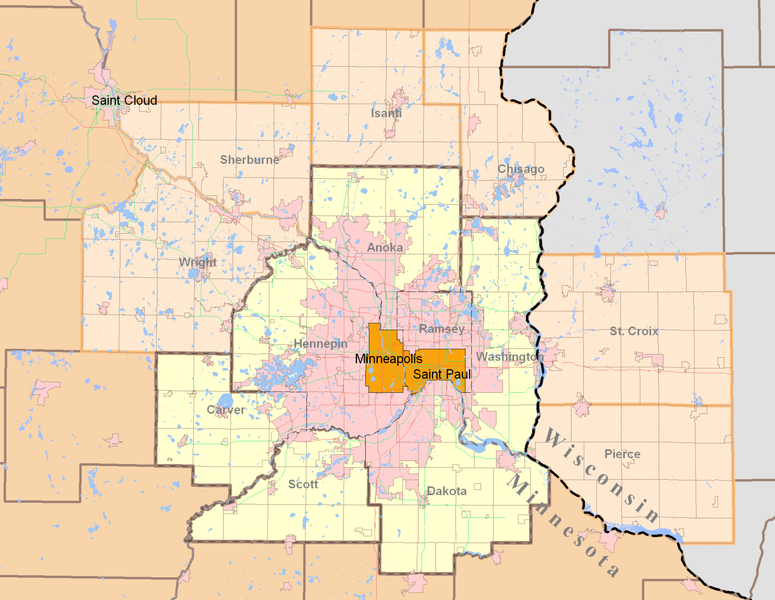
| Opis | Minneapolis-Saint Paul (Twin Cities) highlighting both the 7-county Urban Area (traditional) and the revised 13-county Metropolitan Statistical Area from the 2000 Census. Today, the term Twin Cities typically refers to the metropolitan area. The pink areas represent urbanized areas as defined by the Metropolitan Council (urbanized meaning developed with sewer access and includes suburbia and small towns). The red and green lines are highways while the grid-like lines within the counties are township boundaries and mostly rural. Suburban cities are also defined within the pink area however they are not as apparent since their borders so regularly match up with existing highways and natural features. |
| Data | |
| Źródło | Own work by uploader using publicly and freely available cartographic data by state and private agencies. Raster by MapInfo, purchased for personal use and distributed for no monetary gain. |
| Autor | Davumaya |
| Licencja (Ponowne użycie tego pliku) |
Agencies providing this data and myself make no assertion that this data is an accurate representation or legally defined. It is provided as a fair representation and should not be used for legal purposes. |
Licencja
Ja, właściciel praw autorskich do tego dzieła, udostępniam je na poniższej licencji
Ten plik udostępniony jest na licencji Creative Commons Uznanie autorstwa – Na tych samych warunkach 3.0.
- Wolno:
- dzielić się – kopiować, rozpowszechniać, odtwarzać i wykonywać utwór
- modyfikować – tworzyć utwory zależne
- Na następujących warunkach:
- uznanie autorstwa – musisz określić autorstwo utworu, podać link do licencji, a także wskazać czy utwór został zmieniony. Możesz to zrobić w każdy rozsądny sposób, o ile nie będzie to sugerować, że licencjodawca popiera Ciebie lub Twoje użycie utworu.
- na tych samych warunkach – Jeśli zmienia się lub przekształca niniejszy utwór, lub tworzy inny na jego podstawie, można rozpowszechniać powstały w ten sposób nowy utwór tylko na podstawie tej samej lub podobnej licencji.
Historia pliku
Kliknij na datę/czas, aby zobaczyć, jak plik wyglądał w tym czasie.
| Data i czas | Miniatura | Wymiary | Użytkownik | Opis | |
|---|---|---|---|---|---|
| aktualny | 23:27, 12 sie 2008 | | 1500 × 1161 (866 KB) | Davumaya | {{Information |Description= |Source= |Date= |Author= |Permission= |other_versions= }} <!--{{ImageUpload|basic}}--> |
| 23:22, 12 sie 2008 |  | 2000 × 1545 (238 KB) | Davumaya | {{Information |Description=Minneapolis-Saint Paul (Twin Cities) highlighting both the 7-county Urban Area (traditional) and the revised 13-county Metropolitan Statistical Area from the 2000 Census. |Source=Own work by uploader using publicly and freely a |
Lokalne wykorzystanie pliku
Poniższa strona korzysta z tego pliku:
Globalne wykorzystanie pliku
Ten plik jest wykorzystywany także w innych projektach wiki:
- Wykorzystanie na de.wikipedia.org
- Wykorzystanie na en.wikipedia.org
- Wykorzystanie na fi.wikipedia.org
- Wykorzystanie na ja.wikipedia.org
- Wykorzystanie na nl.wikipedia.org
- Wykorzystanie na ro.wikipedia.org
- Wykorzystanie na simple.wikipedia.org
- Wykorzystanie na sv.wikipedia.org
- Wykorzystanie na vi.wikipedia.org
.png)