
Plik:World in 2000 BC.svg

Wielkość pliku podglądu PNG dla pliku SVG: 800 × 397 pikseli Inne rozdzielczości: 320 × 159 pikseli | 640 × 318 pikseli | 1024 × 508 pikseli | 1280 × 635 pikseli | 2560 × 1271 pikseli | 4500 × 2234 pikseli.
Rozmiar pierwotny (Plik SVG, nominalnie 4500 × 2234 pikseli, rozmiar pliku: 847 KB)
| Plik World in 2000 BC.svg znajduje się w Wikimedia Commons – repozytorium wolnych zasobów. Dane z jego strony opisu znajdują się poniżej. |
Edit it
Opis
| Opis |
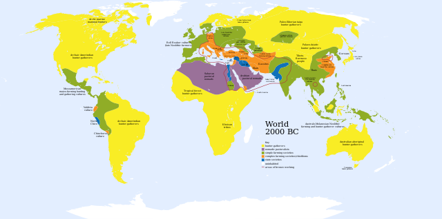
English: A map of the world, circa 2000 BC
Ελληνικά: Πολιτισμοί το 2000 π.Χ.
Français : Une carte du monde aux environs de 2000 av. J.-C. |
| Data | |
| Źródło | Based on Image:World_2000_BCE.png by User:Briangotts |
| Autor | User:Mr.absurd |
| Inne wersje |
 in Greek in Greek |
| SVG rozwój | Kod źródłowy tego poprawny. This diagram is translated using SVG switch elements: all translations are stored in the same file. |
| Maps of world history | |
| BC | |
|
| |
| AD |
1 · 50 · 100 · 200 · 250 · 300 · 400 · 500 · 700 · 750 · 820 · 900 · 1200 · 1500 · 1556 · 1648 · 1700 · 1750 · 1815 · 1859 · 1871 · 1914 · 1935 · 1989 · 2000 · |
|
Maps of colonization history | |
|
see also: Eastern Hemisphere only maps template (1300BC-1500AD) | |
| (this template: · view · discuss ) | |
.jpg)
._LOC_2001620596.jpg)
Key
uninhabited
- Red outline indicates areas of bronze working, c. 2000 BCE.
Licencja
| Ja, właściciel praw autorskich do tej pracy, udostępniam ją jako własność publiczną. Dotyczy to całego świata. W niektórych krajach może nie być to prawnie możliwe, jeśli tak, to: Zapewniam każdemu prawo do użycia tej pracy w dowolnym celu, bez żadnych ograniczeń, chyba że te ograniczenia są wymagane przez prawo. |
Historia pliku
Kliknij na datę/czas, aby zobaczyć, jak plik wyglądał w tym czasie.
| Data i czas | Miniatura | Wymiary | Użytkownik | Opis | |
|---|---|---|---|---|---|
| aktualny | 03:36, 30 lis 2023 | | 4500 × 2234 (847 KB) | Blkgardner | Reverted to version as of 09:55, 24 January 2022 (UTC) Punt's location is disputed, and it wasn't a "state society" |
| 14:31, 28 wrz 2023 |  | 4500 × 2234 (876 KB) | Notradeuussrs | added Punt | |
| 11:55, 24 sty 2022 |  | 4500 × 2234 (847 KB) | Scratchinghead | Reverted to version as of 12:48, 3 May 2018 (UTC) | |
| 17:00, 3 maj 2018 |  | 4500 × 2234 (862 KB) | LeBret | Greek translation added (from World 2000 BC EL.svg author: George Tsiagalakis | |
| 14:48, 3 maj 2018 |  | 4500 × 2234 (847 KB) | LeBret | 1) fix the civilisation of Indus valley (it's a state society, not nomadic pastoralists, as we can see in the original png file) 2) SVG is now multi-lingual (french translation added) | |
| 19:43, 20 mar 2009 |  | 4500 × 2234 (814 KB) | Huhsunqu | Norte Chico | |
| 05:31, 23 paź 2007 |  | 4500 × 2234 (813 KB) | Mr. Absurd | == Summary == {{Information |Description=A map of the world, circa 2000 BC |Source=Based on Image:World_2000_BCE.png by User:Briangotts |Date=October 22, 2007 |Author=User:Mr.absurd |Permission= |other_versions= }} | |
| 05:13, 23 paź 2007 |  | 4500 × 2234 (1,46 MB) | Mr. Absurd | == Summary == {{Information |Description=A map of the world, circa 2000 BC |Source=Based on Image:World_2000_BCE.png by User:Briangotts |Date=October 22, 2007 |Author=User:Mr.absurd |Permission= |other_versions= }} [[Category:SVG_maps_of_th | |
| 04:51, 23 paź 2007 |  | 4500 × 2234 (1,45 MB) | Mr. Absurd | == Summary == {{Information |Description=A map of the world, circa 2000 BC |Source=Based on Image:World_2000_BCE.png by User:Briangotts |Date=October 22, 2007 |Author=User:Mr.absurd |Permission= |other_versions= }} | |
| 04:25, 23 paź 2007 |  | 5365 × 2796 (1,27 MB) | Mr. Absurd | {{Information |Description=A map of the world, circa 2000 BC |Source=Based on Image:World_2000_BCE.png by User:Briangotts |Date=October 22, 2007 |Author=User:Mr.absurd |Permission= |other_versions= }} |
Lokalne wykorzystanie pliku
Poniższa strona korzysta z tego pliku:
Globalne wykorzystanie pliku
Ten plik jest wykorzystywany także w innych projektach wiki:
- Wykorzystanie na ar.wikipedia.org
- Wykorzystanie na ary.wikipedia.org
- Wykorzystanie na de.wikipedia.org
- Wykorzystanie na el.wikipedia.org
- Wykorzystanie na en.wikipedia.org
- Wykorzystanie na fr.wikipedia.org
- Wykorzystanie na he.wikipedia.org
- Wykorzystanie na hu.wikipedia.org
- Wykorzystanie na io.wikipedia.org
- Wykorzystanie na it.wikipedia.org
- Wykorzystanie na li.wikipedia.org
- Wykorzystanie na ml.wikipedia.org
- Wykorzystanie na no.wikipedia.org
- Wykorzystanie na oc.wikipedia.org
- Wykorzystanie na pt.wikipedia.org
- Wykorzystanie na ru.wikipedia.org
- Wykorzystanie na sv.wikipedia.org
- Wykorzystanie na sw.wikipedia.org
- Wykorzystanie na uk.wikipedia.org
- Wykorzystanie na zh.wikipedia.org