
Plik:Miners Needle from Bluff Spring Trail, Superstition Wilderness.jpg

Rozmiar pierwotny (3648 × 2736 pikseli, rozmiar pliku: 2,3 MB, typ MIME: image/jpeg)
| Plik Miners Needle from Bluff Spring Trail, Superstition Wilderness.jpg znajduje się w Wikimedia Commons – repozytorium wolnych zasobów. Dane z jego strony opisu znajdują się poniżej. |
Opis
| Opis |
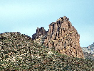
English: This is the view looking northeast at Miner's Needle from the Bluff Spring Trail. This area figures prominently in the legends of gold in the Supes. The Lost Dutchman's Mine is thought to be near here.
I hiked the Charleyboy Duece Loop - the hike shown as Charlebois Loop II in "Hiker's Guide to the Superstition Wilderness" by Jack Stewart and Liz Carlson. From Wikipedia: "The Superstition Mountains, popularly referred to as "The Superstitions" or "The Supes", are a range of mountains in Arizona located to the east of the Phoenix metropolitan area. They are anchored by Superstition Mountain, a large mountain that is a popular recreation destination for residents of the Phoenix, Arizona area. The mountain range is in the federally-designated Superstition Wilderness Area, and includes a variety of natural features in addition to the mountain that is its namesake. Weaver's Needle, a prominent landmark and rock climbing destination set behind and to the east of Superstition Mountain, is a tall erosional remnant [1] that plays a significant role in the legend of the Lost Dutchman's Gold Mine. Peralta Canyon, on the northeast side of Superstition Mountain, contains a popular trail that leads up to Freemont Saddle, which provides a very picturesque view of Weaver's Needle. Miner's Needle is another prominent formation in the wilderness and a popular hiking destination." |
| Data | |
| Źródło |
Miner's Needle from Bluff Spring Trail - Superstition Wilderness
|
| Autor | Alan English CPA from Scottsdale, Arizona 85254, USA |
| Pozycja fotografa | | To i inne zdjęcia na: OpenStreetMap |
|---|
Licencja
- Wolno:
- dzielić się – kopiować, rozpowszechniać, odtwarzać i wykonywać utwór
- modyfikować – tworzyć utwory zależne
- Na następujących warunkach:
- uznanie autorstwa – musisz określić autorstwo utworu, podać link do licencji, a także wskazać czy utwór został zmieniony. Możesz to zrobić w każdy rozsądny sposób, o ile nie będzie to sugerować, że licencjodawca popiera Ciebie lub Twoje użycie utworu.
- na tych samych warunkach – Jeśli zmienia się lub przekształca niniejszy utwór, lub tworzy inny na jego podstawie, można rozpowszechniać powstały w ten sposób nowy utwór tylko na podstawie tej samej lub podobnej licencji.
| Ten plik, opublikowany pierwotnie w serwisie Flickr, został przejrzany February 19, 2011 przez administratora lub zaufanego użytkownika File Upload Bot (Magnus Manske), który stwierdził, że jest on dostępny w serwisie Flickr pod powyższą licencją. |
Historia pliku
Kliknij na datę/czas, aby zobaczyć, jak plik wyglądał w tym czasie.
| Data i czas | Miniatura | Wymiary | Użytkownik | Opis | |
|---|---|---|---|---|---|
| aktualny | 01:06, 20 lut 2011 | | 3648 × 2736 (2,3 MB) | File Upload Bot (Magnus Manske) | {{Information |Description=This is the view looking northeast at Miner's Needle from the Bluff Spring Trail. This area figures prominently in the legends of gold in the Supes. The Lost Dutchman's Mine is thought to be near here. I hiked the Charleyboy |
Lokalne wykorzystanie pliku
Poniższa strona korzysta z tego pliku:
Globalne wykorzystanie pliku
Ten plik jest wykorzystywany także w innych projektach wiki:
- Wykorzystanie na de.wikipedia.org
- Wykorzystanie na en.wikipedia.org
- Wykorzystanie na ja.wikipedia.org
- Wykorzystanie na nl.wikipedia.org
- Wykorzystanie na www.wikidata.org