
Plik:Abbasid Caliphate 891-892.png

Rozmiar podglądu – 800 × 382 pikseli. Inne rozdzielczości: 320 × 153 pikseli | 640 × 306 pikseli | 1024 × 490 pikseli | 1280 × 612 pikseli | 3054 × 1460 pikseli.
Rozmiar pierwotny (3054 × 1460 pikseli, rozmiar pliku: 1,44 MB, typ MIME: image/png)
| Plik Abbasid Caliphate 891-892.png znajduje się w Wikimedia Commons – repozytorium wolnych zasobów. Dane z jego strony opisu znajdują się poniżej. |
Opis
| Opis |
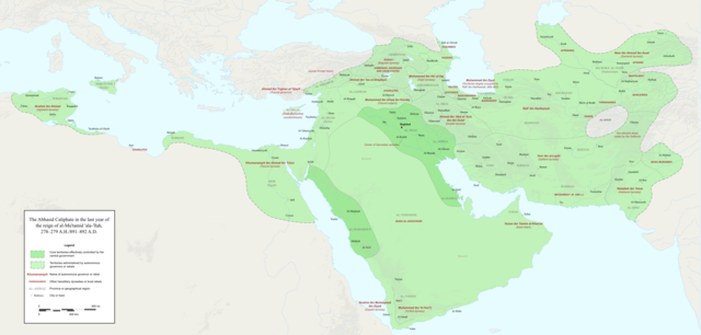
English: Map of the Abbasid Caliphate at the end of the reign of al-Mu'tamid in 891-892. Dark green denotes provinces under the effective control of the central government; light green denotes provinces under the control of autonomous governors or rebels.
The core Abbasid territories include Shahrazur, Darabadh, al-Samaghan, Hulwan, Masabadhan, Mihrijanqadhaq, the Euphrates districts, and Qarqisiyya (al-Tabari v. 37, p. 98; Bianquis p. 96). Map originally created as an .SVG file in Inkscape and converted to .PNG for size reasons. Background topography taken from DEMIS Mapserver, which are public domain. Works Cited:
|
| Data | |
| Źródło | Praca własna |
| Autor | Ro4444 |
| Inne wersje |
 |
Licencja
Ja, właściciel praw autorskich do tego dzieła, udostępniam je na poniższej licencji
Ten plik udostępniony jest na licencji Creative Commons Uznanie autorstwa – Na tych samych warunkach 4.0 Międzynarodowe.
- Wolno:
- dzielić się – kopiować, rozpowszechniać, odtwarzać i wykonywać utwór
- modyfikować – tworzyć utwory zależne
- Na następujących warunkach:
- uznanie autorstwa – musisz określić autorstwo utworu, podać link do licencji, a także wskazać czy utwór został zmieniony. Możesz to zrobić w każdy rozsądny sposób, o ile nie będzie to sugerować, że licencjodawca popiera Ciebie lub Twoje użycie utworu.
- na tych samych warunkach – Jeśli zmienia się lub przekształca niniejszy utwór, lub tworzy inny na jego podstawie, można rozpowszechniać powstały w ten sposób nowy utwór tylko na podstawie tej samej lub podobnej licencji.
Historia pliku
Kliknij na datę/czas, aby zobaczyć, jak plik wyglądał w tym czasie.
| Data i czas | Miniatura | Wymiary | Użytkownik | Opis | |
|---|---|---|---|---|---|
| aktualny | 01:18, 4 gru 2017 | | 3054 × 1460 (1,44 MB) | Ro4444 | Further color corrections |
| 00:50, 4 gru 2017 |  | 3054 × 1460 (1,44 MB) | Ro4444 | Color correction | |
| 23:11, 3 gru 2017 |  | 3054 × 1460 (1,44 MB) | Ro4444 | User created page with UploadWizard |
Lokalne wykorzystanie pliku
Żadna strona nie korzysta z tego pliku.
Globalne wykorzystanie pliku
Ten plik jest wykorzystywany także w innych projektach wiki:
- Wykorzystanie na ar.wikipedia.org
- Wykorzystanie na de.wikiversity.org
- Wykorzystanie na en.wikipedia.org
- Wykorzystanie na en.wikibooks.org
- Wykorzystanie na et.wikipedia.org
- Wykorzystanie na fa.wikipedia.org
- Wykorzystanie na hy.wikipedia.org
- Wykorzystanie na id.wikipedia.org
- Wykorzystanie na ja.wikipedia.org
- Wykorzystanie na no.wikipedia.org
- Wykorzystanie na pt.wikipedia.org
- Wykorzystanie na sco.wikipedia.org
- Wykorzystanie na uk.wikipedia.org
- Wykorzystanie na uz.wikipedia.org
- Wykorzystanie na zh.wikipedia.org