Przejdź do zawartości

Plik:1755 Bellin Map of the Great Lakes - Geographicus - GreatLakes-bellin-1755.jpg

Treść strony nie jest dostępna w innych językach.
Ten plik jest umieszczony w Wikimedia Commons
Z Wikipedii, wolnej encyklopedii

Rozmiar pierwotny(4000 × 3215 pikseli, rozmiar pliku: 3,49 MB, typ MIME: image/jpeg)

Jacques-Nicolas Bellin: Partie Occidentale de la Nouvelle France ou du Canada.   (Wikidata search (Cirrus search) Wikidata query (SPARQL)  Create new Wikidata item based on this file)
Artysta
Jacques-Nicolas Bellin  (1703–1772)  wikidata:Q607846 s:fr:Auteur:Jacques-Nicolas Bellin
 
Inne nazwiska i pseudonimy
Jacques Nicolas, Sieur Bellin; Jacques Nicolas Bellin; Nicolas Bellin
Opis francuski kartograf, encyklopedyści, geograf i hydrograf
Data urodzenia/śmierci 1703 Edytuj to na Wikidanych 21 marca 1772 Edytuj to na Wikidanych
Miejsce urodzenia/śmierci Paryż Wersal
Wykaz autorytatywny
artist QS:P170,Q607846
Tytuł
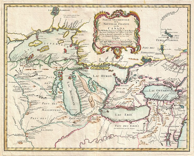
Partie Occidentale de la Nouvelle France ou du Canada.
Opis
English: A rare and extremely influential 1755 map of the Great Lakes drawn by Jacques Nicolas Bellin. This map, which appeared in the 1755 issue of the Homann Heirs Atlas Major, covers all five of the Great Lakes as well as the adjacent Indian lands and the English colonies of Pennsylvania, New Jersey and New York. Cartographically this map offers a number of important innovations and is largely derived from Bellin’s very similar map of 1745. The plate was acquired and reissued by Homann Heirs in 1755 in response to European interest in the French and Indian War which started one year prior in 1754. Bellin based this map on the most advanced French cartographic intelligence available at the time. Heidenrich and Dahl consider this map to constitute “the first new material pertaining to New France to appear since the maps of Guillaume de L'Isle three decades earlier. Most notably this map incorporates the work of the French fur trader and explorer Sieur la Verendrye and the explorer-missionary Father Pierre de Charlevoix. From Verendrye, Bellin is able to extract a significantly advanced view, over De L’Isle, of the form of the Great Lakes and their client river systems. He also relies on Verendrye’s journals with regard to the placement of numerous Indian nations and villages. Charlevoix is generally regarded as Bellin’s source for his curious choice to include several fictional islands in Lake Superior, including I. Philippeaux, I. Pontchartrain, and I. St. Anne. This map is the first, though hardly the last, to depict these ghost islands which baffled explorers until the early 19th century. A quick overview of this map will reveal a territory that is very much dominated by various American Indian nations though nominally under a tenuous French hegemony. The vast lands of the Miami, the Iroquois, the Erie, the Huron, the Renard, the Mascouten, and the Illinois overwhelm tiny bastions of French power in the form of various forts and missions. Among these are Fort Frontenac, Fort Niagara, Mission Francois Xavier, and the fledgling “R. et Port de Checagou,” the future site of Chicago. The French, without the vast colonial resources of the English and Spanish, relied heavily on alliance with, rather than outright control of, indigenous populations. Thus it is understandable why the American Indian nations of this region were quick to throw their lot in with the French against the domineering English during the French and Indian War. In the lower right hand quadrants of this map Bellin employs a common cartographic trick to flatter his royal patrons in Paris. By diminishing the proportional size of the English colonial holdings in Pennsylvania, New Jersey, Virginia and New York, Bellin, at least metaphorically, advances the supremacy of the French dominions in North America. In addition to its advanced mapping of the Great Lakes, its introduction of the ghost islands of Lake Superior, and its incorporation of the most recent explorations in the region, this map enjoys lasting significance due to John Mitchell’s use of it in compiling his important wall map, A Map of the British & French Dominions in North America. Mitchell’s monumental cartographic masterpiece was used in 1783 to define the boundaries between Canada and the post-Revolutionary United States, forming the basis for national borders that are still in effect today.
Data 1755 (dated)
Rozmiar wysokość: 17,5 cali (44,4 cm); szerokość: 21,5 cali (54,6 cm)
dimensions QS:P2048,17.5U218593
dimensions QS:P2049,21.5U218593
Numer inwentarzowy
Geographicus link: GreatLakes-bellin-1755
Źródło/Fotograf

Atlas Homannianus Mathematic-Historice Delineatus, (Homann Heirs, Nuremberg), 1755.

Licencja
(Ponowne użycie tego pliku)
Plik jest wierną reprodukcją fotograficzną dwuwymiarowego utworu, znajdującego się w domenie publicznej z następującego powodu:
Public domain

Ten materiał przeszedł do domeny publicznej w kraju pochodzenia, jak również w państwach i terytoriach, gdzie prawo autorskie wygasa w ciągu 100 lat po śmierci autora.


You must also include a United States public domain tag to indicate why this work is in the public domain in the United States.
Zgodnie z oficjalnym oświadczeniem Wikimedia Foundation wierne reprodukcje dwuwymiarowych utworów z domeny publicznej są w domenie publicznej, zajmowanie przeciwnego stanowiska godzi w samą ideę domeny publicznej (więcej w: Commons:When to use the PD-Art tag).
Niniejsza reprodukcja jest więc również własnością publiczną. Użytkowanie tego dzieła może być zabronione lub ograniczane przez miejscowe prawo na obszarze jego jurysdykcji; patrz: Commons:Reuse of PD-Art photographs.

Podpisy

Dodaj jednolinijkowe objaśnienie tego, co ten plik pokazuje

Obiekty przedstawione na tym zdjęciu

przedstawia

image/jpeg

77e3e62eb9d4211797932f8b002ed36d64c800a7

3 659 720 bajt

3215 piksel

4000 piksel

Historia pliku

Kliknij na datę/czas, aby zobaczyć, jak plik wyglądał w tym czasie.

Data i czasMiniaturaWymiaryUżytkownikOpis
aktualny01:49, 25 mar 2011Miniatura wersji z 01:49, 25 mar 20114000 × 3215 (3,49 MB)BotMultichillT{{subst:User:Multichill/Geographicus |link=http://www.geographicus.com/P/AntiqueMap/GreatLakes-bellin-1755 |product_name=1755 Bellin Map of the Great Lakes |map_title=Partie Occidentale de la Nouvelle France ou du Canada. |description=A rare and extremely

Poniższa strona korzysta z tego pliku:

Globalne wykorzystanie pliku