
Plik:Antarctic profile hg.png

Rozmiar podglądu – 800 × 574 pikseli. Inne rozdzielczości: 320 × 230 pikseli | 640 × 460 pikseli | 1024 × 735 pikseli | 1078 × 774 pikseli.
Rozmiar pierwotny (1078 × 774 pikseli, rozmiar pliku: 191 KB, typ MIME: image/png)
| Plik Antarctic profile hg.png znajduje się w Wikimedia Commons – repozytorium wolnych zasobów. Dane z jego strony opisu znajdują się poniżej. |
| Opis |
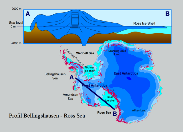
Profile through the Antarctic ice sheet (A) Bellingshausen Sea - West Antarctic ice sheet - Ross ice shelf - Ross Sea (B). The profile shows that most of the West Antarctic ice sheet is grounded below sea level which makes it sensitive to sea level rise. If the contact of the ice to the bottom rocks is lost seaward of the grounding line, the ice sheet becomes significantly thinner (some 100 m), forming a shelf ice.
|
| Data | |
| Źródło | Praca własna |
| Autor | Hannes Grobe 21:51, 12 August 2006 (UTC), Alfred Wegener Institute for Polar and Marine Research, Bremerhaven, Germany |
| Licencja (Ponowne użycie tego pliku) |
Own work, share alike, attribution required (Creative Commons CC-BY-SA-2.5) |
Ja, właściciel praw autorskich do tego dzieła, udostępniam je na poniższej licencji
Ten plik udostępniony jest na licencji Creative Commons Uznanie autorstwa – Na tych samych warunkach 2.5.
- Wolno:
- dzielić się – kopiować, rozpowszechniać, odtwarzać i wykonywać utwór
- modyfikować – tworzyć utwory zależne
- Na następujących warunkach:
- uznanie autorstwa – musisz określić autorstwo utworu, podać link do licencji, a także wskazać czy utwór został zmieniony. Możesz to zrobić w każdy rozsądny sposób, o ile nie będzie to sugerować, że licencjodawca popiera Ciebie lub Twoje użycie utworu.
- na tych samych warunkach – Jeśli zmienia się lub przekształca niniejszy utwór, lub tworzy inny na jego podstawie, można rozpowszechniać powstały w ten sposób nowy utwór tylko na podstawie tej samej lub podobnej licencji.
Historia pliku
Kliknij na datę/czas, aby zobaczyć, jak plik wyglądał w tym czasie.
| Data i czas | Miniatura | Wymiary | Użytkownik | Opis | |
|---|---|---|---|---|---|
| aktualny | 16:39, 22 lis 2023 | | 1078 × 774 (191 KB) | Rémih | Cropped 7 % horizontally, 4 % vertically using CropTool with precise mode. |
| 23:51, 12 sie 2006 |  | 1155 × 806 (198 KB) | Hgrobe | {{Information| |Description=Profile through the Antarctic ice sheet from the Ross Sea - Ross ice shelf - West Antarctic ice sheet - Bellingshausen Sea |Source=own work |Date=2006-08-08 |Author=~~~~ |Permission=Own work, share alike, attribution required ( |
Lokalne wykorzystanie pliku
Poniższa strona korzysta z tego pliku:
Globalne wykorzystanie pliku
Ten plik jest wykorzystywany także w innych projektach wiki:
- Wykorzystanie na ceb.wikipedia.org
- Wykorzystanie na el.wikipedia.org
- Wykorzystanie na en.wikipedia.org
- Wykorzystanie na es.wikipedia.org
- Wykorzystanie na fr.wikipedia.org
- Wykorzystanie na hu.wikipedia.org
- Wykorzystanie na nl.wikipedia.org
- Wykorzystanie na nn.wikipedia.org
- Wykorzystanie na ru.wikipedia.org
- Wykorzystanie na uk.wikipedia.org
- Wykorzystanie na www.wikidata.org