
Plik:Deepwater Horizon oil spill - May 24, 2010.jpg

Rozmiar pierwotny (2118 × 1628 pikseli, rozmiar pliku: 369 KB, typ MIME: image/jpeg)
| Plik Deepwater Horizon oil spill - May 24, 2010.jpg znajduje się w Wikimedia Commons – repozytorium wolnych zasobów. Dane z jego strony opisu znajdują się poniżej. |
Opis
| Opis |
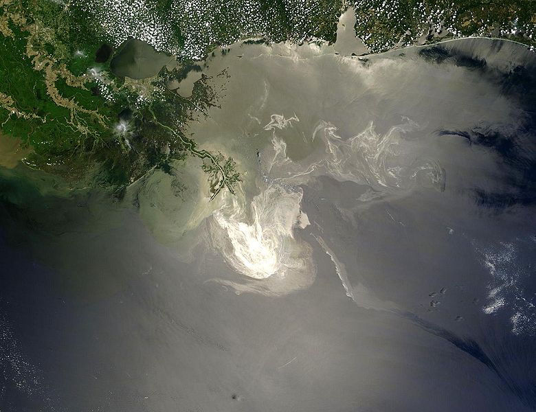
English: Description from NASA (source):
"NASA's Terra Satellites Sees Spill on May 24
Français : Traduction partielle de la description par la NASA(source): La marée noire causée par l'incendie de la plateforme pétrolière Deepwater Horizon vue par le satellite Terra, de la NASA, le 24 mai 2010.
Cette image a été acquise par le Moderate-Resolution Imaging Spectroradiometer (MODIS, pour Spectroradiomètre d'imagerie à résolution moyenne), embarqué sur le satellite Terra. Le pétrole lisse la surface de l'océan, ce qui la rend plus claire là où elle réfléchit le soleil (par exemple, au centre de la photo) et plus sombre ailleurs (par exemple en bas à droite). Le delta du Mississippi est visible en haut, entouré d'eaux saumâtres et boueuses qui apparaissent en brun, rayé de rubans argentés de pétrole. |
| Data | |
| Źródło | Original image, here cropped on left and at top |
| Autor | NASA/GSFC, MODIS Rapid Response |
| Inne wersje |
|

|

Licencja
| Ten plik jest w domenie publicznej ponieważ został stworzony przez NASA. Polityka praw autorskich NASA stwierdza, że „materiały NASA nie są chronione prawami autorskimi, chyba że zapisano inaczej”. (NASA copyright policy lub JPL Image Use Policy). | ||
 |
Uwaga:
|
Historia pliku
Kliknij na datę/czas, aby zobaczyć, jak plik wyglądał w tym czasie.
| Data i czas | Miniatura | Wymiary | Użytkownik | Opis | |
|---|---|---|---|---|---|
| aktualny | 07:26, 26 maj 2010 | | 2118 × 1628 (369 KB) | APK | == Summary == {{Information |Description={{en|"Sunlight illuminated the lingering oil slick off the Mississippi Delta on May 24, 2010. The Moderate Resolution Imaging Spectroradiometer (MODIS) on NASA’s Terra satellit |
Lokalne wykorzystanie pliku
Poniższa strona korzysta z tego pliku:
Globalne wykorzystanie pliku
Ten plik jest wykorzystywany także w innych projektach wiki:
- Wykorzystanie na af.wikipedia.org
- Wykorzystanie na be.wikipedia.org
- Wykorzystanie na ca.wikipedia.org
- Wykorzystanie na cs.wikipedia.org
- Wykorzystanie na da.wikipedia.org
- Wykorzystanie na de.wikipedia.org
- Wykorzystanie na el.wikipedia.org
- Wykorzystanie na en.wikipedia.org
- Marine conservation
- Portal:Marine life
- Wikipedia:Featured pictures/Space/Looking back
- Wikipedia:Featured picture candidates/delist/2010
- Wikipedia:Featured pictures thumbs/23
- Wikipedia:Featured picture candidates/June-2010
- Wikipedia:ITN archives/2010/May
- Talk:Deepwater Horizon oil spill/Archive 4
- Wikipedia:Featured picture candidates/Deepwater Horizon oil spill - May 24, 2010.jpg
- Wikipedia:Wikipedia Signpost/2010-06-28/Features and admins
- User talk:APK/Archive 22
- Wikipedia:Featured picture candidates/delist/Deepwater oil spill 5-24-10
- Talk:Deepwater Horizon oil spill/Archive 10
- Wikipedia:Picture of the day/April 2012
- Template:POTD/2012-04-20
- Wikipedia:Main Page history/2012 April 20
- User talk:APK/Archive 25
- Research and Development Institute of Ecology and the Sustainable Use of Natural Resources
- Wikipedia:Wikipedia Signpost/Single/2010-06-28
- Flash-gas (petroleum)
- Wykorzystanie na en.wikinews.org
- Wykorzystanie na et.wikipedia.org
- Wykorzystanie na fa.wikipedia.org
- Wykorzystanie na fr.wikibooks.org
- Wykorzystanie na he.wikipedia.org
- Wykorzystanie na hr.wikipedia.org
- Wykorzystanie na hu.wikinews.org
- Wykorzystanie na hy.wikipedia.org
- Wykorzystanie na lv.wikipedia.org
- Wykorzystanie na ms.wikipedia.org
- Wykorzystanie na nl.wikipedia.org
Pokaż listę globalnego wykorzystania tego pliku.