
Plik:EU Members Candidates 2004 2007.png

Rozmiar pierwotny (1360 × 1245 pikseli, rozmiar pliku: 25 KB, typ MIME: image/png)
| Plik EU Members Candidates 2004 2007.png znajduje się w Wikimedia Commons – repozytorium wolnych zasobów. Dane z jego strony opisu znajdują się poniżej. |

|
Ta ilustracja ma także wersję wektorową („SVG”).
Zaleca się wykorzystywanie w galeriach dostępnej wersji wektorowej zamiast obecnej. File:EU Members Candidates 2004 2007.png → File:EU27-2012-candidate countries map.svg
Więcej o grafice wektorowej przeczytasz w artykule Przenoszenie grafik Commons do formatu SVG. Dostępna jest także informacja o obsłudze grafik SVG przez MediaWiki. |
 |
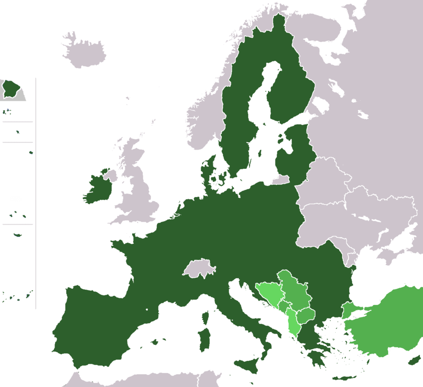
Map of the European Union with (1) member states after the 2013 enlargement, (2) candidate countries Turkey, FYR Macedonia, Montenegro, Serbia and Iceland, (3) at left (some of) the territories of France, Portugal and Spain, and (4) the potential member states (is an official EU-status, see EU-website) of the European Union (Albania, Bosnia-Herzegovina).
- France – Overseas departments (Départements d'outre-mer)
- on the North-East coast of South America:
- French Guiana
- islands in the Caribbean:
- Guadeloupe (with Saint Martin and Saint-Barthélemy)
- Martinique
- islands in the Atlantic Ocean in North America:
- Saint Pierre and Miquelon
- islands in the Indian Ocean:
- Réunion
- Mayotte - not shown
- on the North-East coast of South America:
- Portugal
- islands in the Atlantic Ocean:
- Azores
- Madeira
- islands in the Atlantic Ocean:
- Spain
- islands in the Atlantic Ocean:
- Canary Islands
- cities on the Coast of North Africa:
- Ceuta
- Melilla
- islands in the Atlantic Ocean:
Author: wiki-vr 19:38, 26 Mar 2005 (UTC)
Based on: http://en.wikipedia.org/wiki/Image:Europe_blank_map.png
| Ten utwór został udostępniony jako własność publiczna przez jego autora, Wiki-vr. Dotyczy to całego świata. W niektórych krajach może nie być to prawnie możliwe, jeśli tak, to: |
Historia pliku
Kliknij na datę/czas, aby zobaczyć, jak plik wyglądał w tym czasie.
| Data i czas | Miniatura | Wymiary | Użytkownik | Opis | |
|---|---|---|---|---|---|
| aktualny | 21:05, 10 lut 2020 | | 1360 × 1245 (25 KB) | Hektor Absurdus | Iceland is no longer a candidate state |
| 20:44, 7 lut 2020 |  | 1360 × 1245 (25 KB) | Hektor Absurdus | - UK | |
| 01:23, 25 sty 2014 |  | 1360 × 1245 (24 KB) | Hektor Absurdus | + Croatia, updated candidates | |
| 10:54, 1 lut 2008 |  | 1360 × 1245 (28 KB) | Xiong Chiamiov | optimized using optipng | |
| 11:28, 25 sty 2007 |  | 1360 × 1245 (81 KB) | Hoshie | added Ceuta, Melilla. Sint Maarten, the SBAs, and Crown Dependencies aren't in EU. | |
| 05:21, 1 sty 2007 |  | 1360 × 1245 (81 KB) | Cassini83 | ||
| 14:05, 29 gru 2006 |  | 1360 × 1245 (81 KB) | Palazov~commonswiki | add Montenegro | |
| 11:35, 29 gru 2006 |  | 1360 × 1245 (81 KB) | Palazov~commonswiki | Author: wiki-vr 19:38, 26 Mar 2005 (UTC) Based on: http://en.wikipedia.org/wiki/Image:Europe_blank_map.png {{PD-user|Wiki-vr}} Category:Maps of the European Union | |
| 22:25, 25 maj 2006 |  | 1360 × 1245 (59 KB) | Wiki-vr | all the enlargements to come, hues of green | |
| 01:11, 24 mar 2006 |  | 1360 × 1245 (71 KB) | Valentinian | All other borders inside the union were already removed, so removed the Danish-German one as well. Minor fixes in North Jutland (Denmark). |
Lokalne wykorzystanie pliku
Następujące strony korzystają z tego pliku:
Globalne wykorzystanie pliku
Ten plik jest wykorzystywany także w innych projektach wiki:
- Wykorzystanie na en.wikipedia.org