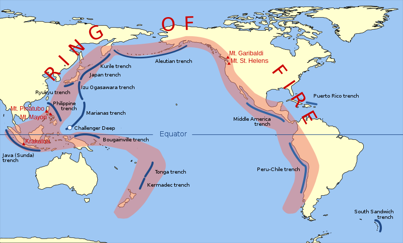
Plik:Pacific Ring of Fire.svg
Wygląd

Wielkość pliku podglądu PNG dla pliku SVG: 800 × 483 pikseli Inne rozdzielczości: 320 × 193 pikseli | 640 × 387 pikseli | 1024 × 619 pikseli | 1280 × 773 pikseli | 2560 × 1546 pikseli | 942 × 569 pikseli.
Rozmiar pierwotny (Plik SVG, nominalnie 942 × 569 pikseli, rozmiar pliku: 294 KB)
Historia pliku
Kliknij na datę/czas, aby zobaczyć, jak plik wyglądał w tym czasie.
| Data i czas | Miniatura | Wymiary | Użytkownik | Opis | |
|---|---|---|---|---|---|
| aktualny | 13:30, 20 mar 2015 |  | 942 × 569 (294 KB) | Szczureq | Ryuku → Ryukyu |
| 15:19, 15 mar 2011 |  | 942 × 569 (294 KB) | AnonMoos | trimming transparent margins | |
| 21:25, 3 mar 2009 |  | 796 × 472 (314 KB) | Kmusser | Fix volanco symbols | |
| 21:04, 3 mar 2009 |  | 796 × 472 (317 KB) | Kmusser | repositioned volcanoes | |
| 01:24, 14 lut 2009 |  | 781 × 472 (145 KB) | Inductiveload | added volcanos | |
| 19:18, 11 lut 2009 |  | 781 × 472 (138 KB) | Inductiveload | added labels, aluetian isles and south sandwich islands, as these are associated with the nearby trenches. also put everything into layers. | |
| 01:58, 11 lut 2009 |  | 781 × 472 (111 KB) | Gringer | Resized image 3x so that nominal size is reasonable in default Wikipedia image display. | |
| 01:52, 11 lut 2009 |  | 260 × 157 (112 KB) | Gringer | {{Information |Description={{en|1=SVG version of File:Pacific_Ring_of_Fire.png, recreated by me using WDB vector data using code mentioned in File:Worldmap_wdb_combined.svg.}} |Source=vector data from [http://www.evl.uic.edu/pape/data/WDB/] |Aut |
Lokalne wykorzystanie pliku
Poniższa strona korzysta z tego pliku:
Globalne wykorzystanie pliku
Ten plik jest wykorzystywany także w innych projektach wiki:
- Wykorzystanie na af.wikipedia.org
- Wykorzystanie na ar.wikipedia.org
- Wykorzystanie na ast.wikipedia.org
- Wykorzystanie na ban.wikipedia.org
- Wykorzystanie na bcl.wikipedia.org
- Wykorzystanie na bg.wikipedia.org
- Wykorzystanie na bn.wikipedia.org
- Wykorzystanie na bs.wikipedia.org
- Wykorzystanie na da.wikipedia.org
- Wykorzystanie na el.wikipedia.org
- Wykorzystanie na en.wikipedia.org
- Wykorzystanie na en.wikibooks.org
- Wykorzystanie na en.wikivoyage.org
- Wykorzystanie na en.wiktionary.org
- Wykorzystanie na es.wikipedia.org
- Wykorzystanie na fa.wikipedia.org
- Wykorzystanie na fi.wikipedia.org
- Wykorzystanie na he.wikipedia.org
- Wykorzystanie na hi.wikipedia.org
- Wykorzystanie na hu.wikipedia.org
- Wykorzystanie na ilo.wikipedia.org
- Wykorzystanie na incubator.wikimedia.org
- Wykorzystanie na is.wikipedia.org
- Wykorzystanie na is.wikibooks.org
- Wykorzystanie na it.wikibooks.org
- Wykorzystanie na ja.wikipedia.org
- Wykorzystanie na ja.wikibooks.org
- Wykorzystanie na jv.wikipedia.org
- Wykorzystanie na ka.wikipedia.org
- Wykorzystanie na kk.wikipedia.org
- Wykorzystanie na la.wikipedia.org
Pokaż listę globalnego wykorzystania tego pliku.


