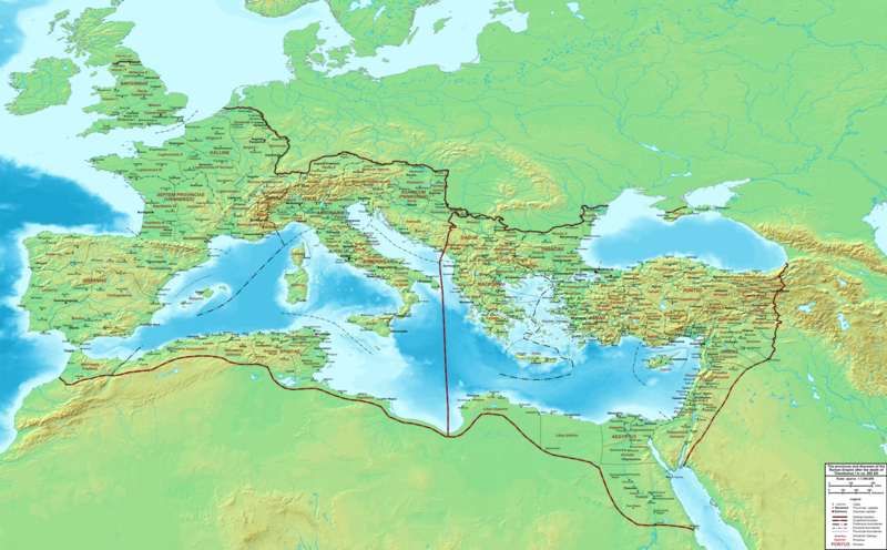
Plik:The Roman Empire ca 400 AD.png
Wygląd

Rozmiar podglądu – 800 × 496 pikseli. Inne rozdzielczości: 320 × 198 pikseli | 640 × 397 pikseli | 1024 × 635 pikseli | 1280 × 793 pikseli | 2560 × 1587 pikseli | 4339 × 2689 pikseli.
Rozmiar pierwotny (4339 × 2689 pikseli, rozmiar pliku: 12,8 MB, typ MIME: image/png)
Historia pliku
Kliknij na datę/czas, aby zobaczyć, jak plik wyglądał w tym czasie.
| Data i czas | Miniatura | Wymiary | Użytkownik | Opis | |
|---|---|---|---|---|---|
| aktualny | 00:27, 20 lut 2015 |  | 4339 × 2689 (12,8 MB) | Cplakidas | added potential location of Valentia beyond Hadrian's Wall, removed provincial boundaries in Britannia as too tentative |
| 15:03, 21 lip 2011 |  | 4339 × 2689 (10,9 MB) | Cplakidas | fixed Persian border, differentiated between Eastern and Western empire, different borders for praet. prefectures | |
| 04:37, 21 mar 2009 |  | 4475 × 2600 (9,99 MB) | Cplakidas | minor corrections | |
| 14:30, 29 maj 2008 |  | 3800 × 2370 (8,1 MB) | Cplakidas | ||
| 14:17, 29 maj 2008 |  | 4560 × 2850 (11,22 MB) | Cplakidas | clearer version & addition of the Armenian satrapies | |
| 04:02, 30 gru 2007 |  | 3380 × 2120 (5,96 MB) | Cplakidas | added names of dioceses, legend box, various minor adjustments | |
| 16:27, 13 gru 2007 |  | 3550 × 2200 (6,65 MB) | Cplakidas | new improved version made with Inkscape, slight corrections in borders, added several cities in Africa & Spain | |
| 21:27, 12 lis 2007 |  | 3550 × 2200 (4,75 MB) | Cplakidas | minor corrections in southern Gaul | |
| 14:58, 5 lis 2007 |  | 3550 × 2200 (4,75 MB) | Cplakidas | New version, with some corrections & additions | |
| 18:55, 31 paź 2007 |  | 3436 × 2142 (4,5 MB) | Cplakidas | {{Information |Description=Map of the Roman Empire ca. 400 AD, showing the administrative division into dioceses and provinces, as well as the major cities. The demarcation between Eastern and Western Empires is noted in red. |Source=Base map found at |
Lokalne wykorzystanie pliku
Żadna strona nie korzysta z tego pliku.
Globalne wykorzystanie pliku
Ten plik jest wykorzystywany także w innych projektach wiki:
- Wykorzystanie na af.wikipedia.org
- Wykorzystanie na ar.wikipedia.org
- Wykorzystanie na ary.wikipedia.org
- Wykorzystanie na ast.wikipedia.org
- Wykorzystanie na bg.wikipedia.org
- Wykorzystanie na bn.wikipedia.org
- Wykorzystanie na ca.wikipedia.org
- Wykorzystanie na ceb.wikipedia.org
- Wykorzystanie na cs.wikipedia.org
- Wykorzystanie na de.wikipedia.org
- Wykorzystanie na el.wikipedia.org
- Wykorzystanie na en.wikipedia.org
- Wykorzystanie na eo.wikipedia.org
- Wykorzystanie na es.wikipedia.org
- Wykorzystanie na et.wikipedia.org
- Wykorzystanie na fr.wikipedia.org
- Wykorzystanie na he.wikipedia.org
- Wykorzystanie na hi.wikipedia.org
- Wykorzystanie na hr.wikipedia.org
- Wykorzystanie na hu.wikipedia.org
- Wykorzystanie na id.wikipedia.org
- Wykorzystanie na it.wikipedia.org
- Wykorzystanie na ko.wikipedia.org
- Wykorzystanie na la.wikipedia.org
Pokaż listę globalnego wykorzystania tego pliku.


