
Plik:Tlingit-map.png
Rozmiar pierwotny (637 × 1057 pikseli, rozmiar pliku: 169 KB, typ MIME: image/png)
| Plik Tlingit-map.png znajduje się w Wikimedia Commons – repozytorium wolnych zasobów. Dane z jego strony opisu znajdują się poniżej. |
info
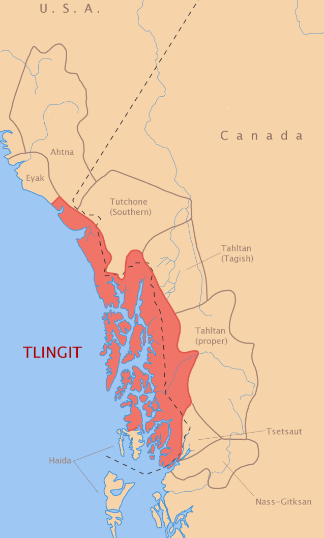
(draft #1)
- created by en:User:ish ishwar in 2005
- released under CC-by-2.0
Map redrawn and modified from the map of North American Indian languages appearing in Goddard (1996) and as Goddard (1999).
- language areas are not as well-defined as this map would suggest: borders are often fuzzy and arbitrary and the entire language area may not be fully occupied by language speakers.
- many details, especially of rivers, lakes, & islands, have been omitted.
Goddard (1996, 1999) is a map of the entire North American continent and thus contains compromises concerning the full extent indigenous people's homelands. This is certainly the case with the Tlingit peoples (cf. also Chiricahua Apache). The majority of Tlingit-speaking peoples were coastal — this is shown in Goddard's maps. However, there were also Tlingit peoples further inland (called by such names as Inland Tlingit, Teslin, Atlin, Carcross). This inland area is not shown on Goddard's maps as the area overlaps with neighboring peoples (?). Since this map is currently based solely on Goddard (1996, 1999), it also does not display this area. This may be adjusted some time in future.
At this time the reader is recommended to compare this map with others listed in the bibliography below, esp.
- (Fig. 2) "Late 19th-early 20th Century territory with modern reserves" in McClellan (1981:471),
- overview map of the Subarctic culture area in Helm (1981:viii-xi).
- (Fig. 1) "Territories and former settlements of the Tlingit" in De Laguna (1990:204),
- overview map of the Northwest Coast culture area in Suttles (1990:viii-ix), and
- also concerning info about Inland Tlingit territory, see McClellan (1981:469-471).
note about neighbors:
The Tlingit peoples are surrounded by mostly Athabaskan speakers.
- Ahtna, Southern Tutchone, Tagish, Tahltan (proper), and Tsetsaut are Athabaskan (of the Na-Dene family).
- Eyak, a northern neighbor, is a Na-Dene language (although not Athabaskan).
- Nass-Gitksan is a Tsimshian language (which is not related to the Na-Dene family).
- Haida, who shares an island with Tlingit speakers, is a language isolate, unrelated to Na-Dene or Tsimshian families.
Tlingit itself is Na-Dene, related to Eyak and the Athabaskan languages.
to do
- show Inland Tlingit (see de Laguna 1991 and ANLC maps)
- show mixed Tlingit-Eyak area from Yakutat area to Cape Spencer (cf. ANLC map)
- label rivers and major lakes
- label major villages and towns
- Yakutat, Hoonah, Haines, Juneau, Sitka, Angoon, Wrangell, Kake, Klawock, Ketchikan
- possibly add borders of major Tlingit kwáan divisions?
- see Hope's Traditional Tlingit Country map
links
bibliography
- Campbell, Lyle. (1997). American Indian languages: The historical linguistics of Native America. New York: Oxford University Press. ISBN 0-19-509427-1.
- De Laguna, Frederica. (1990). Tlingit. In W. Suttles (Ed.), Northwest Coast (pp. 203-228). Handbook of North American Indians (Vol. 7). Washington, D.C.: Smithsonian Institution.
- Goddard, Ives (Ed.). (1996). Languages. Handbook of North American Indians (W. C. Sturtevant, General Ed.) (Vol. 17). Washington, D. C.: Smithsonian Institution. ISBN 0-1604-8774-9.
- Goddard, Ives. (1999). Native languages and language families of North America (rev. and enlarged ed. with additions and corrections). [Map]. Lincoln, NE: University of Nebraska Press (Smithsonian Institute). (Updated version of the map in Goddard 1996). ISBN 0-8032-9271-6.
- Helm, June (Ed.). (1981). Subartic. Handbook of Native American Indians (Vol. 6) (W. C. Sturtevant, General Ed.). Washington, D.C.: Smithsonian Institution.
- Krauss, Michael. (1982). Native peoples and languages of Alaska (rev. ed.). [Map]. Fairbanks, AK: Alaska Native Language Center. ISBN 0-933769-00-8.
- McClellan, Catharine. (1981). Inland Tlingit. In J. Helm (Ed.), Subarctic (pp. 469-480). Handbook of Native American Indians (Vol. 6). Washington, D.C.: Smithsonian Institution.
- Mithun, Marianne. (1999). The languages of Native North America. Cambridge: Cambridge University Press. ISBN 0-521-23228-7 (hbk); ISBN 0-521-29875-X.
- Sturtevant, William C. (Ed.). (1978-present). Handbook of North American Indians (Vol. 1-20). Washington, D. C.: Smithsonian Institution. (Vols. 1-3, 16, 18-20 not yet published).
- Suttles, Wayne (Ed.). (1990). Northwest Coast. Handbook of North American Indians (Vol. 7) (W. C. Sturtevant, General Ed.). Washington, D.C.: Smithsonian Institution.
- Wolno:
- dzielić się – kopiować, rozpowszechniać, odtwarzać i wykonywać utwór
- modyfikować – tworzyć utwory zależne
- Na następujących warunkach:
- uznanie autorstwa – musisz określić autorstwo utworu, podać link do licencji, a także wskazać czy utwór został zmieniony. Możesz to zrobić w każdy rozsądny sposób, o ile nie będzie to sugerować, że licencjodawca popiera Ciebie lub Twoje użycie utworu.
Historia pliku
Kliknij na datę/czas, aby zobaczyć, jak plik wyglądał w tym czasie.
| Data i czas | Miniatura | Wymiary | Użytkownik | Opis | |
|---|---|---|---|---|---|
| aktualny | 07:01, 20 lip 2010 | | 637 × 1057 (169 KB) | Nvvchar | Cropped to reduce size |
| 06:41, 19 sty 2006 |  | 768 × 1590 (238 KB) | Ish ishwar | rv | |
| 00:24, 27 lis 2005 |  | 180 × 373 (38 KB) | Walden69 | Mapa vikipedia english | |
| 04:49, 2 cze 2005 |  | 768 × 1590 (238 KB) | Ish ishwar | map of Tlingit and surrounding peoples |
Lokalne wykorzystanie pliku
Następujące strony korzystają z tego pliku:
Globalne wykorzystanie pliku
Ten plik jest wykorzystywany także w innych projektach wiki:
- Wykorzystanie na av.wikipedia.org
- Wykorzystanie na be.wikipedia.org
- Wykorzystanie na ca.wikipedia.org
- Wykorzystanie na da.wikipedia.org
- Wykorzystanie na de.wikipedia.org
- Wykorzystanie na en.wikipedia.org
- Wykorzystanie na eo.wikipedia.org
- Wykorzystanie na es.wikipedia.org
- Wykorzystanie na et.wikipedia.org
- Wykorzystanie na eu.wikipedia.org
- Wykorzystanie na fa.wikipedia.org
- Wykorzystanie na fr.wikipedia.org
- Wykorzystanie na hr.wikipedia.org
- Wykorzystanie na hu.wikipedia.org
- Wykorzystanie na id.wikipedia.org
- Wykorzystanie na incubator.wikimedia.org
- Wykorzystanie na it.wikipedia.org
- Wykorzystanie na ja.wikipedia.org
- Wykorzystanie na ko.wikipedia.org
- Wykorzystanie na lv.wikipedia.org
- Wykorzystanie na mrj.wikipedia.org
- Wykorzystanie na nl.wikipedia.org
- Wykorzystanie na no.wikipedia.org
Pokaż listę globalnego wykorzystania tego pliku.