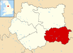
City of Wakefield
Na mapach: 53°40′58,8″N 1°29′56,4″W/53,683000 -1,499000
| dystrykt metropolitalny | |||

| |||
| |||
| Państwo | |||
|---|---|---|---|
| Kraj | |||
| Region | |||
| Hrabstwo | |||
| Siedziba | |||
| Powierzchnia |
339 km² | ||
| Populacja (2016) • liczba ludności |
| ||
| • gęstość |
994 os./km² | ||
Położenie na mapie West Yorkshire
| |||
| Strona internetowa | |||
City of Wakefield – dystrykt metropolitalny[2] w hrabstwie ceremonialnym West Yorkshire w Anglii.
Miasta[edytuj | edytuj kod]
- Castleford
- Featherstone
- Hemsworth
- Knottingley
- Normanton
- Ossett
- Pontefract
- South Elmsall
- South Kirkby and Moorthorpe
- Wakefield
Inne miejscowości[edytuj | edytuj kod]
Ackworth, Ackton, Agbrigg, Altofts, Alverthorpe, Badsworth, Brandy Carr, Crigglestone, Crofton, Darrington, Durkar, East Hardwick, Ferrybridge, Fitzwilliam, Foulby, Gawthorpe, Haigh, Havercroft, Horbury, Kettlethorpe, Kinsley, Kirkhamgate, Kirkthorpe, Middlestown, Monkhill, Netherton, Newland with Woodhouse Moor, Newmillerdam, North Elmsall, Nostell, Notton, Outwood, Overton, Ryhill, Sharlston, South Hiendley, Stanley, Streethouse, Thorpe Audlin, Upton, Walton, West Bretton, West Hardwick, Wintersett, Woolley Colliery, Woolley, Wrenthorpe.
Przypisy[edytuj | edytuj kod]
- ↑ Population Estimates for UK, England and Wales, Scotland and Northern Ireland - Office for National Statistics [online], www.ons.gov.uk [dostęp 2017-10-22] (ang.).
- ↑ Ordnance Survey linked data

