Plik:Aral sea.gif

Treść strony nie jest dostępna w innych językach.
Ten plik jest umieszczony w Wikimedia Commons
Z Wikipedii, wolnej encyklopedii

Rozmiar pierwotny(720 × 720 pikseli, rozmiar pliku: 3,16 MB, typ MIME: image/gif, zapętlony, 12 klatek, 12 s)

Opis

Opis
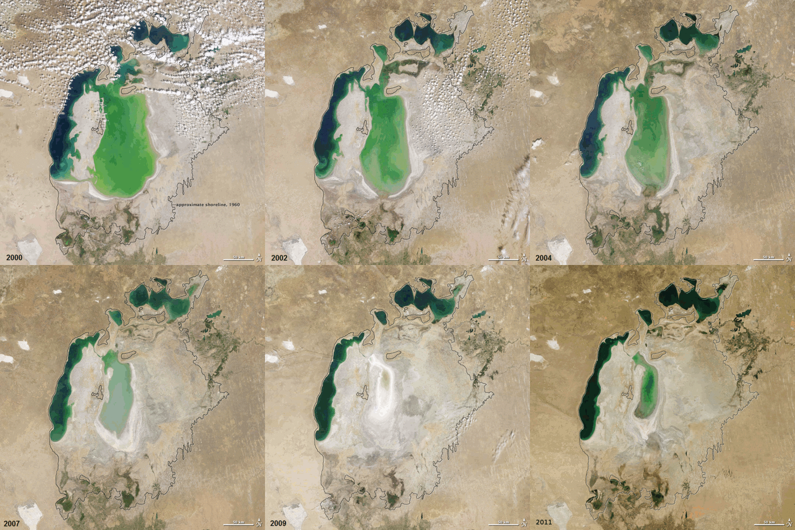
English: In the 1960s, the Soviet Union undertook a major water diversion project on the arid plains of Kazakhstan, Uzbekistan, and Turkmenistan. The region’s two major rivers, fed from snowmelt and precipitation in far-away mountains, were used to transform the desert into fields for cotton and other crops. Before the project, the two rivers left the mountains, cut northwest through the Kyzylkum Desert—the Syrdar’ya to the north and the Amudar’ya in parallel to the south—and finally pooled together in the lowest part of the desert basin. The lake they made, the Aral Sea, was once the fourth largest lake in the world.

Although irrigation made the desert bloom, it devastated the Aral Sea. This series of images from the Moderate Resolution Imaging Spectroradiometer (MODIS) on NASA’s Terra satellite documents the changes in the the Aral Sea throughout the past decade. At the start of the series in 2000, the lake was already a fraction of its 1960 extent (black line). The Northern Aral Sea (sometimes called the Small Aral Sea) had separated from the Southern (Large) Aral Sea. The Southern Aral Sea had split into an eastern and a western lobe that remained tenuously connected at both ends.

By 2001, the southern connection had been severed, and the shallower eastern part retreated rapidly over the next several years. Especially large retreats in the eastern lobe of the Southern Sea appear to have occurred between 2005 and 2006, and again between 2007 and 2008. The final image in the series is from the summer of 2009. Blowing dust (salt-laden sediments) covers a large part of the sea.

As the lake dried up, fisheries and the communities that depended on them collapsed. The increasingly salty water became polluted with fertilizer and pesticides. The blowing dust from the exposed lakebed, contaminated with agricultural chemicals, became a public health hazard. The salty dust blew off the lakebed and settled onto fields, degrading the soil. Croplands had to be flushed with larger and larger volumes of river water. The loss of the moderating influence of such a large body of water made winters colder and summers hotter and drier.

In a last-ditch effort to save some of the lake, Kazakhstan built a dam between the northern and southern parts of the Aral Sea. Completed in 2005, the dam was basically a death sentence for the southern Aral Sea, which was judged to be beyond saving. All of the water flowing into the desert basin from the Syrdar’ya now stays in the Northern Aral Sea. Between 2005 and 2006, the water levels in that part of the lake rebounded significantly and very small increases are visible throughout the rest of the time period. The differences in water color are due to changes in sediment.
 
Ta GIF grafika rastrowa została stworzona za pomocą GIMP.
Data between 2000-now for the photos
Źródło Evaporation of the Aral Sea
Autor NASA Earth Observatory for the photos. ComputerHotline for the animation.
Thomas Bresson  
 
Thomas Bresson
Inne nazwiska i pseudonimy
Opis francuski fotografik
Data urodzenia 31 grudnia 1982
Miejsce urodzenia Belfort
Okres działalności od 2008
date QS:P,+2008-00-00T00:00:00Z/7,P580,+2008-00-00T00:00:00Z/9
This photo / video was taken by Thomas Bresson.

Please credit this with : Photo : Thomas Bresson or Video : Thomas Bresson in the immediate vicinity of the image.

If you use one of my photos, please email me (account needed) or leave me a short message on my discussion page.
It would be greatly appreciated.
Do not copy this image illegally by ignoring the terms of the license below, as it is not in the public domain.

If you would like special permission to use, license, or purchase the image please contact me to negotiate terms.


العربية | বাংলা | English | français | македонски | Nederlands | Türkçe | +/−

Licencja

Public domain Ten plik jest w domenie publicznej ponieważ został stworzony przez NASA. Polityka praw autorskich NASA stwierdza, że „materiały NASA nie są chronione prawami autorskimi, chyba że zapisano inaczej”. (NASA copyright policy lub JPL Image Use Policy).
Uwaga:
  • Użycie dowolnego ze znaków graficznych NASA jest ograniczone przez prawo w USA 14 CFR 1221.
  • Strony NASA udostępniają dużą liczbę zdjęć z radzieckiej, rosyjskiej, a także innych agencji kosmicznych. Nie muszą być one w domenie publicznej.
  • Materiały z Kosmicznego Teleskopu Hubble'a mogą być objęte prawami autorskimi jeśli nie pochodzą bezpośrednio ze Space Telescope Science Institute[1].
  • Wszystkie materiały powstałe w ramach działalności sondy SOHO są objęte prawami autorskimi i wymagają zgody na ich komercyjne i nieedukacyjne użycie[2].
  • Zdjęcia pojawiające się na stronie Astronomy Picture of the Day (Astronomiczne zdjęcie dnia) mogą być objęte prawem autorskim[3].

Podpisy

Dodaj jednolinijkowe objaśnienie tego, co ten plik pokazuje

Obiekty przedstawione na tym zdjęciu

przedstawia

image/gif

2912d7b11570f27abb8244fa3e774509570b3d9d

3 316 632 bajt

12 sekunda

720 piksel

720 piksel

Historia pliku

Kliknij na datę/czas, aby zobaczyć, jak plik wyglądał w tym czasie.

Data i czasMiniaturaWymiaryUżytkownikOpis
aktualny09:38, 19 gru 2011Miniatura wersji z 09:38, 19 gru 2011720 × 720 (3,16 MB)ComputerHotline== Summary == {{Information |Description={{en|In the 1960s, the Soviet Union undertook a major water diversion project on the arid plains of Kazakhstan, Uzbekistan, and Turkmenistan. The region’s two major rivers, fed from snowmelt and precipitation in
14:19, 25 gru 2010Miniatura wersji z 14:19, 25 gru 2010720 × 720 (2,92 MB)ComputerHotline== Summary == {{Information |Description={{en|In the 1960s, the Soviet Union undertook a major water diversion project on the arid plains of Kazakhstan, Uzbekistan, and Turkmenistan. The region’s two major rivers, fed from snowmelt and precipitation in

Następujące strony korzystają z tego pliku:

Globalne wykorzystanie pliku

Ten plik jest wykorzystywany także w innych projektach wiki: