Plik:Jan 2011 Cloud Streets North Atlantic.jpg

Treść strony nie jest dostępna w innych językach.
Ten plik jest umieszczony w Wikimedia Commons
Z Wikipedii, wolnej encyklopedii

Rozmiar pierwotny(6400 × 7600 pikseli, rozmiar pliku: 6,76 MB, typ MIME: image/jpeg)

Opis

Opis
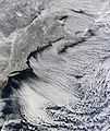
English: Natural-colour view of New England, the Canadian Maritimes, and coastal waters at 10:25 a.m. U.S. Eastern Standard Time. Lines of clouds stretch from north-west to south-east over the North Atlantic, while the relatively cloudless skies over land afford a peek at the snow that blanketed the North-east just a few days earlier.

NASA image acquired January 24, 2011

Between two major and debilitating storms, a cold Arctic air mass brought bitter chill, moderate snow, and strong winds to the eastern United States and Canada. On January 24, 2011, the snow clouds finally parted, allowing the Moderate Resolution Imaging Spectroradiometer (MODIS) aboard the Terra satellite to capture this spectacular true-color image of the winter-bound region.

A frosty white glaze covers the tan land of the northeastern United States and the provinces of Quebec, New Brunswick, and Nova Scotia, Canada. Off the entire eastern coast, a massive bank of clouds stretches far across the Atlantic Ocean in delicately arcing, parallel rows. These formations, known as “cloud streets”, have been sculpted by the prevailing westerly winds. When strong wind emerging from a cold surface blows over the warmer, moister atmosphere over the open ocean, cylinders of spinning air may develop in very regular, linear patterns. Clouds form along the upward cycle in the cylinders, where the air is rising, while skies remain relatively clear along the downward cycle, where air is falling. The result is a remarkably regular striped pattern of parallel lines in the clouds.

On January 24, when this image was captured, intense snow squalls with winds up to 100 km/hr were reported across Newfoundland. Even inland, in Quebec City, winds of 41 km/hr, along with bitter cold lows of -28°C were recorded. Newfoundland is in the upper right corner of this image, mostly hidden under a thick layer of snow-bearing clouds. These clouds, much like those over the ocean, align with the westerly wind. Wispy clouds on the far left of the image can also be seen aligned in a similar direction.

This image was captured in relatively calm weather between two blizzards which pummeled the northeastern United States. The first storm, which formed in the Gulf of Mexico and swept northeastward, covered Texas with white on January 8, then ended on January 13 after dumping over two feet of snow in parts of New England. The second, January 25 through 27, was a fast-moving, intense storm that brought 10-15 inches of fresh snow to most of New England and caused power outages to 650,000 in the Washington, DC metro area.

Credit: NASA/GSFC/Jeff Schmaltz/MODIS Land Rapid Response Team

NASA Goddard Space Flight Center enables NASA’s mission through four scientific endeavors: Earth Science, Heliophysics, Solar System Exploration, and Astrophysics. Goddard plays a leading role in NASA’s accomplishments by contributing compelling scientific knowledge to advance the Agency’s mission.

Follow us on Twitter

Join us on Facebook
Data
Źródło NASA Earth Observatory
Cloud streets off eastern United States and Canada
Autor Jeff Schmaltz, NASA Goddard Space Flight Center from Greenbelt, MD, USA

Image captured by the Moderate Resolution Imaging Spectroradiometer (MODIS) on NASA’s Terra satellite.

Licencja

Public domain Ten plik jest w domenie publicznej ponieważ został stworzony przez NASA. Polityka praw autorskich NASA stwierdza, że „materiały NASA nie są chronione prawami autorskimi, chyba że zapisano inaczej”. (NASA copyright policy lub JPL Image Use Policy).
Uwaga:
  • Użycie dowolnego ze znaków graficznych NASA jest ograniczone przez prawo w USA 14 CFR 1221.
  • Strony NASA udostępniają dużą liczbę zdjęć z radzieckiej, rosyjskiej, a także innych agencji kosmicznych. Nie muszą być one w domenie publicznej.
  • Materiały z Kosmicznego Teleskopu Hubble'a mogą być objęte prawami autorskimi jeśli nie pochodzą bezpośrednio ze Space Telescope Science Institute[1].
  • Wszystkie materiały powstałe w ramach działalności sondy SOHO są objęte prawami autorskimi i wymagają zgody na ich komercyjne i nieedukacyjne użycie[2].
  • Zdjęcia pojawiające się na stronie Astronomy Picture of the Day (Astronomiczne zdjęcie dnia) mogą być objęte prawem autorskim[3].
w:pl:Licencje Creative Commons
uznanie autorstwa
Ten plik udostępniony jest na licencji Creative Commons Uznanie autorstwa 2.0.
Wolno:
  • dzielić się – kopiować, rozpowszechniać, odtwarzać i wykonywać utwór
  • modyfikować – tworzyć utwory zależne
Na następujących warunkach:
  • uznanie autorstwa – musisz określić autorstwo utworu, podać link do licencji, a także wskazać czy utwór został zmieniony. Możesz to zrobić w każdy rozsądny sposób, o ile nie będzie to sugerować, że licencjodawca popiera Ciebie lub Twoje użycie utworu.
Ten plik, opublikowany pierwotnie w serwisie Flickr przez NASA Goddard Photo and Video pod adresem https://flickr.com/photos/24662369@N07/5395476209, został sprawdzony 27 września 2017 przez FlickreviewR, który potwierdził, że jest on tam dostępny na licencji cc-by-2.0.

27 września 2017

Podpisy

Dodaj jednolinijkowe objaśnienie tego, co ten plik pokazuje

Obiekty przedstawione na tym zdjęciu

przedstawia

image/jpeg

Historia pliku

Kliknij na datę/czas, aby zobaczyć, jak plik wyglądał w tym czasie.

Data i czasMiniaturaWymiaryUżytkownikOpis
aktualny14:58, 26 sty 2013Miniatura wersji z 14:58, 26 sty 20136400 × 7600 (6,76 MB)Slick-o-botBot: convert to a non-interlaced jpeg (see bug #17645)
12:24, 15 lut 2011Miniatura wersji z 12:24, 15 lut 20116400 × 7600 (6,48 MB)Originalwana{{Information |Description ={{en|1=Natural-colour view of New England, the Canadian Maritimes, and coastal waters at 10:25 a.m. U.S. Eastern Standard Time. Lines of clouds stretch from north-west to south-east over the North Atlantic, while the relativ

Poniższa strona korzysta z tego pliku:

Globalne wykorzystanie pliku

Ten plik jest wykorzystywany także w innych projektach wiki:

Metadane