
Plik:Kingdom of Germany 1004.svg

Wielkość pliku podglądu PNG dla pliku SVG: 485 × 340 pikseli Inne rozdzielczości: 320 × 224 pikseli | 640 × 449 pikseli | 1024 × 718 pikseli | 1280 × 897 pikseli | 2560 × 1795 pikseli.
Rozmiar pierwotny (Plik SVG, nominalnie 485 × 340 pikseli, rozmiar pliku: 1,23 MB)
| Plik Kingdom of Germany 1004.svg znajduje się w Wikimedia Commons – repozytorium wolnych zasobów. Dane z jego strony opisu znajdują się poniżej. |
Opis
Ta ^specifik^ z W3C grafika wektorowa została stworzona za pomocą Inkscape .


.svg)
.svg)
.svg)
.svg)
.svg)


.svg)
.svg)
.svg)


.png)
.png)


.svg)


.svg)

.svg)


.svg)
.svg)
.svg)
.svg)


.svg)
.png)


.svg)


.svg)
.svg)


.svg)


.svg)


.svg)
.svg)
.svg)
.svg)
.svg)
.svg)
.svg)
.svg)
_cropped.svg)
.svg)
.svg)
.svg)
.svg)
.svg)
.svg)
.svg)
.svg)
.svg)
.svg)
.svg)
.svg)
.svg)
.svg)
.svg)
.svg)
.svg)
.svg)
.svg)
.svg)
.svg)
.svg)
.svg)
.svg)
.svg)
.svg)
.svg)
.svg)
.svg)
.svg)
.svg)
.svg)
.svg)
.svg)
.svg)
.svg)
.svg)
.svg)
.svg)
.svg)
.svg)
.svg)
.svg)
.svg)
.svg)
Licencja
Ten plik udostępniony jest na licencji Creative Commons Uznanie autorstwa – Na tych samych warunkach 4.0 Międzynarodowe.
- Wolno:
- dzielić się – kopiować, rozpowszechniać, odtwarzać i wykonywać utwór
- modyfikować – tworzyć utwory zależne
- Na następujących warunkach:
- uznanie autorstwa – musisz określić autorstwo utworu, podać link do licencji, a także wskazać czy utwór został zmieniony. Możesz to zrobić w każdy rozsądny sposób, o ile nie będzie to sugerować, że licencjodawca popiera Ciebie lub Twoje użycie utworu.
- na tych samych warunkach – Jeśli zmienia się lub przekształca niniejszy utwór, lub tworzy inny na jego podstawie, można rozpowszechniać powstały w ten sposób nowy utwór tylko na podstawie tej samej lub podobnej licencji.
Historia pliku
Kliknij na datę/czas, aby zobaczyć, jak plik wyglądał w tym czasie.
| Data i czas | Miniatura | Wymiary | Użytkownik | Opis | |
|---|---|---|---|---|---|
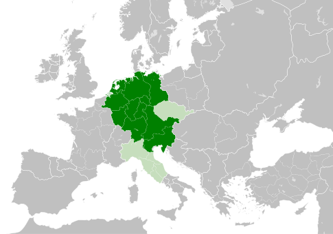
| aktualny | 13:49, 4 maj 2021 | | 485 × 340 (1,23 MB) | E-960 | Tribute was paid under Mieszko I, by the year 1000 Bolesław I the Brave stopped paying it |
| 15:14, 23 maj 2016 |  | 485 × 340 (1,23 MB) | Der Golem | Duchy of Bohemia was part of the Holy Roman Empire, but not within the Kingdom of Germany | |
| 22:19, 22 maj 2016 |  | 485 × 340 (1,23 MB) | Alphathon | == {{int:filedesc}} == {{Inkscape}} {{Information |Description={{en|A map of the Kingdom of Germany within the Holy Roman Empire and within Europe circa 1004 CE, after the incorporation of the [[:en:Duchy of Bohemia|Duchy of... |
Lokalne wykorzystanie pliku
Następujące strony korzystają z tego pliku:
Globalne wykorzystanie pliku
Ten plik jest wykorzystywany także w innych projektach wiki:
- Wykorzystanie na az.wikipedia.org
- Wykorzystanie na ba.wikipedia.org
- Wykorzystanie na be.wikipedia.org
- Wykorzystanie na ca.wikipedia.org
- Wykorzystanie na cs.wikipedia.org
- Wykorzystanie na en.wikipedia.org
- Wykorzystanie na eo.wikipedia.org
- Wykorzystanie na es.wikipedia.org
- Wykorzystanie na et.wikipedia.org
- Wykorzystanie na eu.wikipedia.org
- Wykorzystanie na fr.wikipedia.org
- Wykorzystanie na id.wikipedia.org
- Wykorzystanie na ja.wikipedia.org
- Wykorzystanie na ko.wikipedia.org
- Wykorzystanie na la.wikipedia.org
- Wykorzystanie na lv.wikipedia.org
- Wykorzystanie na ru.wikipedia.org
- Wykorzystanie na uk.wikipedia.org
- Wykorzystanie na www.wikidata.org
.svg)