
Plik:Map Kingdom of Westphalia.jpg
Grafika w wyższej rozdzielczości nie jest dostępna.
Map_Kingdom_of_Westphalia.jpg (348 × 409 pikseli, rozmiar pliku: 68 KB, typ MIME: image/jpeg)
| Plik Map Kingdom of Westphalia.jpg znajduje się w Wikimedia Commons – repozytorium wolnych zasobów. Dane z jego strony opisu znajdują się poniżej. |
Opis
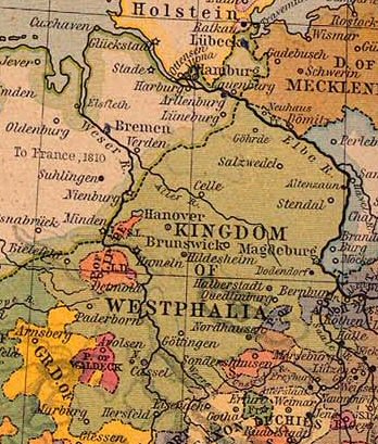
| Opis |
Nederlands: Koninkrijk Westfalen |
||||||||||||||||||||||
| Data | |||||||||||||||||||||||
| Źródło | From The Historical Atlas by William R. Shepherd, 1926. | ||||||||||||||||||||||
| Autor |
|
||||||||||||||||||||||
| Licencja (Ponowne użycie tego pliku) |
PCL states map is PD | ||||||||||||||||||||||
Licencja
Autor tej pracy zmarł w 1934 roku, więc ten materiał przeszedł do domeny publicznej w kraju pochodzenia, jak również w państwach i terytoriach, gdzie prawo autorskie wygasa w ciągu 80 lat po śmierci autora. | |
| Plik rozpoznano jako wolny od znanych ograniczeń praw autorskich, włącznie z prawami zależnymi i pokrewnymi. | |
This work is in the public domain because it was published in the United States between 1929 and 1963, and although there may or may not have been a copyright notice, the copyright was not renewed. For further explanation, see Commons:Hirtle chart and the copyright renewal logs. Note that it may still be copyrighted in jurisdictions that do not apply the rule of the shorter term for US works (depending on the date of the author's death), such as Canada (70 years p.m.a.), Mainland China (50 years p.m.a., not Hong Kong or Macao), Germany (70 years p.m.a.), Mexico (100 years p.m.a.), Switzerland (70 years p.m.a.), and other countries with individual treaties.
|
 |
Oryginalny rejestr przesyłania
- Originally from nl.wikipedia; description page is/was here.
(All user names refer to nl.wikipedia)
- 2004-08-16 09:49 Känsterle 348×409×8 (69732 bytes) Koninkrijk Westfalen - vrij te gebruiken voor educatieve doeleinden - http://www.lib.utexas.edu/maps/historical/
Map of the principality (later free state) of Lippe 1815–1945. From German Wikipedia and according to information there "Gemeinfrei" = public domain. {{PD-user|Störfix}}
Historia pliku
Kliknij na datę/czas, aby zobaczyć, jak plik wyglądał w tym czasie.
| Data i czas | Miniatura | Wymiary | Użytkownik | Opis | |
|---|---|---|---|---|---|
| aktualny | 11:38, 4 mar 2007 | | 348 × 409 (68 KB) | SieBot | {{Information |Description=Koninkrijk Westfalen {{PD-PCL|central_europe_1812.jpg|historical/shepherd/}} |Source=Originally from [http://nl.wikipedia.org nl.wikipedia]; description page is/was [http://nl.wikipedia.org/w/index.php?title=Image%3AKWestfale |
Lokalne wykorzystanie pliku
Żadna strona nie korzysta z tego pliku.
Globalne wykorzystanie pliku
Ten plik jest wykorzystywany także w innych projektach wiki:
- Wykorzystanie na ca.wikipedia.org
- Wykorzystanie na el.wikipedia.org
- Wykorzystanie na eo.wikipedia.org
- Wykorzystanie na et.wikipedia.org
- Wykorzystanie na fa.wikipedia.org
- Wykorzystanie na he.wikipedia.org
- Wykorzystanie na id.wikipedia.org
- Wykorzystanie na it.wikipedia.org
- Wykorzystanie na ro.wikipedia.org
- Wykorzystanie na sr.wikipedia.org
- Wykorzystanie na zh.wikipedia.org