
Plik:Map of plebiscite area.jpg
Map_of_plebiscite_area.jpg (499 × 593 pikseli, rozmiar pliku: 100 KB, typ MIME: image/jpeg)
| Plik Map of plebiscite area.jpg znajduje się w Wikimedia Commons – repozytorium wolnych zasobów. Dane z jego strony opisu znajdują się poniżej. |
Opis
| Opis |
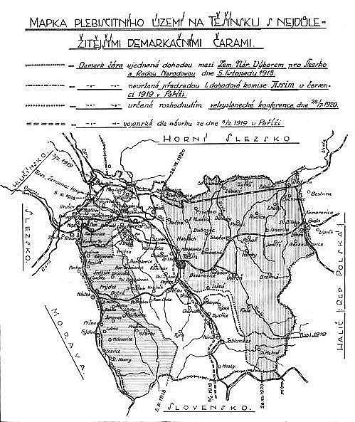
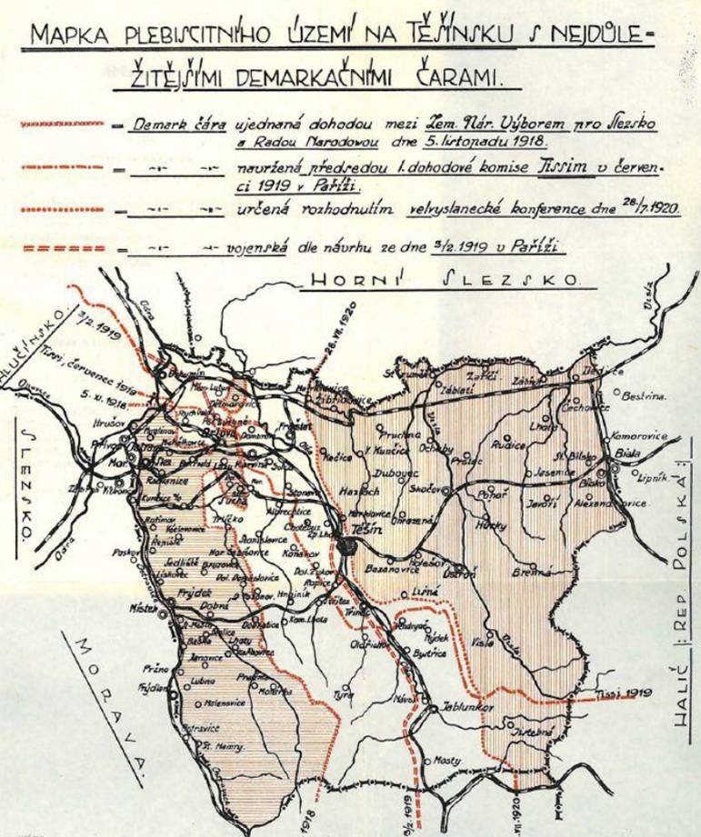
English: Map of the plebiscite area of Cieszyn Silesia during the dispute between Czechoslovakia and Poland over Teschen Silesia in 1918 - 1920. The descriptions on the map are in Czech. |
| Data | or before |
| Źródło | Dr. Ferdinand Pelc: O Těšínsko. Vzpomínky a úvahy, published by Slezská Matice osvěty lidové in Slezská Ostrava in 1928 |
| Autor | Nieznany |
| Inne wersje | higher resolution colour version with slightly cropped bottom |
Licencja
|
Ten materiał przeszedł do domeny publicznej w kraju pochodzenia, jak również w państwach i terytoriach, gdzie prawo autorskie wygasa w ciągu 70 lat po śmierci autora.
| |
| Plik rozpoznano jako wolny od znanych ograniczeń praw autorskich, włącznie z prawami zależnymi i pokrewnymi. | |
Historia pliku
Kliknij na datę/czas, aby zobaczyć, jak plik wyglądał w tym czasie.
| Data i czas | Miniatura | Wymiary | Użytkownik | Opis | |
|---|---|---|---|---|---|
| aktualny | 16:03, 14 sie 2008 | | 499 × 593 (100 KB) | MonkeymanT | {{Information |Description={{en|1=Map of the plebiscite area of Teschen Silesia during the dispute between Czechoslovakia and Poland over Teschen Silesia in 1918 - 1920. The descriptions on the map are in Czech.}} |Source=Dr. Ferdinand Pelc: O Těšínsko |
Lokalne wykorzystanie pliku
Żadna strona nie korzysta z tego pliku.
Globalne wykorzystanie pliku
Ten plik jest wykorzystywany także w innych projektach wiki:
- Wykorzystanie na cs.wikipedia.org
- Wykorzystanie na de.wikipedia.org
- Wykorzystanie na en.wikipedia.org
- Wykorzystanie na eo.wikipedia.org
- Wykorzystanie na es.wikipedia.org
- Wykorzystanie na it.wikipedia.org
- Wykorzystanie na ja.wikipedia.org
- Wykorzystanie na pt.wikipedia.org
- Wykorzystanie na ro.wikipedia.org
- Wykorzystanie na sh.wikipedia.org
- Wykorzystanie na sk.wikipedia.org
- Wykorzystanie na uk.wikipedia.org
- Wykorzystanie na www.wikidata.org