
Plik:Millennium Island, Kiribati.jpg
Rozmiar pierwotny (2832 × 4256 pikseli, rozmiar pliku: 6,48 MB, typ MIME: image/jpeg)
| Plik Millennium Island, Kiribati.jpg znajduje się w Wikimedia Commons – repozytorium wolnych zasobów. Dane z jego strony opisu znajdują się poniżej. |
Opis
| Opis |
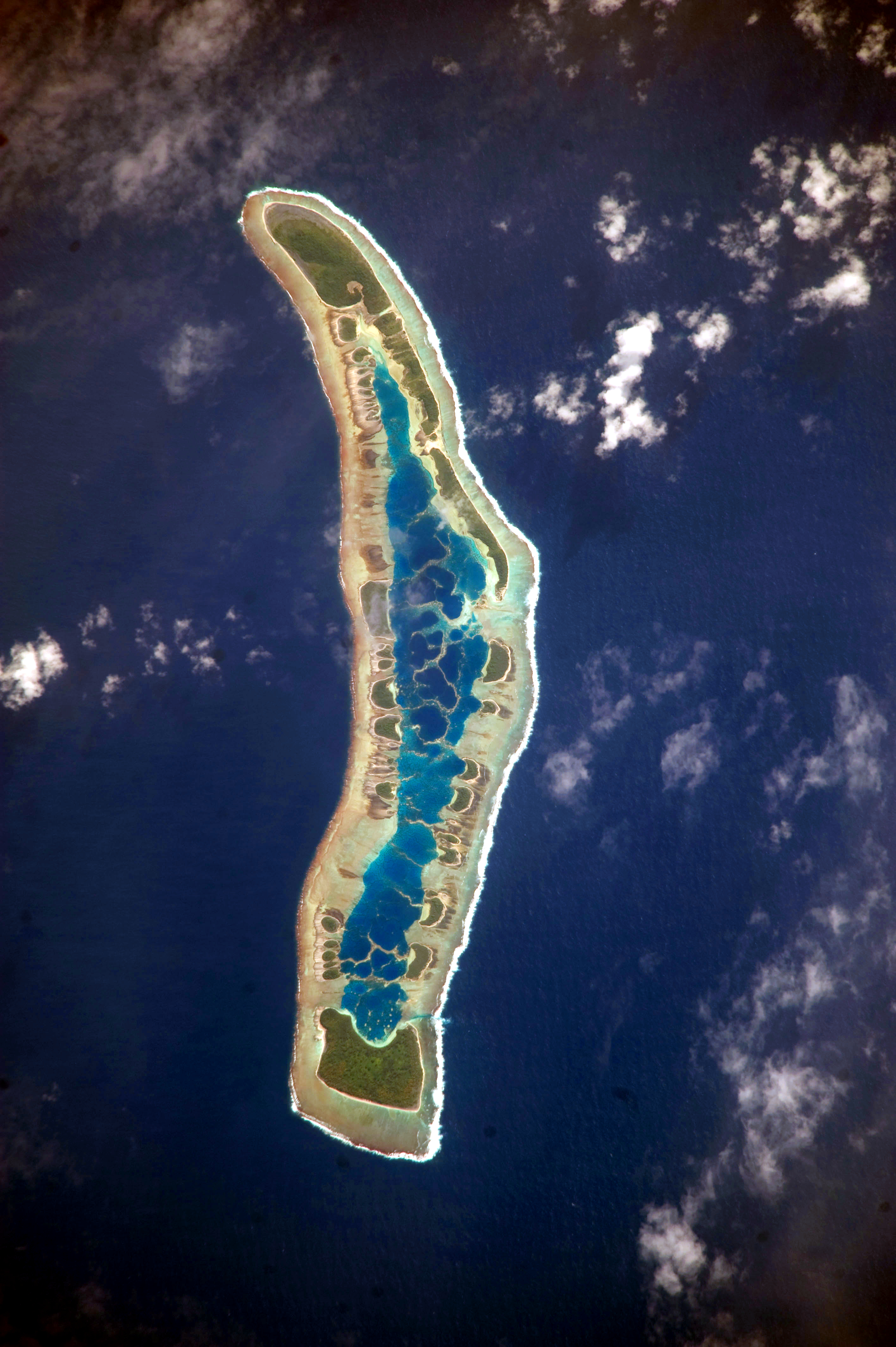
English: The islets of Millennium Island are readily visible in this astronaut photograph as irregular green vegetated areas surrounding the inner lagoon. The shallow lagoon waters are a lighter blue than the deeper surrounding ocean water; tan linear “fingers” within the lagoon are the tops of corals. The two largest islets are Nake Islet and South Islet, located at the north and south ends of Millennium Island respectively.
Français : Vue satellite de l'île du Millénaire dans les Kiribati, où l'on peut distinguer ses différents îlots, son lagon intérieur où des couleurs plus claires indiquent une profondeur plus faible ainsi que sa végétation dense sur certains îlots.
|
||||||||||||||||||||||||||||||||||||||||||||||||||||||
| Data | |||||||||||||||||||||||||||||||||||||||||||||||||||||||
| Źródło | NASA Earth Observatory | ||||||||||||||||||||||||||||||||||||||||||||||||||||||
| Autor | Image taken by the NASA Expedition 20 crew | ||||||||||||||||||||||||||||||||||||||||||||||||||||||
| Pozycja fotografa | | To i inne zdjęcia na: OpenStreetMap |
|---|
Ta grafika lub film został skatalagowany przez Johnson Space Center Stanów Zjednoczonych Ameryki National Aeronautics and Space Administration (NASA)pod Photo ID: ISS020-E-16279. Ten szablon nie wskazuje stanu prawnego pliku. Standardowy szablon licencji jest nadal wymagany. Aby dowiedzieć się więcej, zajrzyj na stronę Commons:Licencja. Inne języki:
|
This image was acquired with a Nikon D3 digital camera fitted with an 800 mm lens, and is provided by the ISS Crew Earth Observations experiment and Image Science & Analysis Laboratory, Johnson Space Center. Instrument: ISS - Digital Camera
Licencja
| Ten plik jest w domenie publicznej ponieważ został stworzony przez NASA. Polityka praw autorskich NASA stwierdza, że „materiały NASA nie są chronione prawami autorskimi, chyba że zapisano inaczej”. (NASA copyright policy lub JPL Image Use Policy). | ||
 |
Uwaga:
|
Historia pliku
Kliknij na datę/czas, aby zobaczyć, jak plik wyglądał w tym czasie.
| Data i czas | Miniatura | Wymiary | Użytkownik | Opis | |
|---|---|---|---|---|---|
| aktualny | 14:04, 13 cze 2017 | | 2832 × 4256 (6,48 MB) | SteinsplitterBot | Bot: Image rotated by 90° |
| 11:34, 5 paź 2010 |  | 4256 × 2832 (6,47 MB) | Originalwana | higher res | |
| 11:56, 13 lip 2009 |  | 1000 × 624 (486 KB) | Originalwana | {{Information |Description={{en|1=The islets of Millennium Island are readily visible in this astronaut photograph as irregular green vegetated areas surrounding the inner lagoon. The shallow lagoon waters are a lighter blue than the deeper surrounding oc |
Lokalne wykorzystanie pliku
Następujące strony korzystają z tego pliku:
Globalne wykorzystanie pliku
Ten plik jest wykorzystywany także w innych projektach wiki:
- Wykorzystanie na ar.wikipedia.org
- Wykorzystanie na be.wikipedia.org
- Wykorzystanie na ca.wikipedia.org
- Wykorzystanie na en.wikipedia.org
- Wykorzystanie na et.wikipedia.org
- Wykorzystanie na fr.wikipedia.org
- Wykorzystanie na hr.wikipedia.org
- Wykorzystanie na id.wikipedia.org
- Wykorzystanie na pt.wikipedia.org
- Wykorzystanie na ru.wikipedia.org
- Wykorzystanie na th.wikipedia.org
- Wykorzystanie na tr.wikipedia.org
- Wykorzystanie na vi.wikipedia.org