
Plik:North face marked.png
Grafika w wyższej rozdzielczości nie jest dostępna.
North_face_marked.png (720 × 540 pikseli, rozmiar pliku: 752 KB, typ MIME: image/png)
| Plik North face marked.png znajduje się w Wikimedia Commons – repozytorium wolnych zasobów. Dane z jego strony opisu znajdują się poniżej. |
Opis
| Opis |
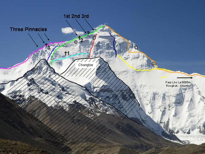
Deutsch: Nordwand des Mt. Everest, über zwei Vorgipfel hinweg aus dem Rongpu-Tal fotografert. Erklärung s. u.
English: North face of Mt. Everest as seen from the route to base camp, ascent routes marked. Description see below.
中文:從通往基地營的路看珠穆朗瑪峰的北面 |
| Data |
10 listopada 2008 (data pierwszego przesłania pliku) |
| Źródło | Derived from Image:Everest North Face toward Base Camp Tibet Luca Galuzzi 2006.jpg; routes and labels added by Kassander der Minoer. |
| Autor |
Luca Galuzzi - www.galuzzi.it Original uploader was User:Kassander der Minoer at de.wikipedia |
Bildlegende
Grüne Linie
|
Normalweg, in weiten Teilen die Mallory-Route 1924, mit Hochlagern auf ca. 7700 und 8300 m, heutiges 8300er Lager etwas mehr westlich (2 Dreiecke) |
Blaue Linie
|
Zakharov-Couloir |
hellblaue Linie
|
Querung Reinhold Messner vom Nordgrat zum Norton-Couloir 1980 ("Everest Solo by Fair Means") ohne O2 |
Rote Linie
|
Großes Couloir oder Norton-Couloir |
Lila Linie
|
kpl. Nordost-Grat mit Three Pinnacles; Japaner. Zuvor Russell Brice & Comp., aber nur lila Gratteil ohne Gipfel; Abstieg über Mallory-Linie |
Gelb und dunkelblau
|
Amerikaner 1963, "The West Ridge" |
Orange Linie
|
Jugoslawen 1979 |
Dunkelblaue Linie
|
Hornbein-Couloir |
| †1 | Mallory gefunden 1999 (Gräberfeld mit über 15 Toten lt. Conrad Anker) |
| †2 | 1st Step, Fundort Francys Arsentiev (Фрэнсис Арсентьев), "Green Boots", David Sharp (Дэвид Шарп) |
| †3 | 2nd Pinnacle, Fundort 1992 Peter Boardman (+1982) |
| ? | 2nd step, Fuß bei 8605m, ca. 30m hoch und ein 5-9/10er |
| ⓐ | Punkt ca. 8321m, bis zu dem George Ingle Finch mit Sauerstoff kam, 1922 |
| ⓑ | Punkt auf 8572m am Westrand des Couloirs, bis zu dem Edward Felix Norton 1924 ohne künstl. Sauerstoff kam (er zog das Klettern in der Wand vor, statt über den Grat zu gehen) |
| ⓒ | Gegend, die die Jugoslawen ausließen beim "kompletten Westgrat" 1979 |
| ⓓ | Gegend, in der die Amerikaner Tom Hornbein und Willi Unsoeld 1963 Schwierigkeiten bekamen und vom Westgrat in die Nordwand auswichen |
Legend
Green line
|
Standard route from north, mainly identical with Mallory's route in 1924; high camps on c.7700 m and 8300 m (indicated by two triangles), present day camp on 8300 m is located a bit further west. |
Navy blue line
|
Zakharov Couloir. |
Light blue line
|
Reinhold Messner's traverse from north ridge to Norton Couloir in 1980 ("Everest Solo by Fair Means") without supplemental oxygen. |
Red line
|
Great Couloir or Norton Couloir. |
Purple line
|
Complete northeast ridge with Three Pinnacles; Japanese route to the top. Climbed before by Russell Brice and Harry Taylor in 1988, but only the purple-marked part of the ridge, without going to the summit; descent via standard route. |
Yellow line and Dark blue line
|
American 1963, "The West Ridge". |
Orange line
|
Yugoslavian route, 1979. |
Dark blue line
|
Hornbein Couloir. |
| †1 | Resting place of Mallory's body, discovered in 1999 (graveyard with more than 15 bodies, according to Conrad Anker). |
| †2 | 1st Step, resting place of Francys Arsentiev, "Green Boots", David Sharp. |
| †3 | 2nd Pinnacle, resting place of Peter Boardman (1950 – 1982, discovered in 1992). |
| ? | 2nd step, base at 8605 m, c.30 m high, (difficulty: 5–9/10). |
| ⓐ | Point at ca. 8321 m, reached by George Ingle Finch with supplementary oxygen in 1922. |
| ⓑ | Point at 8572 m on the western side of the Couloir, reached by Edward Felix Norton 1924 without supplementary oxygen (Norton preferred climbing the wall rather than climbing the ridge). |
| ⓒ | Area left out by the Yugoslavian party on their "complete West Ridge" ascent in 1979. |
| ⓓ | Difficult area that forced Americans, Tom Hornbein and Willi Unsoeld, to traverse from the west ridge to the north face in 1963. |
Licencja
Ten plik udostępniony jest na licencji Creative Commons Uznanie autorstwa – Na tych samych warunkach 2.5.
- Wolno:
- dzielić się – kopiować, rozpowszechniać, odtwarzać i wykonywać utwór
- modyfikować – tworzyć utwory zależne
- Na następujących warunkach:
- uznanie autorstwa – musisz określić autorstwo utworu, podać link do licencji, a także wskazać czy utwór został zmieniony. Możesz to zrobić w każdy rozsądny sposób, o ile nie będzie to sugerować, że licencjodawca popiera Ciebie lub Twoje użycie utworu.
- na tych samych warunkach – Jeśli zmienia się lub przekształca niniejszy utwór, lub tworzy inny na jego podstawie, można rozpowszechniać powstały w ten sposób nowy utwór tylko na podstawie tej samej lub podobnej licencji.
Oryginalny rejestr przesyłania
Na Commons przeniósł z de.wikipedia użytkownik Rupert Pupkin z pomocą narzędzia CommonsHelper.
Oryginalna strona opisu była tutaj. Wszystkie poniższe nazwy użytkowników odwołują się do de.wikipedia.
- 2008-11-12 19:31 Kassander der Minoer 720×540× (770503 bytes) {{Information |Beschreibung = upgedatete Version |Quelle = Luca G. |Urheber = Luca G und eigene Malerei |Datum = 12-11-2008 |Genehmigung = |Andere Versionen = |Anmerkungen = siehe [[Benutzer_Diskussion:Rupert_Pupkin]] }}
- 2008-11-10 20:57 Kassander der Minoer 720×540× (758104 bytes) {{Information |Beschreibung = Nordwand des Mt. Everest, über zwei Vorgipfel hinweg aus dem Rongpu-Tal fotografert |Quelle = WP + KdM |Urheber = |Datum = 10.11.2008 |Genehmigung = jaaja, genehmigt. ;-) WIP = Work in Progress 4 discussion |Andere Versione
| Adnotacje | To zdjęcie jest opatrzone adnotacją: Zobacz adnotacje w Commons |
Historia pliku
Kliknij na datę/czas, aby zobaczyć, jak plik wyglądał w tym czasie.
| Data i czas | Miniatura | Wymiary | Użytkownik | Opis | |
|---|---|---|---|---|---|
| aktualny | 23:55, 26 lis 2008 | | 720 × 540 (752 KB) | File Upload Bot (Magnus Manske) | {{BotMoveToCommons|de.wikipedia}} {{Information |Description={{de|Nordwand des Mt. Everest, über zwei Vorgipfel hinweg aus dem Rongpu-Tal fotografert}} |Source=Transferred from [http://de.wikipedia.org de.wikipedia]; transferred to Commons by [[User:R |
Lokalne wykorzystanie pliku
Poniższa strona korzysta z tego pliku:
Globalne wykorzystanie pliku
Ten plik jest wykorzystywany także w innych projektach wiki:
- Wykorzystanie na bs.wikipedia.org
- Wykorzystanie na ca.wikipedia.org
- Wykorzystanie na de.wikipedia.org
- 4. Juni
- George Mallory
- Andrew Irvine
- Norton-Couloir
- Hornbein-Couloir
- Britische Mount-Everest-Expedition 1922
- Britische Mount-Everest-Expedition 1924
- Russell Brice
- Joe Tasker
- Frank Smythe
- Edward Felix Norton
- George Ingle Finch
- Peter Boardman
- Benutzer Diskussion:Rupert Pupkin/Alteisen
- Drei Felsstufen (Mount Everest)
- Portal:Berge und Gebirge/Ausgezeichnete Artikel
- Marco Siffredi
- Wykorzystanie na en.wikipedia.org
- Wykorzystanie na es.wikipedia.org
- Wykorzystanie na fr.wikipedia.org
- Wykorzystanie na hy.wikipedia.org
- Wykorzystanie na it.wikipedia.org
Pokaż listę globalnego wykorzystania tego pliku.