
Plik:Portugalliae 1561 (Baseado no primeiro mapa de Portugal)-JM.jpg

Rozmiar pierwotny (6048 × 4120 pikseli, rozmiar pliku: 8,4 MB, typ MIME: image/jpeg)
| Plik Portugalliae 1561 (Baseado no primeiro mapa de Portugal)-JM.jpg znajduje się w Wikimedia Commons – repozytorium wolnych zasobów. Dane z jego strony opisu znajdują się poniżej. |
Opis
- From portuguese wikipedia José Manuel CH--GE 14:34, 9 Novembro 2005 (UTC)
| Opis |
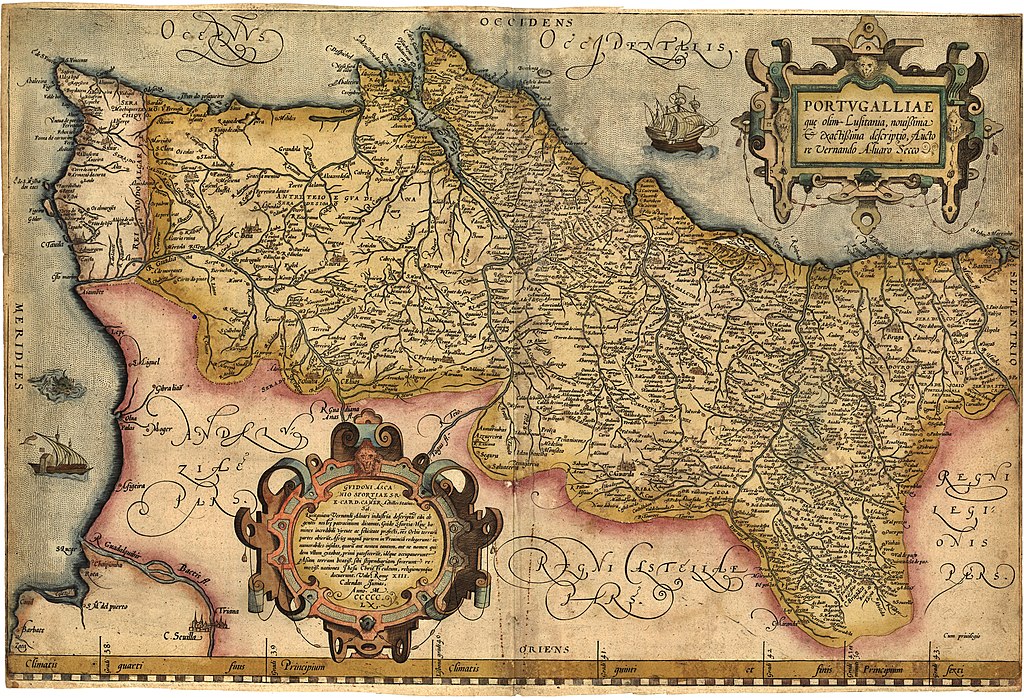
English: Portugalliae que olim Lusitania, novissima & exactissima descriptio. [1] Adaptation in the "Theatrum Orbis Terrarum" (1570) de Abraham Ortelius from the alleged first map of Portugal (1560) by Álvaro Seco. Português: Portugalliae que olim Lusitania, novissima & exactissima descriptio. [2] é provavelmente o primeiro mapa de Portugal. Feito por Álvaro Seco é provavelmente publicado em Roma por volta de 1560 com o título "Tabula Geografica Portugalliae". |
| Data | |
| Źródło | Praca własna |
| Autor | Jose Manuel |
| Inne wersje |
|
-JM_(pormenor_com_Troia).jpg)
_-_Geographicus_-_Portugalliae-ortelius-1587.jpg)


-JM.jpg)
Licencja
|
Ten materiał przeszedł do domeny publicznej w kraju pochodzenia, jak również w państwach i terytoriach, gdzie prawo autorskie wygasa w ciągu 70 lat po śmierci autora.
| |
| Plik rozpoznano jako wolny od znanych ograniczeń praw autorskich, włącznie z prawami zależnymi i pokrewnymi. | |
Historia pliku
Kliknij na datę/czas, aby zobaczyć, jak plik wyglądał w tym czasie.
| Data i czas | Miniatura | Wymiary | Użytkownik | Opis | |
|---|---|---|---|---|---|
| aktualny | 08:01, 13 gru 2018 | | 6048 × 4120 (8,4 MB) | SteinsplitterBot | Bot: Image rotated by 90° |
| 02:34, 11 sie 2012 |  | 4120 × 6054 (8,42 MB) | Jose Manuel | Best vertical photo resolution and sharp | |
| 01:04, 11 sie 2012 |  | 6054 × 4120 (21,47 MB) | Jose Manuel | Best photo resolution and sharp | |
| 17:26, 9 lis 2005 |  | 403 × 600 (94 KB) | Nuno Tavares | ;'''Description:''' :{{português}}: '' Portugalliae 1561 (Baseado no primeiro mapa de Portugal) " ;'''Source/Credits:''' : {{português}}: Fotografias Imagens ilustrações do usuário registrado. (''Não protegidos por copyright''). <br> :: Igualmente p |
Lokalne wykorzystanie pliku
Następujące strony korzystają z tego pliku:
Globalne wykorzystanie pliku
Ten plik jest wykorzystywany także w innych projektach wiki:
- Wykorzystanie na an.wikipedia.org
- Wykorzystanie na azb.wikipedia.org
- Wykorzystanie na be.wikipedia.org
- Wykorzystanie na ca.wikipedia.org
- Wykorzystanie na cs.wikipedia.org
- Wykorzystanie na de.wikipedia.org
- Wykorzystanie na en.wikipedia.org
- Wykorzystanie na eo.wikipedia.org
- Wykorzystanie na es.wikipedia.org
- Wykorzystanie na eu.wikipedia.org
- Wykorzystanie na fr.wikipedia.org
- Wykorzystanie na ga.wikipedia.org
- Wykorzystanie na gl.wikipedia.org
- Wykorzystanie na id.wikipedia.org
- Wykorzystanie na it.wikipedia.org
- Wykorzystanie na ml.wikipedia.org
- Wykorzystanie na ms.wikipedia.org
- Wykorzystanie na nl.wikipedia.org
- Wykorzystanie na nn.wikipedia.org
- Wykorzystanie na oc.wikipedia.org
- Wykorzystanie na pt.wikipedia.org
- Wykorzystanie na ru.wikipedia.org
- Wykorzystanie na sk.wikipedia.org
- Wykorzystanie na sv.wikipedia.org
- Wykorzystanie na uk.wikipedia.org
- Wykorzystanie na vi.wikipedia.org
- Wykorzystanie na www.wikidata.org
- Wykorzystanie na zh.wikipedia.org
-JM.jpg)