
Plik:Shoemaker Impact Structure, Western Australia.JPG
Rozmiar podglądu – 800 × 531 pikseli. Inne rozdzielczości: 320 × 213 pikseli | 640 × 425 pikseli | 1024 × 680 pikseli | 1280 × 850 pikseli | 2560 × 1700 pikseli | 4288 × 2848 pikseli.
Rozmiar pierwotny (4288 × 2848 pikseli, rozmiar pliku: 16,78 MB, typ MIME: image/jpeg)
| Plik Shoemaker Impact Structure, Western Australia.JPG znajduje się w Wikimedia Commons – repozytorium wolnych zasobów. Dane z jego strony opisu znajdują się poniżej. |
Opis
| Opis |
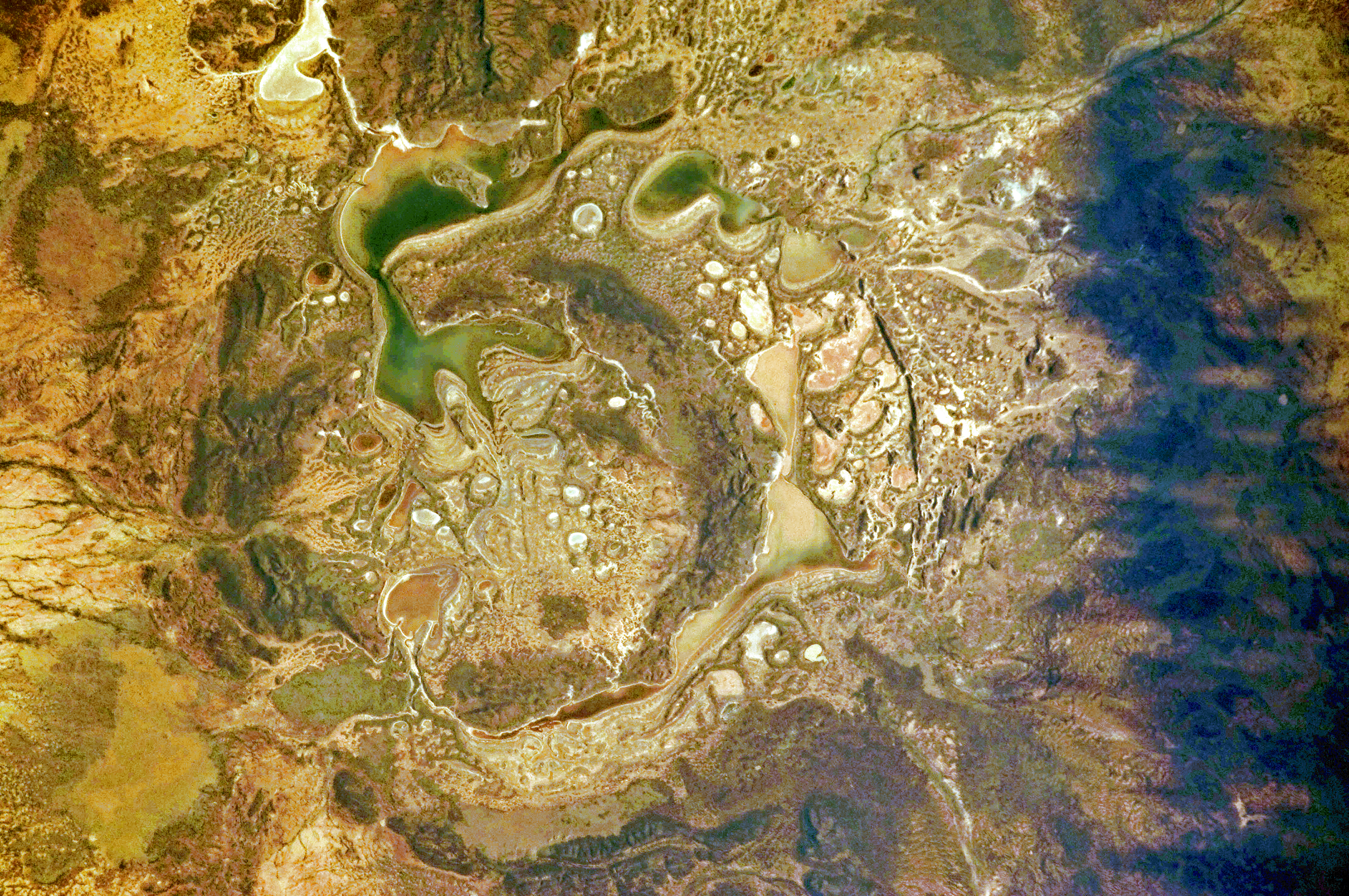
English: The Shoemaker impact site is approximately 30 kilometres in diameter and clearly defined by concentric ring structures formed in sedimentary rocks (brown to dark brown, image centre).
Several saline and ephemeral lakes—Nabberu, Teague, Shoemaker, and numerous smaller ponds—occupy the land surface between the ring structures. Differences in colour result from both water depth and from suspended sediments, with some bright salt crusts visible around the edges of smaller ponds (image centre). |
| Data | |
| Źródło | NASA Earth Observatory |
| Autor | ISS Expedition 28 crew |
| Pozycja fotografa | | To i inne zdjęcia na: OpenStreetMap |
|---|
Ta grafika lub film został skatalagowany przez Johnson Space Center Stanów Zjednoczonych Ameryki National Aeronautics and Space Administration (NASA)pod Photo ID: ISS028-E-14782. Ten szablon nie wskazuje stanu prawnego pliku. Standardowy szablon licencji jest nadal wymagany. Aby dowiedzieć się więcej, zajrzyj na stronę Commons:Licencja. Inne języki:
|
Image acquired with a Nikon D2Xs digital camera using a 200 mm lens, and is provided by the ISS Crew Earth Observations experiment and Image Science & Analysis Laboratory, Johnson Space Center.
Licencja
| Ten plik jest w domenie publicznej ponieważ został stworzony przez NASA. Polityka praw autorskich NASA stwierdza, że „materiały NASA nie są chronione prawami autorskimi, chyba że zapisano inaczej”. (NASA copyright policy lub JPL Image Use Policy). | ||
 |
Uwaga:
|
| Adnotacje | To zdjęcie jest opatrzone adnotacją: Zobacz adnotacje w Commons |
Historia pliku
Kliknij na datę/czas, aby zobaczyć, jak plik wyglądał w tym czasie.
| Data i czas | Miniatura | Wymiary | Użytkownik | Opis | |
|---|---|---|---|---|---|
| aktualny | 12:12, 19 lip 2011 | | 4288 × 2848 (16,78 MB) | Originalwana | {{Information |Description ={{en|1=The Shoemaker impact site is approximately 30 kilometres in diameter and clearly defined by concentric ring structures formed in sedimentary rocks (brown to dark brown, image centre). Several saline and ephemeral |
Lokalne wykorzystanie pliku
Następujące strony korzystają z tego pliku:
Globalne wykorzystanie pliku
Ten plik jest wykorzystywany także w innych projektach wiki:
- Wykorzystanie na en.wikipedia.org
- Wykorzystanie na ro.wikipedia.org
- Wykorzystanie na uk.wikipedia.org
- Wykorzystanie na www.wikidata.org
- Wykorzystanie na zh.wikipedia.org