
Plik:Wfm firth of forth.jpg

Rozmiar podglądu – 800 × 593 pikseli. Inne rozdzielczości: 320 × 237 pikseli | 640 × 474 pikseli | 1024 × 758 pikseli | 1280 × 948 pikseli.
Rozmiar pierwotny (1280 × 948 pikseli, rozmiar pliku: 289 KB, typ MIME: image/jpeg)
| Plik Wfm firth of forth.jpg znajduje się w Wikimedia Commons – repozytorium wolnych zasobów. Dane z jego strony opisu znajdują się poniżej. |
Opis
| Opis |
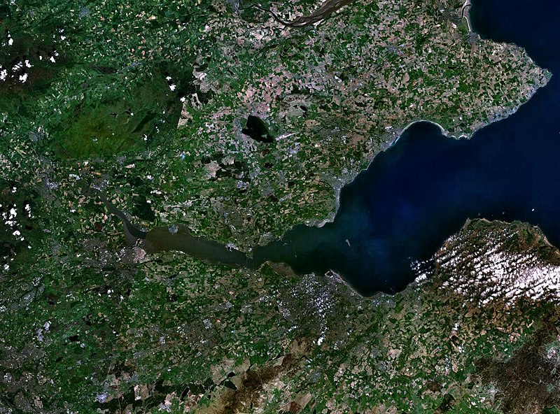
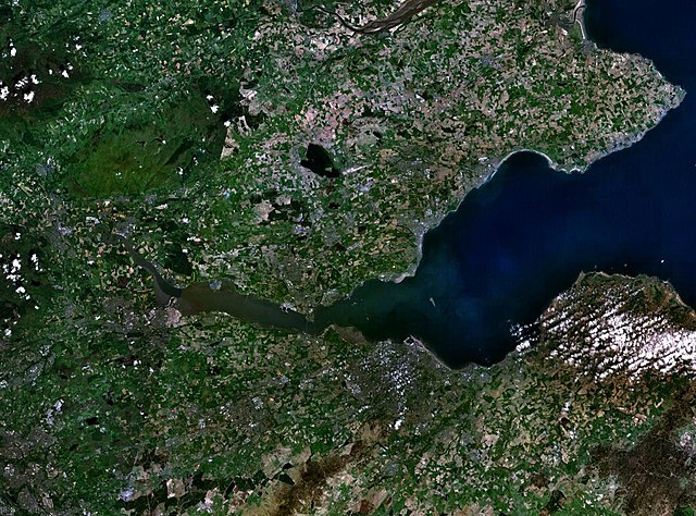
English: The Firth of the river Forth, on the east coast of Scotland. The two forth bridges are visible near the centre of the frame. Stirling is at the extreme left side. |
| Data | 3 sierpnia 2005 (data przesłania) |
| Źródło | Satellite imagery taken by screenshot from NASA World Wind software |
| Autor | NASA |
Licencja
| This image is in the public domain because it is a screenshot from NASA’s globe software World Wind using a public domain layer, such as Blue Marble, MODIS, Landsat, SRTM, USGS or GLOBE.
|
 |
Historia pliku
Kliknij na datę/czas, aby zobaczyć, jak plik wyglądał w tym czasie.
| Data i czas | Miniatura | Wymiary | Użytkownik | Opis | |
|---|---|---|---|---|---|
| aktualny | 11:38, 3 sie 2005 | | 1280 × 948 (289 KB) | Finlay McWalter | The Firth of the river Forth, on the east coast of Scotland. The two forth bridges are visible near the centre of the frame. Stirling is at the extreme left side. Image made with NASA World Wind. {{PD-USGov-NASA}} category:satellite photos |
Lokalne wykorzystanie pliku
Poniższa strona korzysta z tego pliku:
Globalne wykorzystanie pliku
Ten plik jest wykorzystywany także w innych projektach wiki:
- Wykorzystanie na ar.wikipedia.org
- Wykorzystanie na be.wikipedia.org
- Wykorzystanie na bg.wikipedia.org
- Wykorzystanie na br.wikipedia.org
- Wykorzystanie na ca.wikipedia.org
- Wykorzystanie na ceb.wikipedia.org
- Wykorzystanie na cs.wikipedia.org
- Wykorzystanie na cy.wikipedia.org
- Wykorzystanie na de.wikipedia.org
- Wykorzystanie na el.wikipedia.org
- Wykorzystanie na en.wikipedia.org
- Wykorzystanie na en.wikivoyage.org
- Wykorzystanie na eo.wikipedia.org
- Wykorzystanie na es.wikipedia.org
- Wykorzystanie na et.wikipedia.org
- Wykorzystanie na eu.wikipedia.org
- Wykorzystanie na fa.wikipedia.org
- Wykorzystanie na fr.wikipedia.org
- Wykorzystanie na ga.wikipedia.org
- Wykorzystanie na gd.wikipedia.org
- Wykorzystanie na ha.wikipedia.org
- Wykorzystanie na he.wikipedia.org
- Wykorzystanie na hi.wikipedia.org
- Wykorzystanie na ia.wikipedia.org
- Wykorzystanie na is.wikipedia.org
- Wykorzystanie na it.wikipedia.org
- Wykorzystanie na it.wikivoyage.org
- Wykorzystanie na ja.wikipedia.org
- Wykorzystanie na kbd.wikipedia.org
- Wykorzystanie na lt.wikipedia.org
- Wykorzystanie na mt.wikipedia.org
- Wykorzystanie na nl.wikipedia.org
- Wykorzystanie na nn.wikipedia.org
- Wykorzystanie na no.wikipedia.org
- Wykorzystanie na pt.wikipedia.org
- Wykorzystanie na ro.wikipedia.org
- Wykorzystanie na ru.wikipedia.org
- Wykorzystanie na sco.wikipedia.org
Pokaż listę globalnego wykorzystania tego pliku.