
Plik:Israel - Location Map (2012) - ISR - UNOCHA.svg

Rozmiar pierwotny (Plik SVG, nominalnie 250 × 250 pikseli, rozmiar pliku: 141 KB)
| Plik Israel - Location Map (2012) - ISR - UNOCHA.svg znajduje się w Wikimedia Commons – repozytorium wolnych zasobów. Dane z jego strony opisu znajdują się poniżej. |
Opis
| Opis |
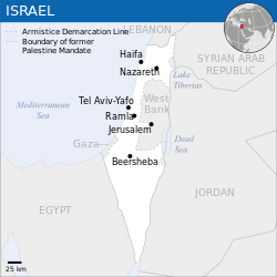
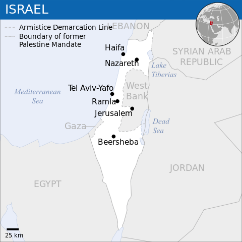
English: Locator map of Israel. العربية: خريطة إسرائيل. |
| Data | |
| Źródło |
English: [1], OCHA, UNCS |
| Autor | |
| Inne wersje |
|
| SVG rozwój |
_-_ISR_-_UNOCHA-ar.svg)
_-_ISR_-_UNOCHA-ur.svg)
_-_ISR_-_UNOCHA-zh.svg)
_-_ISR_-_UNOCHA-id.svg)
_-_ISR_-_UNOCHA.svg)
Licencja
- Wolno:
- dzielić się – kopiować, rozpowszechniać, odtwarzać i wykonywać utwór
- modyfikować – tworzyć utwory zależne
- Na następujących warunkach:
- uznanie autorstwa – musisz określić autorstwo utworu, podać link do licencji, a także wskazać czy utwór został zmieniony. Możesz to zrobić w każdy rozsądny sposób, o ile nie będzie to sugerować, że licencjodawca popiera Ciebie lub Twoje użycie utworu.
 This map is part of a collection of 216 free country maps, created by the UN Office for the Coordination of Humanitarian Affairs (OCHA), to be used in print, web or broadcast products.
The ReliefWeb Location Maps released here are maps that highlight a country, its capital, major populated places and the surrounding regions. Attribution Requirements
Using the map without modifications: ensure that the sources and the disclaimer are below the map. Credit as follows: "Credit: OCHA". For use with alteration: remove the OCHA logo and disclaimer following any modification to the map, but keep the data sources as mentioned below the map. Credit the modified map as follows: "Based on OCHA map". You are responsible for the content of your map. We are keen to receive your feedback and hear how you used OCHA's maps. We would be grateful if you would notify us by e-mail and share your work with us. UN Disclaimer
The designations employed and the presentation of material of this map do not imply the expression of any opinion whatsoever on the part of the Secretariat of the United Nations concerning the legal status of any country, territory, city or area or of its authorities or concerning the delimitation of its frontiers or boundaries. |

|
Textual information (e.g. timestamp) once visible in the image itself has been moved into the image metadata and/or image description page. This makes the image easier to reuse and more language-neutral, and makes the text easier to process and search for. Commons discourages placing visible textual information in images. All licenses accepted on Commons permit this type of modification as a derivative work.
If attribution information were removed and the image is not public domain, replace this tag with {{Attribution metadata from licensed image}}.
|
Historia pliku
Kliknij na datę/czas, aby zobaczyć, jak plik wyglądał w tym czasie.
| Data i czas | Miniatura | Wymiary | Użytkownik | Opis | |
|---|---|---|---|---|---|
| aktualny | 10:26, 8 paź 2023 | | 250 × 250 (141 KB) | Trần Nguyễn Minh Huy | File uploaded using svgtranslate tool (https://svgtranslate.toolforge.org/). Added translation for vi. |
| 08:39, 27 lip 2022 |  | 250 × 250 (140 KB) | Enkhsaihan2005 | File uploaded using svgtranslate tool (https://svgtranslate.toolforge.org/). Added translation for mn. | |
| 08:38, 27 lip 2022 |  | 250 × 250 (139 KB) | Enkhsaihan2005 | File uploaded using svgtranslate tool (https://svgtranslate.toolforge.org/). Added translation for mn. | |
| 03:48, 28 mar 2022 |  | 250 × 250 (136 KB) | Nyilvoskt | File uploaded using svgtranslate tool (https://svgtranslate.toolforge.org/). Added translation for id. | |
| 17:21, 17 lut 2022 |  | 250 × 250 (134 KB) | Kurmanbek | File uploaded using svgtranslate tool (https://svgtranslate.toolforge.org/). Added translation for tr. | |
| 00:27, 18 lut 2016 |  | 250 × 250 (130 KB) | Wereldburger758 | Resized page to drawing. Removal watermark. Validation of image. | |
| 05:21, 19 sie 2014 |  | 250 × 250 (185 KB) | Pharos | == {{int:filedesc}} == {{Information |description={{en|1=Locator map of Chile.}} |date=2013 |source={{en|1=[http://reliefweb.int/map/chile/chile-location-map-2013 Chile Locator Map (ReliefWeb)]}} |author={{en|1=[[w:en:United Nations Offi... |
Lokalne wykorzystanie pliku
Żadna strona nie korzysta z tego pliku.
Globalne wykorzystanie pliku
Ten plik jest wykorzystywany także w innych projektach wiki:
- Wykorzystanie na ar.wikipedia.org
- Wykorzystanie na az.wikipedia.org
- Wykorzystanie na ban.wikipedia.org
- Wykorzystanie na bcl.wikipedia.org
- Wykorzystanie na bh.wikipedia.org
- Wykorzystanie na blk.wikipedia.org
- Wykorzystanie na bxr.wikipedia.org
- Wykorzystanie na dty.wikipedia.org
- Wykorzystanie na en.wikipedia.org
- Wykorzystanie na es.wikipedia.org
- Wykorzystanie na eu.wikipedia.org
- Wykorzystanie na fa.wikipedia.org
- Wykorzystanie na fr.wikipedia.org
- Wykorzystanie na gu.wikipedia.org
- Wykorzystanie na hy.wikipedia.org
- Wykorzystanie na id.wikipedia.org
- Wykorzystanie na incubator.wikimedia.org
- Wykorzystanie na ka.wikipedia.org
- Wykorzystanie na lo.wikipedia.org
- Wykorzystanie na ml.wikipedia.org
- Wykorzystanie na mn.wikipedia.org
- Wykorzystanie na mzn.wikipedia.org
- Wykorzystanie na ne.wikipedia.org
- Wykorzystanie na nso.wikipedia.org
- Wykorzystanie na pa.wikipedia.org
- Wykorzystanie na pnb.wikipedia.org
- Wykorzystanie na ro.wikipedia.org
- Wykorzystanie na ru.wikipedia.org
- Wykorzystanie na sco.wikipedia.org
- Wykorzystanie na sd.wikipedia.org
- Wykorzystanie na si.wikipedia.org
- Wykorzystanie na sl.wikipedia.org
- Wykorzystanie na sq.wikipedia.org
- Wykorzystanie na su.wikipedia.org
- Wykorzystanie na tcy.wikipedia.org
- Wykorzystanie na te.wikipedia.org
- Wykorzystanie na th.wikipedia.org
- Wykorzystanie na to.wikipedia.org
- Wykorzystanie na tr.wikipedia.org
Pokaż listę globalnego wykorzystania tego pliku.
_-_ISR_-_UNOCHA.svg)
_-_ISR_-_UNOCHA.svg)