
Plik:Meghalaya COVID-19.svg

Wielkość pliku podglądu PNG dla pliku SVG: 800 × 430 pikseli Inne rozdzielczości: 320 × 172 pikseli | 640 × 344 pikseli | 1024 × 551 pikseli | 1280 × 688 pikseli | 2560 × 1377 pikseli | 807 × 434 pikseli.
Rozmiar pierwotny (Plik SVG, nominalnie 807 × 434 pikseli, rozmiar pliku: 157 KB)
| Plik Meghalaya COVID-19.svg znajduje się w Wikimedia Commons – repozytorium wolnych zasobów. Dane z jego strony opisu znajdują się poniżej. |
Opis
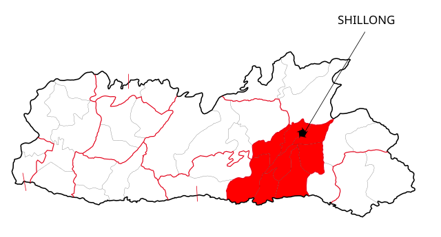
| Opis | This file shows the districts of Meghalaya affected by COVID-19. |
| Data | |
| Źródło | Meghalaya 2012.svg |
| Autor | Nilabh |
| Inne wersje |
[]
|


Licencja
Ja, właściciel praw autorskich do tego dzieła, udostępniam je na poniższych licencjach
Ten plik udostępniony jest na licencji Creative Commons Uznanie autorstwa – Na tych samych warunkach 4.0 Międzynarodowe.
- Wolno:
- dzielić się – kopiować, rozpowszechniać, odtwarzać i wykonywać utwór
- modyfikować – tworzyć utwory zależne
- Na następujących warunkach:
- uznanie autorstwa – musisz określić autorstwo utworu, podać link do licencji, a także wskazać czy utwór został zmieniony. Możesz to zrobić w każdy rozsądny sposób, o ile nie będzie to sugerować, że licencjodawca popiera Ciebie lub Twoje użycie utworu.
- na tych samych warunkach – Jeśli zmienia się lub przekształca niniejszy utwór, lub tworzy inny na jego podstawie, można rozpowszechniać powstały w ten sposób nowy utwór tylko na podstawie tej samej lub podobnej licencji.

|
Udziela się zgody na kopiowanie, rozpowszechnianie oraz modyfikowanie tego dokumentu zgodnie z warunkami GNU Licencji Wolnej Dokumentacji, w wersji 1.2 lub nowszej opublikowanej przez Free Software Foundation; bez niezmiennych sekcji, bez treści umieszczonych na frontowej lub tylnej stronie okładki. Kopia licencji załączona jest w sekcji zatytułowanej GNU Licencja Wolnej Dokumentacji. |
Możesz wybrać, którą licencję chcesz zastosować.
Historia pliku
Kliknij na datę/czas, aby zobaczyć, jak plik wyglądał w tym czasie.
| Data i czas | Miniatura | Wymiary | Użytkownik | Opis | |
|---|---|---|---|---|---|
| aktualny | 14:41, 13 maj 2020 | | 807 × 434 (157 KB) | Nilabh Shivam 333 | {{Information |description={{en|1=Districts with confirmed cases in the state of meghalaya, '''as of 12 May 2020'''.}} {{legend|#FF6347|10+ confirmed cases reported}} [https://web.archive.org/web/20040606141014/www.censusindia.net/results/2001maps/assam01.html]. Note: * This map does not show the newer districts that were created after 2014. * The new districts are Chirag, Baksa, Odalguri and Kamrup Metropolitan |Source={{Derived from|Meghalaya 2012.svg|display=50}} |Date=2020-05-13 18:34 (U... |
| 20:31, 4 kwi 2020 |  | 631 × 530 (348 KB) | Firos ak | == {{int:filedesc}} == {{Information |Description={{en|1=This file shows the districts of en:Assam as of 2001. The map is based on a free hand trace of [https://web.archive.org/web/20040606141014/www.censusindia.net/results/2001maps/assam01.html]. Note: * This map does not show the newer districts that were created after 2001. * The new districts are Chirag, Baksa, Odalguri and Kamrup Metropolitan}} |Source={{Derived from|Assam-districts-2001.svg|display=50}} |Date=2020-04-04 18:31 (UT... | |
| 01:27, 20 sie 2011 |  | 631 × 530 (211 KB) | Chaipau | Corrected the following districts: Nalbari, Barpeta, Sivasagar, Tinsukia | |
| 13:02, 5 kwi 2009 |  | 631 × 530 (165 KB) | Chaipau | The image is cropped to exclude empty spaces. | |
| 03:14, 5 kwi 2009 |  | 744 × 1052 (165 KB) | Chaipau | {{Information |Description={{en|1=This file shows the districts of en:Assam as of 2001. The map is based on a free hand trace of [http://web.archive.org/web/20040606141014/www.censusindia.net/results/2001maps/assam01.html]. Note: * This map does not |
Lokalne wykorzystanie pliku
Żadna strona nie korzysta z tego pliku.
Globalne wykorzystanie pliku
Ten plik jest wykorzystywany także w innych projektach wiki:
- Wykorzystanie na awa.wikipedia.org
- Wykorzystanie na ca.wikipedia.org
- Wykorzystanie na eu.wikipedia.org
- Wykorzystanie na hi.wikipedia.org
- असम
- दरंग जिला
- बंगाईगाँव जिला
- नलबाड़ी जिला
- जोरहाट जिला
- कार्बी आंगलोंग जिला
- कामरूप जिला
- कोकराझार जिला
- बरपेटा जिला
- डिब्रूगढ़ जिला
- धेमाजी जिला
- धुबरी जिला
- तिनसुकिया जिला
- गोवालपारा जिला
- लखीमपुर जिला
- भारत के ज़िले
- डिमा हासाओ जिला
- करीमगंज जिला
- गोलाघाट जिला
- नगाँव जिला
- मरिगाँव जिला
- शिवसागर जिला
- शोणितपुर जिला
- हाईलाकांदी जिला
- काछार जिला
- चिरांग जिला
- बाक्सा जिला
- उदलगुड़ी जिला
- कामरूप महानगर जिला
- विश्वनाथ जिला
- होजाई जिला
- चराईदेव जिला
- माजुली जिला
- Wykorzystanie na kk.wikipedia.org
- Wykorzystanie na mai.wikipedia.org
Pokaż listę globalnego wykorzystania tego pliku.