
Plik:Battle of Ballinamuck, 1798 (9675655157).jpg

Rozmiar pierwotny (2500 × 1859 pikseli, rozmiar pliku: 1,41 MB, typ MIME: image/jpeg)
| Plik Battle of Ballinamuck, 1798 (9675655157).jpg znajduje się w Wikimedia Commons – repozytorium wolnych zasobów. Dane z jego strony opisu znajdują się poniżej. |
.jpg)
Opis
| Opis |
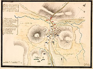
For those of you who like your maps, this is a watercolour plan by an I. Hardy of the Battle of Ballinamuck in Co. Longford showing Position of the English & French Armies previous to the Surrender of the latter at Balinamuck ... 8th September 1798. [It is also, to my shame, the first Longford image on our Commons photostream - something I hope to rectify!] Artist: I. Hardy Date: Circa 1798 Size: 26 x 19.3 cm on sheet 30.3 x 23.7 cm NLI Ref.: PD HP (1798) 20 |
| Źródło |
|
| Autor | Library of Ireland on The Commons @ Flickr Commons |
| Pozycja fotografa | | To i inne zdjęcia na: OpenStreetMap |
|---|
.jpg¶ms=053.866661_N_-007.716670_E_globe:Earth_type:camera_source:Flickr_&language=pl)
Licencja
This image was taken from Flickr's The Commons. The uploading organization may have various reasons for determining that no known copyright restrictions exist, such as:
More information can be found at https://flickr.com/commons/usage/. Please add additional copyright tags to this image if more specific information about copyright status can be determined. See Commons:Licensing for more information. |
| Ten plik, opublikowany pierwotnie w serwisie Flickr, został przejrzany 5 września 2013 przez administratora lub zaufanego użytkownika File Upload Bot (Magnus Manske), który stwierdził, że jest on dostępny w serwisie Flickr pod powyższą licencją. |
Historia pliku
Kliknij na datę/czas, aby zobaczyć, jak plik wyglądał w tym czasie.
| Data i czas | Miniatura | Wymiary | Użytkownik | Opis | |
|---|---|---|---|---|---|
| aktualny | 12:21, 5 wrz 2013 | | 2500 × 1859 (1,41 MB) | File Upload Bot (Magnus Manske) | Transferred from Flickr by User:guliolopez |
Lokalne wykorzystanie pliku
Poniższa strona korzysta z tego pliku:
Globalne wykorzystanie pliku
Ten plik jest wykorzystywany także w innych projektach wiki:
- Wykorzystanie na en.wikipedia.org
- Wykorzystanie na fr.wikipedia.org
- Wykorzystanie na ga.wikipedia.org
- Wykorzystanie na it.wikipedia.org
- Wykorzystanie na www.wikidata.org
.jpg)