
Plik:E1-Maale Adumim-annexation-plan-2005.png

Rozmiar pierwotny (14 033 × 9920 pikseli, rozmiar pliku: 3,25 MB, typ MIME: image/png)
| Plik E1-Maale Adumim-annexation-plan-2005.png znajduje się w Wikimedia Commons – repozytorium wolnych zasobów. Dane z jego strony opisu znajdują się poniżej. |
Opis
| Opis |
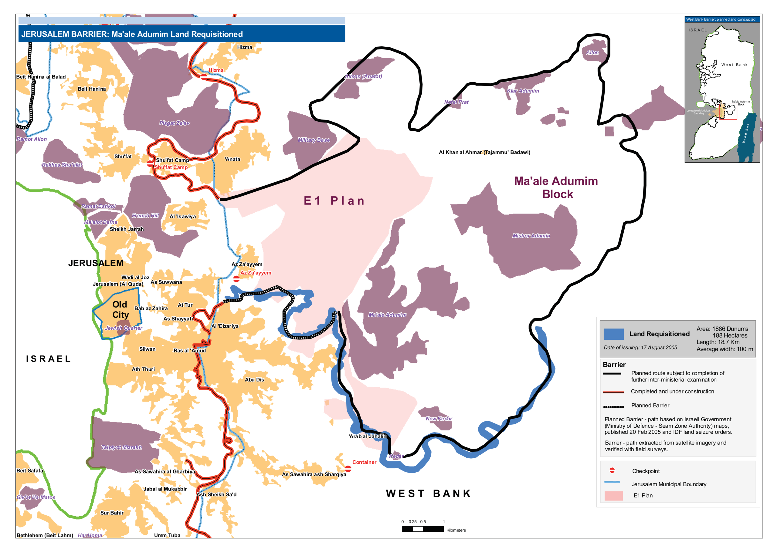
English: Map of E1 Plan and Ma'ale Adumim settlement in East Jerusalem with planned Jerusalem Barrier, August 2005 This map was published after the Israeli occupation authorities on 17 August 2005 had issued four military requisitions orders for Barrier construction near and around Ma’ale Adumim, stealing approximately 1,600 dunums of Palestinian land. |
| Data | |
| Źródło |
Praca własna. Based on Occupied Palestinian Territories - Jerusalem Barrier: Ma'ale Adumim land requisitioned (graphic map) |
| Autor | Wickey |
Licencja
- Wolno:
- dzielić się – kopiować, rozpowszechniać, odtwarzać i wykonywać utwór
- modyfikować – tworzyć utwory zależne
- Na następujących warunkach:
- uznanie autorstwa – musisz określić autorstwo utworu, podać link do licencji, a także wskazać czy utwór został zmieniony. Możesz to zrobić w każdy rozsądny sposób, o ile nie będzie to sugerować, że licencjodawca popiera Ciebie lub Twoje użycie utworu.
- na tych samych warunkach – Jeśli zmienia się lub przekształca niniejszy utwór, lub tworzy inny na jego podstawie, można rozpowszechniać powstały w ten sposób nowy utwór tylko na podstawie tej samej lub podobnej licencji.
| This image is a map derived from a United Nations map.
Unless stated otherwise, UN maps are to be considered in the public domain. This applies worldwide. UN maps are, in principle, open source material and you can use them in your work or for making your own map. UN requests however that you delete the UN name, logo and reference number upon any modification to the map. Content of your map will be your responsibility. You can state in your publication, if you wish, something like: based on UN map … (map name, map number, revision number and date). See: Geospatial Information Section. And: Geospatial, location data for a better world. |
 |
Historia pliku
Kliknij na datę/czas, aby zobaczyć, jak plik wyglądał w tym czasie.
| Data i czas | Miniatura | Wymiary | Użytkownik | Opis | |
|---|---|---|---|---|---|
| aktualny | 05:58, 6 maj 2020 | | 14 033 × 9920 (3,25 MB) | Wickey | Uploaded own work with UploadWizard |
Lokalne wykorzystanie pliku
Poniższa strona korzysta z tego pliku:
Globalne wykorzystanie pliku
Ten plik jest wykorzystywany także w innych projektach wiki:
- Wykorzystanie na nl.wikipedia.org