
Plik:EIA World Shale Gas Map-en.svg

Wielkość pliku podglądu PNG dla pliku SVG: 636 × 318 pikseli Inne rozdzielczości: 320 × 160 pikseli | 640 × 320 pikseli | 1024 × 512 pikseli | 1280 × 640 pikseli | 2560 × 1280 pikseli.
Rozmiar pierwotny (Plik SVG, nominalnie 636 × 318 pikseli, rozmiar pliku: 1,97 MB)
| Plik EIA World Shale Gas Map-en.svg znajduje się w Wikimedia Commons – repozytorium wolnych zasobów. Dane z jego strony opisu znajdują się poniżej. |
Opis
| Opis |
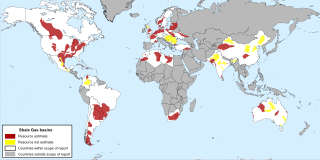
English: Map of major shale gas basins all over the world from the EIA report World Shale Gas Resources: An Initial Assessment of 14 Regions Outside the United States . |
| Data | |
| Źródło | http://www.eia.gov/analysis/studies/worldshalegas/ |
| Autor | Energy Information Administration |
| Inne wersje |
|


Licencja
| This image is a work of a United States Department of Energy (or predecessor organization) employee, taken or made as part of that person's official duties. As a work of the U.S. federal government, the image is in the public domain.
Please note that national laboratories operate under varying licences and some are not free. Check the site policies of any national lab before crediting it with this tag.
|

|
Historia pliku
Kliknij na datę/czas, aby zobaczyć, jak plik wyglądał w tym czasie.
| Data i czas | Miniatura | Wymiary | Użytkownik | Opis | |
|---|---|---|---|---|---|
| aktualny | 18:11, 8 paź 2013 | | 636 × 318 (1,97 MB) | Fulvio314 | {{Information |Description ={{en|1=Map of major shale gas basis all over the world from the EIA report ''World Shale Gas Resources: An Initial Assessment of 14 Regions Outside the United States ''.}} |Source =http://www.eia.gov/analysis/stud... |
Lokalne wykorzystanie pliku
Poniższa strona korzysta z tego pliku:
Globalne wykorzystanie pliku
Ten plik jest wykorzystywany także w innych projektach wiki:
- Wykorzystanie na ar.wikipedia.org
- Wykorzystanie na be-tarask.wikipedia.org
- Wykorzystanie na bn.wikipedia.org
- Wykorzystanie na ca.wikipedia.org
- Wykorzystanie na cs.wikipedia.org
- Wykorzystanie na cv.wikipedia.org
- Wykorzystanie na da.wikipedia.org
- Wykorzystanie na de.wikipedia.org
- Wykorzystanie na en.wikipedia.org
- Wykorzystanie na et.wikipedia.org
- Wykorzystanie na eu.wikipedia.org
- Wykorzystanie na fa.wikipedia.org
- Wykorzystanie na fr.wikipedia.org
- Wykorzystanie na hi.wikipedia.org
- Wykorzystanie na hu.wikipedia.org
- Wykorzystanie na id.wikipedia.org
- Wykorzystanie na it.wikipedia.org
- Wykorzystanie na ja.wikipedia.org
- Wykorzystanie na lt.wikipedia.org
- Wykorzystanie na ml.wikipedia.org
- Wykorzystanie na nl.wikipedia.org
- Wykorzystanie na no.wikipedia.org
- Wykorzystanie na pt.wikipedia.org
- Wykorzystanie na ro.wikipedia.org
- Wykorzystanie na ru.wikipedia.org
- Wykorzystanie na ta.wikipedia.org
- Wykorzystanie na tr.wikipedia.org
- Wykorzystanie na uk.wikipedia.org
- Wykorzystanie na ur.wikipedia.org
- Wykorzystanie na zh-min-nan.wikipedia.org