
Plik:First Republic of Armenia in 1918-1920.png

Rozmiar podglądu – 799 × 348 pikseli. Inne rozdzielczości: 320 × 139 pikseli | 640 × 279 pikseli | 1024 × 446 pikseli | 1280 × 558 pikseli | 2560 × 1115 pikseli | 8192 × 3568 pikseli.
Rozmiar pierwotny (8192 × 3568 pikseli, rozmiar pliku: 14,85 MB, typ MIME: image/png)
| Plik First Republic of Armenia in 1918-1920.png znajduje się w Wikimedia Commons – repozytorium wolnych zasobów. Dane z jego strony opisu znajdują się poniżej. |
Opis
| Opis |
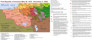
English: The First Republic of Armenia in 1918-1920. |
| Data | |
| Źródło | Praca własna |
| Autor | Accipite7 |
Licencja
Ja, właściciel praw autorskich do tego dzieła, udostępniam je na poniższej licencji
Ten plik udostępniony jest na licencji Creative Commons Uznanie autorstwa – Na tych samych warunkach 4.0 Międzynarodowe.
- Wolno:
- dzielić się – kopiować, rozpowszechniać, odtwarzać i wykonywać utwór
- modyfikować – tworzyć utwory zależne
- Na następujących warunkach:
- uznanie autorstwa – musisz określić autorstwo utworu, podać link do licencji, a także wskazać czy utwór został zmieniony. Możesz to zrobić w każdy rozsądny sposób, o ile nie będzie to sugerować, że licencjodawca popiera Ciebie lub Twoje użycie utworu.
- na tych samych warunkach – Jeśli zmienia się lub przekształca niniejszy utwór, lub tworzy inny na jego podstawie, można rozpowszechniać powstały w ten sposób nowy utwór tylko na podstawie tej samej lub podobnej licencji.
Historia pliku
Kliknij na datę/czas, aby zobaczyć, jak plik wyglądał w tym czasie.
| Data i czas | Miniatura | Wymiary | Użytkownik | Opis | |
|---|---|---|---|---|---|
| aktualny | 17:13, 2 cze 2021 | | 8192 × 3568 (14,85 MB) | Accipite7 | for the convenience of viewing small details, the size is increased, the colors are improved |
| 10:17, 25 maj 2021 |  | 4096 × 1784 (3,69 MB) | Accipite7 | The border between Nahang of Shirak and Nahang of Syunik has been clarified. | |
| 11:59, 21 maj 2021 |  | 4096 × 1784 (3,7 MB) | Accipite7 | The temporary border between the Republic of Armenia and the Soviet republics (August 10, 1920) in the Nakhichevan county has been clarified. Added a legend marked on the map under the number 26. | |
| 10:35, 13 maj 2021 |  | 4096 × 1784 (3,97 MB) | Accipite7 | fixed typo | |
| 10:27, 13 maj 2021 |  | 4096 × 1784 (3,97 MB) | Accipite7 | The names of the types of administrative units of the former Russian Empire have been clarified: uyezd = county, okrug = district, oblast = territory, guberniya = governorate. | |
| 13:14, 12 maj 2021 |  | 4096 × 1784 (3,71 MB) | Accipite7 | Corrected data in the map legend regarding what is indicated on the map by numbers. Clarified the boundaries of the territories required at the Paris Peace Conference. I strongly ask the user of Culminatio not to vandalize and not return the map to the version on which he marked the line reached as a result of the Turkish offensive in 1920. Since, firstly, it is neural: Batumi, Artvin and Ardahan were under the control of the Democratic Republic of Georgia until February-March 1921. And secon... | |
| 06:13, 12 maj 2021 |  | 5375 × 2341 (7,18 MB) | Culminatio | Reverted to version as of 15:05, 8 May 2021 (UTC) | |
| 09:11, 11 maj 2021 |  | 4096 × 1784 (3,99 MB) | Accipite7 | The boundaries of the territory of the demands of the Armenian delegation in the Transcaucasus, submitted to the Paris Peace Conference of 1919, were clarified. There is no need to overload the map with the line reached by the Turkish forces in 1920, as the map already shows the results of the Armenian-Turkish war of 1920 - the border according to the Treaty of Alexandropol, December 2, 1920 | |
| 17:05, 8 maj 2021 |  | 5375 × 2341 (7,18 MB) | Culminatio | Additional line of the turkish advance on the northern positions during the war of 1920. Additional numbers 10,19,20,21 on the map. | |
| 12:49, 8 maj 2021 |  | 6336 × 2760 (2,21 MB) | Accipite7 | Improved colors. |
Lokalne wykorzystanie pliku
Następujące strony korzystają z tego pliku:
Globalne wykorzystanie pliku
Ten plik jest wykorzystywany także w innych projektach wiki:
- Wykorzystanie na az.wikipedia.org
- Wykorzystanie na be.wikipedia.org
- Wykorzystanie na bg.wikipedia.org
- Wykorzystanie na de.wikipedia.org
- Wykorzystanie na el.wikipedia.org
- Wykorzystanie na fi.wikipedia.org
- Wykorzystanie na fr.wikipedia.org
- Wykorzystanie na hy.wikipedia.org
- Wykorzystanie na it.wikipedia.org
- Wykorzystanie na nl.wikipedia.org
- Wykorzystanie na pt.wikipedia.org
- Wykorzystanie na ro.wikipedia.org
- Wykorzystanie na ru.wikipedia.org
- Wykorzystanie na sr.wikipedia.org
- Wykorzystanie na uk.wikipedia.org
- Wykorzystanie na zh.wikipedia.org