Plik:Floridakeys-nasa.jpg
Treść strony nie jest dostępna w innych językach.
Ten plik jest umieszczony w Wikimedia Commons
Z Wikipedii, wolnej encyklopedii

Rozmiar pierwotny(1400 × 1000 pikseli, rozmiar pliku: 215 KB, typ MIME: image/jpeg)

Opis

Opis
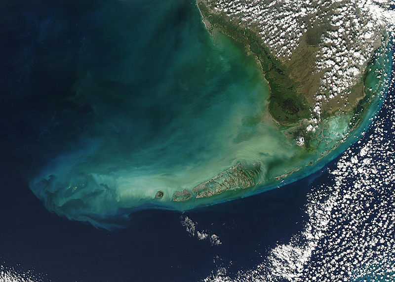
English: Turbid waters surround southern Florida and the Florida Keys in this true-color Moderate Resolution Imaging Spectroradiometer (MODIS) image taken by the Aqua satellite on December 2, 2003. Clouds of milky blue, green, and tan sediments and microscopic marine organisms (like phytoplankton and algae) discolor the water in the Gulf of Mexico north of the Keys, but end abruptly in the deeper water of the Straits of Florida. The water north of the Keys is relatively shallow, so sediments are a likely cause of the discoloration—rough waters can churn up the mud from the sea floor, which then clouds the water. But in the deeper water south of the Keys, sediment on the sea floor is much harder to disturb, which keeps the water clearer.

The Keys are a collection of islands, islets, and reefs stretching from Virginia Key to the Dry Tortugas, a distance of about 309 kilometers (192 miles). They're made mostly of limestone and coral, and are known for their variety of wildlife, subtropical vegetation, and spectacular diving. Most of the islands are connected to the mainland via the Overseas Highway, making this a popular and easily-accessible destination.

However, popularity can be a double-edged sword. On the one hand, tourism is one of the economic mainstays of the region, and helps increase public awareness of how fragile this ecosystem is. But on the other hand, those same tourists and their activities can hurt the ecosystem by introducing pollutants and causing physical damage to fragile reefs.
Data
Źródło www.nasa.gov
Autor Jeff Schmaltz, MODIS Rapid Response Team, NASA/GSFC

Licencja

Public domain Ten plik jest w domenie publicznej ponieważ został stworzony przez NASA. Polityka praw autorskich NASA stwierdza, że „materiały NASA nie są chronione prawami autorskimi, chyba że zapisano inaczej”. (NASA copyright policy lub JPL Image Use Policy).
Uwaga:
  • Użycie dowolnego ze znaków graficznych NASA jest ograniczone przez prawo w USA 14 CFR 1221.
  • Strony NASA udostępniają dużą liczbę zdjęć z radzieckiej, rosyjskiej, a także innych agencji kosmicznych. Nie muszą być one w domenie publicznej.
  • Materiały z Kosmicznego Teleskopu Hubble'a mogą być objęte prawami autorskimi jeśli nie pochodzą bezpośrednio ze Space Telescope Science Institute[1].
  • Wszystkie materiały powstałe w ramach działalności sondy SOHO są objęte prawami autorskimi i wymagają zgody na ich komercyjne i nieedukacyjne użycie[2].
  • Zdjęcia pojawiające się na stronie Astronomy Picture of the Day (Astronomiczne zdjęcie dnia) mogą być objęte prawem autorskim[3].

Podpisy

Dodaj jednolinijkowe objaśnienie tego, co ten plik pokazuje

Obiekty przedstawione na tym zdjęciu

przedstawia

Historia pliku

Kliknij na datę/czas, aby zobaczyć, jak plik wyglądał w tym czasie.

Data i czasMiniaturaWymiaryUżytkownikOpis
aktualny23:59, 23 sie 2005Miniatura wersji z 23:59, 23 sie 20051400 × 1000 (215 KB)Nanosmile * Credit Jeff Schmaltz, MODIS Rapid Response Team, NASA/GSFC Turbid waters surround southern Florida and the Florida Keys in this true-color Moderate Resolution Imaging Spectroradiometer (MODIS) image taken by the Aqua satellite on Dece

Następujące strony korzystają z tego pliku:

Globalne wykorzystanie pliku

Ten plik jest wykorzystywany także w innych projektach wiki:

Metadane