
Plik:Honter Universalis Cosmographia 1546 UTA.jpg

Rozmiar pierwotny (1200 × 921 pikseli, rozmiar pliku: 333 KB, typ MIME: image/jpeg)
| Plik Honter Universalis Cosmographia 1546 UTA.jpg znajduje się w Wikimedia Commons – repozytorium wolnych zasobów. Dane z jego strony opisu znajdują się poniżej. |
Opis
| Tytuł |
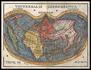
Latina: Universalis Cosmographia |
||||||||||||||||||||||||||||||||||||||||||||||
| Opis |
English: This tiny world map dating from 1546 reflects the extraordinary influence of Martin Waldseemüller's now-famous 1507 cordiform (heart-shaped) wall map of the world Universails Cosmographia Secundum Ptholomaei Traditionem et Americi Vespucii Alioru[m] que Lustrationes… in which Waldseemüller first coined the name "America" for a continent. The little map's creator, Johannes Honter (1498-1549) was born in Kronstadt (today Brasov, Romania) and later worked in Vienna, Regensburg, Krakow, Nuremberg, Basel, and Kronstadt, where with his liberal humanist education he became a respected educator, evangelical pastor, town magistrate, and councilor. While in Regensburg, Bavaria, Honter visited nearby Ingolstadt, where he became friends with humanist, mathematician, astronomer, and cartographer Peter Apian (1495-1552), who in 1520 had created the first copy of Waldseemüller's wall map to appear in a book. The original woodcut for Honter's map was made in Zurich (hence the Latin "Tiguri" seen in the bottom left corner by the initials of the map’s engraver Heinrich Vogtherr the Elder) "at great cost" according to the accompanying text of Rudimenta Cosmographica.... |
||||||||||||||||||||||||||||||||||||||||||||||
| Data | |||||||||||||||||||||||||||||||||||||||||||||||
| Źródło | UTA Libraries Cartographic Connections: mapa / text | ||||||||||||||||||||||||||||||||||||||||||||||
| Twórca |
|
||||||||||||||||||||||||||||||||||||||||||||||
| Sposób pozyskania |
English: The University of Texas at Arlington Libraries Special Collections |
||||||||||||||||||||||||||||||||||||||||||||||
| Georeferencing | If inappropriate please set warp_status = skip to hide. | ||||||||||||||||||||||||||||||||||||||||||||||
| Dane bibliograficzne | |||||||||||||||||||||||||||||||||||||||||||||||
| Publikacja |
Rudimenta Cosmographica |
||||||||||||||||||||||||||||||||||||||||||||||
| Autor |
|
||||||||||||||||||||||||||||||||||||||||||||||
| Miejsce wydania | Zurych | ||||||||||||||||||||||||||||||||||||||||||||||
| Wydawca | |||||||||||||||||||||||||||||||||||||||||||||||
| Dane archiwalne | |||||||||||||||||||||||||||||||||||||||||||||||
| Zbiór |
|
||||||||||||||||||||||||||||||||||||||||||||||
| Rozmiar | wysokość: 12 cm; szerokość: 16,2 cm | ||||||||||||||||||||||||||||||||||||||||||||||
| Medium | ręcznie-kolorowana rycina na papierze | ||||||||||||||||||||||||||||||||||||||||||||||
| artwork-references |
Shirley, Rodney W. (1984) The Mapping of the World: Early Printed World Maps 1472-1700, Londyn: The Holland Press, nr 86 , ss. 97–98 |
||||||||||||||||||||||||||||||||||||||||||||||


Licencja

|
This file was provided to Wikimedia Commons by the University of Texas at Arlington Libraries as part of a cooperation project. The University of Texas at Arlington Libraries is part of the University of Texas at Arlington, a public research university located in Arlington, Texas.
|
|
Autor tej pracy zmarł w 1556 roku, więc ten materiał przeszedł do domeny publicznej w kraju pochodzenia, jak również w państwach i terytoriach, gdzie prawo autorskie wygasa w ciągu 100 lat po śmierci autora. Powyższa praca jest własnością publiczną w Stanach Zjednoczonych, ponieważ została opublikowana (lub zarejestrowana w U.S. Copyright Office) przed 1 stycznia 1929. | |
| Plik rozpoznano jako wolny od znanych ograniczeń praw autorskich, włącznie z prawami zależnymi i pokrewnymi. | |
Historia pliku
Kliknij na datę/czas, aby zobaczyć, jak plik wyglądał w tym czasie.
| Data i czas | Miniatura | Wymiary | Użytkownik | Opis | |
|---|---|---|---|---|---|
| aktualny | 07:28, 21 maj 2019 | | 1200 × 921 (333 KB) | Michael Barera | == {{int:filedesc}} == {{Map |title = ''Universalis Cosmographia'' |description = {{en|This tiny world map dating from 1546 reflects the extraordinary influence of Martin Waldseemüller's now-famous 1507 cordiform (heart-shaped) wall map of the world ''Universails Cosmographia Secundum Ptholomaei Traditionem et Americi Vespucii Alioru[m] que Lustrationes''… in which Waldseemüller first coined the name "America" for a continent. The little map's creator, Johannes Honter (14... |
Lokalne wykorzystanie pliku
Poniższa strona korzysta z tego pliku:
Globalne wykorzystanie pliku
Ten plik jest wykorzystywany także w innych projektach wiki:
- Wykorzystanie na de.wikipedia.org
- Wykorzystanie na en.wikipedia.org
- Wykorzystanie na es.wikipedia.org
- Wykorzystanie na la.wikipedia.org
- Wykorzystanie na pt.wikipedia.org