
Plik:Italy northern 1796.jpg
Rozmiar pierwotny (983 × 932 pikseli, rozmiar pliku: 451 KB, typ MIME: image/jpeg)
| Plik Italy northern 1796.jpg znajduje się w Wikimedia Commons – repozytorium wolnych zasobów. Dane z jego strony opisu znajdują się poniżej. |
Opis
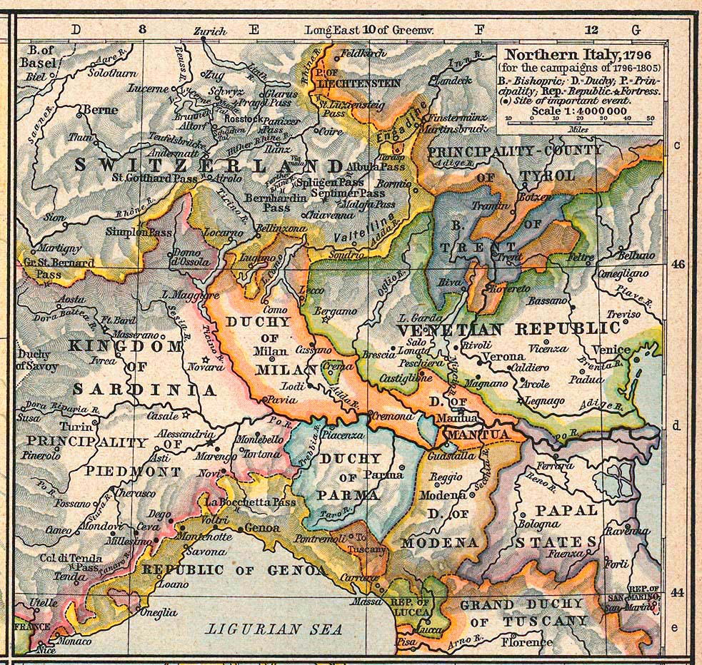
Courtesy of the University of Texas Libraries, The University of Texas at Austin.
| Opis | Northern Italy, 1796 (for the campaigns of 1796-1805) | ||||||||||||||||||||||
| Data | |||||||||||||||||||||||
| Źródło | The Historical Atlas by William R. Shepherd, 1926 | ||||||||||||||||||||||
| Autor |
|
||||||||||||||||||||||
| Licencja (Ponowne użycie tego pliku) |
Copyright expired | ||||||||||||||||||||||
| Inne wersje | http://www.lib.utexas.edu/maps/historical/shepherd/italy_northern_1796.jpg | ||||||||||||||||||||||
Licencja
|
Ten materiał przeszedł do domeny publicznej w kraju pochodzenia, jak również w państwach i terytoriach, gdzie prawo autorskie wygasa w ciągu 70 lat po śmierci autora.
| |
| Plik rozpoznano jako wolny od znanych ograniczeń praw autorskich, włącznie z prawami zależnymi i pokrewnymi. | |
Historia pliku
Kliknij na datę/czas, aby zobaczyć, jak plik wyglądał w tym czasie.
| Data i czas | Miniatura | Wymiary | Użytkownik | Opis | |
|---|---|---|---|---|---|
| aktualny | 17:34, 13 sty 2017 | | 983 × 932 (451 KB) | Afnecors | colour improvement |
| 07:35, 8 kwi 2006 |  | 983 × 932 (389 KB) | Cave cattum | '''Courtesy of the University of Texas Libraries, The University of Texas at Austin.''' {{Information| |Description = Northern Italy, 1796 (for the campaigns of 1796-1805) |Source = The Historical Atlas by William R. Shepherd, 1926 |Date = 1926 |Author = |
Lokalne wykorzystanie pliku
Następujące strony korzystają z tego pliku:
Globalne wykorzystanie pliku
Ten plik jest wykorzystywany także w innych projektach wiki:
- Wykorzystanie na ar.wikipedia.org
- Wykorzystanie na ast.wikipedia.org
- Wykorzystanie na azb.wikipedia.org
- Wykorzystanie na be.wikipedia.org
- Wykorzystanie na bg.wikipedia.org
- Wykorzystanie na br.wikipedia.org
- Wykorzystanie na ca.wikipedia.org
- Wykorzystanie na cs.wikipedia.org
- Wykorzystanie na da.wikipedia.org
- Wykorzystanie na de.wikipedia.org
- Wykorzystanie na el.wikipedia.org
- Wykorzystanie na eml.wikipedia.org
- Wykorzystanie na en.wikipedia.org
Pokaż listę globalnego wykorzystania tego pliku.