
Plik:Kabardino-balkaria map.png
Grafika w wyższej rozdzielczości nie jest dostępna.
Kabardino-balkaria_map.png (450 × 329 pikseli, rozmiar pliku: 33 KB, typ MIME: image/png)
| Plik Kabardino-balkaria map.png znajduje się w Wikimedia Commons – repozytorium wolnych zasobów. Dane z jego strony opisu znajdują się poniżej. |
| Opis |
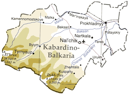
Map of en:Kabardino-Balkaria, en:Russia en:Category:Caucasus maps en:Category:Maps of the Russian republics |
|||
| Źródło | Adapted from "The Caucasus Region" map, US Dept of State [1] | |||
| Autor | User ChrisO on en.wikipedia (uploaded to commons by User:StYxXx) | |||
| Licencja (Ponowne użycie tego pliku) |
|
|||
| Inne wersje |
Prace pochodne od tego pliku: Originally from en.wikipedia; description page is (was) here {{Information |Description=The cooling towers of [[Stella power station]]. |Source=Scanned black and white print |Date=1990 |Author=Aidan Doyle }}{{Information |Description=The cooling towers of [[Stella power station]]. |Source=Scanned black and white print |Date=1990 |Author=Aidan Doyle }}••••••••••••••• |

![[1]](http://www.lib.utexas.edu/maps/commonwealth/caucasus_region_1994.jpg)
(Uploaded using CommonsHelper or PushForCommons)
Historia pliku
Kliknij na datę/czas, aby zobaczyć, jak plik wyglądał w tym czasie.
| Data i czas | Miniatura | Wymiary | Użytkownik | Opis | |
|---|---|---|---|---|---|
| aktualny | 21:45, 12 lis 2006 | | 450 × 329 (33 KB) | StYxXx | {{Information| |Description= Map of en:Kabardino-Balkaria, en:Russia Adapted from "The Caucasus Region" map, US Dept of State [http://www.lib.utexas.edu/maps/commonwealth/caucasus_region_1994.jpg] en:Category:Caucasus maps [[:en:Category: |
Lokalne wykorzystanie pliku
Następujące strony korzystają z tego pliku:
Globalne wykorzystanie pliku
Ten plik jest wykorzystywany także w innych projektach wiki:
- Wykorzystanie na ar.wikipedia.org
- Wykorzystanie na ast.wikipedia.org
- Wykorzystanie na ceb.wikipedia.org
- Wykorzystanie na cy.wikipedia.org
- Wykorzystanie na da.wikipedia.org
- Wykorzystanie na de.wikipedia.org
- Wykorzystanie na el.wikipedia.org
- Wykorzystanie na en.wikipedia.org
- Wykorzystanie na eo.wikipedia.org
- Wykorzystanie na es.wikipedia.org
- Wykorzystanie na eu.wikipedia.org
- Wykorzystanie na fa.wikipedia.org
- Wykorzystanie na fi.wikipedia.org
- Wykorzystanie na fr.wikipedia.org
- Wykorzystanie na gag.wikipedia.org
- Wykorzystanie na hu.wikipedia.org
- Wykorzystanie na ko.wikipedia.org
- Wykorzystanie na nl.wikipedia.org
- Wykorzystanie na nn.wikipedia.org
- Wykorzystanie na sah.wikipedia.org
- Wykorzystanie na sr.wikipedia.org
- Wykorzystanie na tr.wikipedia.org
- Wykorzystanie na uk.wikipedia.org
- Wykorzystanie na www.wikidata.org