
Plik:NIT Combined Flights Ground Measurements 30Mar 03Apr2011 results.jpg

Rozmiar podglądu – 800 × 555 pikseli. Inne rozdzielczości: 320 × 222 pikseli | 640 × 444 pikseli | 1024 × 710 pikseli | 1245 × 863 pikseli.
Rozmiar pierwotny (1245 × 863 pikseli, rozmiar pliku: 612 KB, typ MIME: image/jpeg)
| Plik NIT Combined Flights Ground Measurements 30Mar 03Apr2011 results.jpg znajduje się w Wikimedia Commons – repozytorium wolnych zasobów. Dane z jego strony opisu znajdują się poniżej. |
Opis
| Opis |
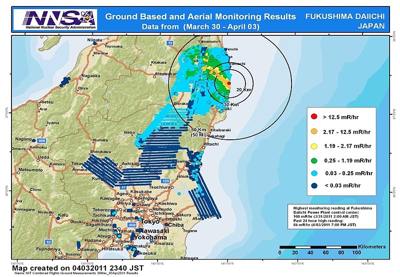
English: Combined results of 211 flight hours of aerial monitoring operations and ground measurements made by DOE, DoD and Japanese monitoring teams. |
| Data | |
| Źródło | 4th slide of http://energy.gov/news/documents/AMS_Data_April_4__v1.pptx available at http://blog.energy.gov/content/situation-japan |
| Autor | National Nuclear Security Administration (NNSA) US Department of Energy |
| Inne wersje |
|


Licencja
| This image is a work of a United States Department of Energy (or predecessor organization) employee, taken or made as part of that person's official duties. As a work of the U.S. federal government, the image is in the public domain.
Please note that national laboratories operate under varying licences and some are not free. Check the site policies of any national lab before crediting it with this tag.
|

|
Historia pliku
Kliknij na datę/czas, aby zobaczyć, jak plik wyglądał w tym czasie.
| Data i czas | Miniatura | Wymiary | Użytkownik | Opis | |
|---|---|---|---|---|---|
| aktualny | 11:36, 9 kwi 2011 | | 1245 × 863 (612 KB) | Teofilo | cropped |
| 11:26, 9 kwi 2011 |  | 1920 × 1080 (689 KB) | Teofilo | {{Information |Description ={{en|1=Combined results of 211 flight hours of aerial monitoring operations and ground measurements made by DOE, DoD and Japanese monitoring teams.}} |Source =4th slide of http://energy.gov/news/documents/AMS_Data_Ap |
Lokalne wykorzystanie pliku
Poniższa strona korzysta z tego pliku:
Globalne wykorzystanie pliku
Ten plik jest wykorzystywany także w innych projektach wiki:
- Wykorzystanie na bg.wikipedia.org
- Wykorzystanie na de.wikipedia.org
- Wykorzystanie na en.wikipedia.org
- Wykorzystanie na en.wikibooks.org
- Wykorzystanie na es.wikipedia.org
- Wykorzystanie na it.wikipedia.org
- Wykorzystanie na ja.wikipedia.org
- Wykorzystanie na pt.wikipedia.org
- Wykorzystanie na so.wikipedia.org
- Wykorzystanie na sr.wikinews.org
- Wykorzystanie na th.wikipedia.org
- Wykorzystanie na www.wikidata.org
- Wykorzystanie na zh.wikipedia.org