
Plik:North West England counties 2023 map.svg

Wielkość pliku podglądu PNG dla pliku SVG: 300 × 599 pikseli Inne rozdzielczości: 120 × 240 pikseli | 240 × 480 pikseli | 385 × 768 pikseli | 513 × 1024 pikseli | 1026 × 2048 pikseli | 674 × 1345 pikseli.
Rozmiar pierwotny (Plik SVG, nominalnie 674 × 1345 pikseli, rozmiar pliku: 1,38 MB)
| Plik North West England counties 2023 map.svg znajduje się w Wikimedia Commons – repozytorium wolnych zasobów. Dane z jego strony opisu znajdują się poniżej. |
Opis
| Opis |
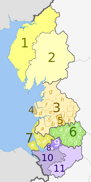
English: Map of the North West region of England, showing its counties and administrative districts since 1 April 2023. The county colours are the same as those in File:English metropolitan and non-metropolitan counties 2009.svg.
Equirectangular map projection on WGS 84 datum, with N/S stretched 160% Geographic limits:
|
| Data | |
| Źródło |
Ten plik jest pochodną pracą: North West England counties 2009 map.svg:  |
| Autor |
Key
| Strategic authority |
Ceremonial county |
Metropolitan or non-metropolitan county |
Metropolitan or non-metropolitan districts May also hold borough and/or city status |
|---|---|---|---|
| Cumbria | 1. Cumberland U.A. | ||
| 2. Westmorland and Furness U.A | |||
| Lancashire | 3. Lancashire † | a) West Lancashire, b) Chorley, c) South Ribble, d) Fylde, e) Preston, f) Wyre, g) Lancaster, h) Ribble Valley, i) Pendle, j) Burnley, k) Rossendale, l) Hyndburn | |
| 4. Blackpool U.A. | |||
| 5. Blackburn with Darwen U.A. | |||
| Greater Manchester | 6. Greater Manchester * | a) Bolton, b) Bury, c) Manchester, d) Oldham, e) Rochdale, f) Salford, g) Stockport, h) Tameside, i) Trafford, j) Wigan | |
| Liverpool City Region | 7. Merseyside * | a) Knowsley, b) Liverpool, c) St. Helens, d) Sefton, e) Wirral | |
| Cheshire | 8. Halton U.A. | ||
| 9. Warrington U.A. | |||
| 10. Cheshire West and Chester U.A. | |||
| 11. Cheshire East U.A. | |||
† Two-tier non-metropolitan county |
|||
U.A. Unitary authority area (non-metropolitan county and district)
| |||
| (no county council) | |||
Licencja
Ten plik udostępniony jest na licencji Creative Commons Uznanie autorstwa – Na tych samych warunkach 3.0.
Uznanie autorstwa: Dr Greg and Nilfanion. Contains Ordnance Survey data © Crown copyright and database right 2010
- Wolno:
- dzielić się – kopiować, rozpowszechniać, odtwarzać i wykonywać utwór
- modyfikować – tworzyć utwory zależne
- Na następujących warunkach:
- uznanie autorstwa – musisz określić autorstwo utworu, podać link do licencji, a także wskazać czy utwór został zmieniony. Możesz to zrobić w każdy rozsądny sposób, o ile nie będzie to sugerować, że licencjodawca popiera Ciebie lub Twoje użycie utworu.
- na tych samych warunkach – Jeśli zmienia się lub przekształca niniejszy utwór, lub tworzy inny na jego podstawie, można rozpowszechniać powstały w ten sposób nowy utwór tylko na podstawie tej samej lub podobnej licencji.
Historia pliku
Kliknij na datę/czas, aby zobaczyć, jak plik wyglądał w tym czasie.
| Data i czas | Miniatura | Wymiary | Użytkownik | Opis | |
|---|---|---|---|---|---|
| aktualny | 22:32, 28 maj 2023 | | 674 × 1345 (1,38 MB) | Dr Greg | Uploaded a work by * ''North West England counties 2009 map.svg'': Dr Greg and Nilfanion, contains Ordnance Survey data * derivative work: Dr Greg from {{Derived from|North West England counties 2009 map.svg|display=50}} with UploadWizard |
Lokalne wykorzystanie pliku
Poniższa strona korzysta z tego pliku:
Globalne wykorzystanie pliku
Ten plik jest wykorzystywany także w innych projektach wiki:
- Wykorzystanie na de.wikipedia.org
- Wykorzystanie na en.wikipedia.org
- Wykorzystanie na fr.wikipedia.org
- Wykorzystanie na zh.wikipedia.org