Plik:Roemer Topographisch-Geognostiche Karte von Texas 1849 UTA.jpg

Treść strony nie jest dostępna w innych językach.
Ten plik jest umieszczony w Wikimedia Commons
Z Wikipedii, wolnej encyklopedii

Rozmiar pierwotny(5826 × 6764 pikseli, rozmiar pliku: 11,85 MB, typ MIME: image/jpeg)

Opis

Tytuł
Deutsch: Topographisch-Geognostische Karte von Texas
Opis
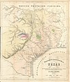
English: Dr. Ferdinand von Roemer's 1849 map of Texas contains considerable information about trails and roads in Texas in addition to other topographical, geological, and even botanical details. It is based upon A New & Correct Map of Texas by James T. D. Wilson, published by R. W. Fishbourne in New Orleans in 1845, a map based upon Texas General Land Office surveys that is quite rare today. Among the routes, trails, and roads depicted by Roemer's map, but also on Wilson's, are: the route of the Texan expedition to Santa Fe in the year 1841; the Chihuahua Trail; the road between Presidio and Nacogdoches; a number of roads in eastern, central, and south Texas; roads in western Louisiana and Arkansas; and even Preston road through Dallas and Bonham to the Red River. Interestingly, the roads labeled as ferries on the eastern side of Wilson's map ("Gaines' Ferry", "Junker's Ferry", "Ballou's Ferry") Von Roemer translates more properly into German as "Fähre" (or literally "trails").


Von Roemer (1818-1891), generally recognized today as the father of Texas geology, was a professor of paleontology from a prominent family in Hildesheim (at that time part of the Kingdom of Hanover) who came to Texas in late 1845 at the request of Baron Ottfried Hans von Meusebach, the Commissioner-General in Texas of the Adelsverein (a German Society of Nobles supporting German emigration to Texas). Von Roemer had the recommendations and financial support of members of the Berlin Academy of Sciences, including Baron Alexander von Humboldt and the great geologist and paleontologist Leopold von Buch. Von Roemer's task in Texas was to make a careful survey of the state, particularly focusing upon areas included in the Adelsverein grant. According to most scholars, he not only accomplished this in the eighteen months he spent here, but also his effort made significant contributions to geology, paleontology, and natural history.
Data
Źródło UTA Libraries Cartographic Connections: mapa / text
Twórca
Ferdinand Roemer  (1818–1891)  wikidata:Q70854 s:en:Author:Carl Ferdinand von Roemer
 
Ferdinand Roemer
Inne nazwiska i pseudonimy
Carl Ferdinand von Roemer
Opis niemiecki botanik, paleontolog, nauczyciel akademicki i geolog
Data urodzenia/śmierci 5 stycznia 1818 Edytuj to na Wikidanych 14 grudnia 1891 / 14 listopada 1891 Edytuj to na Wikidanych
Miejsce urodzenia/śmierci Hildesheim Wrocław
Miejsce działalności
Wykaz autorytatywny
creator QS:P170,Q70854
Henry & Cohen, Bonn
Sposób pozyskania
English: UTA Libraries Special Collections
 Dane geotemporalne
Map location Teksas
Georeferencing Georeference the map in Wikimaps Warper If inappropriate please set warp_status = skip to hide.
 Dane bibliograficzne
Publikacja
Texas. Mit Besonderer Rücksicht auf Deutsche Auswanderung und die Physischen Verhältnisse des Landes
Autor
Ferdinand Roemer  (1818–1891)  wikidata:Q70854 s:en:Author:Carl Ferdinand von Roemer
 
Ferdinand Roemer
Inne nazwiska i pseudonimy
Carl Ferdinand von Roemer
Opis niemiecki botanik, paleontolog, nauczyciel akademicki i geolog
Data urodzenia/śmierci 5 stycznia 1818 Edytuj to na Wikidanych 14 grudnia 1891 / 14 listopada 1891 Edytuj to na Wikidanych
Miejsce urodzenia/śmierci Hildesheim Wrocław
Miejsce działalności
Wykaz autorytatywny
creator QS:P170,Q70854
Miejsce wydania Bonn
Wydawca
Adolph Marcus
 Dane archiwalne
institution QS:P195,Q1230739
Rozmiar wysokość: 56,5 cm; szerokość: 48,5 cm
dimensions QS:P2048,56.5U174728
dimensions QS:P2049,48.5U174728
Medium colored litografia na papierze
artwork-references

Martin i Martin Maps of Texas and the Southwest, 1513-1900, nr 35 , ss. 132−133

Geiser, Samuel Wood (1948) Naturalists of the Frontier, Dallas: SMU Press, ss. 148−171


Licencja

Public domain

Autor tej pracy zmarł w 1891 roku, więc ten materiał przeszedł do domeny publicznej w kraju pochodzenia, jak również w państwach i terytoriach, gdzie prawo autorskie wygasa w ciągu 100 lat po śmierci autora.


Powyższa praca jest własnością publiczną w Stanach Zjednoczonych, ponieważ została opublikowana (lub zarejestrowana w U.S. Copyright Office) przed 1 stycznia 1929.

Podpisy

Dodaj jednolinijkowe objaśnienie tego, co ten plik pokazuje

Obiekty przedstawione na tym zdjęciu

przedstawia

image/jpeg

Historia pliku

Kliknij na datę/czas, aby zobaczyć, jak plik wyglądał w tym czasie.

Data i czasMiniaturaWymiaryUżytkownikOpis
aktualny19:52, 12 mar 2022Miniatura wersji z 19:52, 12 mar 20225826 × 6764 (11,85 MB)Michael Barera== {{int:filedesc}} == {{Map |title = {{de|'''''Topographisch-Geognostische Karte von Texas'''''}} |description = {{en|Dr. Ferdinand von Roemer's 1849 map of Texas contains considerable information about trails and roads in Texas in addition to other topographical, geological, and even botanical details. It is based upon ''A New & Correct Map of Texas'' by James T. D. Wilson, published by R. W. Fishbourne in New Orleans in 1845, a map based upon Texas General Land Office s...

Poniższa strona korzysta z tego pliku:

Globalne wykorzystanie pliku

Ten plik jest wykorzystywany także w innych projektach wiki:

Metadane