
Plik:Uaxactun, Palace A-18 (15958078792).jpg

Rozmiar pierwotny (5184 × 3456 pikseli, rozmiar pliku: 12,59 MB, typ MIME: image/jpeg)
| Plik Uaxactun, Palace A-18 (15958078792).jpg znajduje się w Wikimedia Commons – repozytorium wolnych zasobów. Dane z jego strony opisu znajdują się poniżej. |
.jpg)
Opis
| Opis |
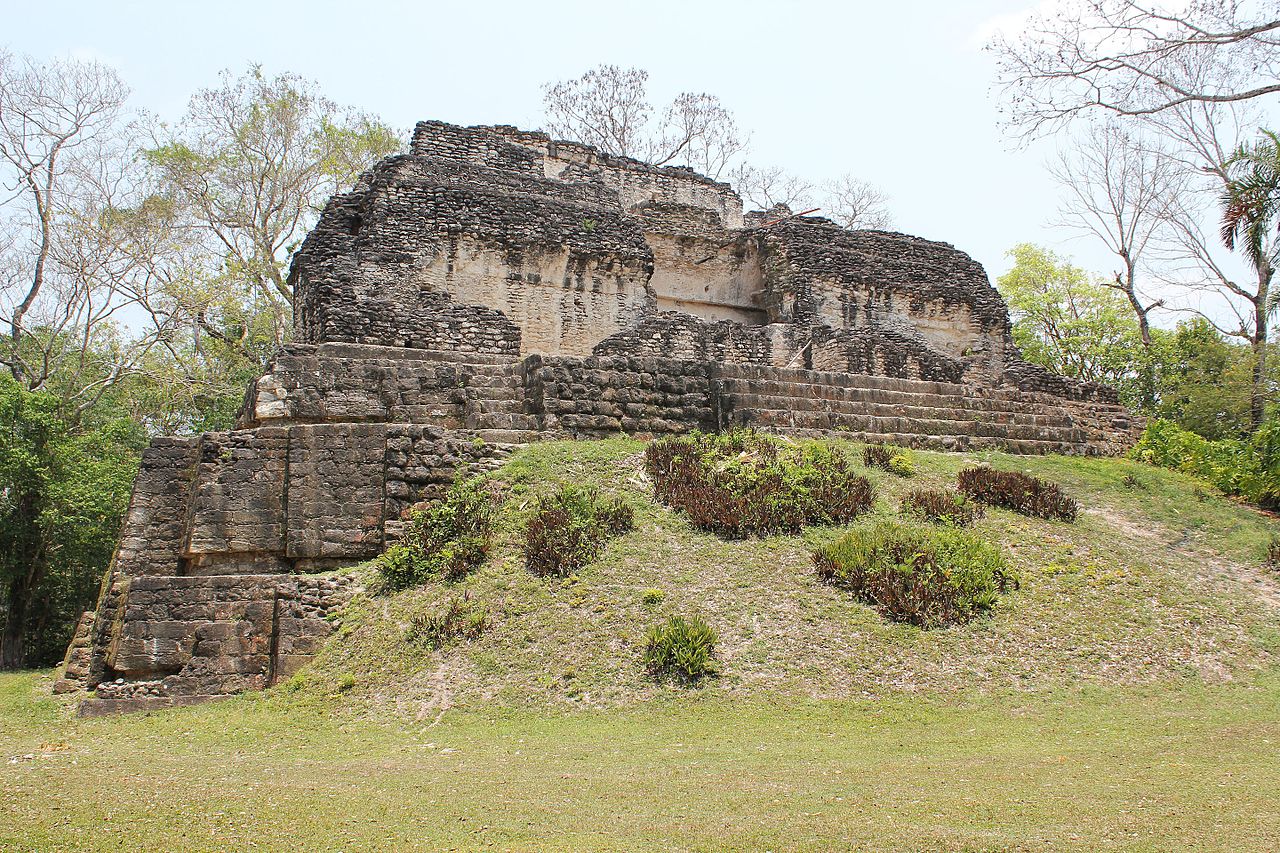
Uaxactun, Palace A-18 Uaxactun is an ancient sacred place of the Maya civilization, located in the Petén Basin region of the Maya lowlands, in the present-day department of Petén, Guatemala. The site lies some 19 km north of the major center of Tikal. A number of ceremonial buildings were erected before the end of the Late Pre Classic Period and the beginning of the Classic. Structure A-XVIII is located in the north-east corner of the acropolis and faces south on the East Plaza. The building, one of the highest at Uaxactun, rests on a steep, rectangular platform-mound which rises in two narrow terraces with nearly vertical sides. It has two stories, the upper one reached by an interior stairway. The lower story consists of three parallel galleries running east and west, of which the front, or southernmost, has largely fallen. The middle gallery is intact except for the doorway and the vault directly above it; the northern gallery is complete. At either end of these galleries are small rooms, several of which have a north-south axis. Entrance to the lower rooms was gained by three doorways on the south and one on the east. The upper story consisted of two galleries over the two northernmost lower galleries. Over the southern lower gallery was a broad terrace. This, as well as all the construction above the spring of the arch of the upper rooms, has fallen. With the exception of the terrace, the upper story conformed almost exactly in plan to the lower. Between the medial molding and the cornice the façade was decorated with large stucco masks. Parts of only seven masks remain, but there is little doubt that originally there were fourteen, five on the north and south sides and two at either end. (source: en.wikipedia.org/wiki/Uaxactun, www.mesoweb.com/publications/CAA_20/CAA_No20.pdf) |
| Data | |
| Źródło | Uaxactun, Palace A-18 |
| Autor | Arian Zwegers from Brussels, Belgium |
| Pozycja fotografa | | To i inne zdjęcia na: OpenStreetMap |
|---|
.jpg¶ms=017.395236_N_-089.637929_E_globe:Earth_type:camera_source:Flickr_&language=pl)
Licencja
- Wolno:
- dzielić się – kopiować, rozpowszechniać, odtwarzać i wykonywać utwór
- modyfikować – tworzyć utwory zależne
- Na następujących warunkach:
- uznanie autorstwa – musisz określić autorstwo utworu, podać link do licencji, a także wskazać czy utwór został zmieniony. Możesz to zrobić w każdy rozsądny sposób, o ile nie będzie to sugerować, że licencjodawca popiera Ciebie lub Twoje użycie utworu.
| Ten plik, opublikowany pierwotnie w serwisie Flickr przez Arian Zwegers pod adresem https://flickr.com/photos/67769030@N07/15958078792, został sprawdzony 29 maja 2016 przez FlickreviewR, który potwierdził, że jest on tam dostępny na licencji cc-by-2.0. |
Historia pliku
Kliknij na datę/czas, aby zobaczyć, jak plik wyglądał w tym czasie.
| Data i czas | Miniatura | Wymiary | Użytkownik | Opis | |
|---|---|---|---|---|---|
| aktualny | 20:39, 29 maj 2016 | | 5184 × 3456 (12,59 MB) | Moheen | {{Information |Description=Uaxactun, Palace A-18 Uaxactun is an ancient sacred place of the Maya civilization, located in the Petén Basin region of the Maya lowlands, in the present-day department of Petén, Guatemala. The site lies some 19 km north... |
Lokalne wykorzystanie pliku
Poniższa strona korzysta z tego pliku:
.jpg)