
Plik:Vinland-map greenland.jpg
Grafika w wyższej rozdzielczości nie jest dostępna.
Vinland-map_greenland.jpg (288 × 276 pikseli, rozmiar pliku: 38 KB, typ MIME: image/jpeg)
| Plik Vinland-map greenland.jpg znajduje się w Wikimedia Commons – repozytorium wolnych zasobów. Dane z jego strony opisu znajdują się poniżej. |
Opis
| Opis |
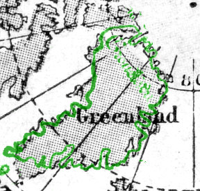
English: Monochrome enlargement of small-scale map of Greenland |
| Data | 29 października 2007 (data pierwszego przesłania pliku) |
| Źródło | From "Harmsworth's Atlas of the World" (Amalgamated Press, 1922; now out-of-copyright) overlaid by this contributor, David Trochos, in green at the same scale and angle, with the representation of Greenland from the Vinland Map scan at File:Vinland_Map_HiRes.jpg. |
| Autor | David Trochos at en.wikipedia |
Licencja
| Ten utwór został udostępniony jako własność publiczna przez jego autora, David Trochos z angielskiej Wikipedii. Dotyczy to całego świata. W niektórych krajach może nie być to prawnie możliwe, jeśli tak, to: David Trochos zapewnia każdemu prawo do użycia tej pracy w dowolnym celu, bez żadnych ograniczeń, chyba że te ograniczenia są wymagane przez prawo. |
Oryginalny rejestr przesyłania
Oryginalna strona opisu była tutaj. Wszystkie poniższe nazwy użytkowników odwołują się do en.wikipedia.
Upload date | User | Bytes | Dimensions | Comment
- 2007-11-09 19:13 (UTC) | David Trochos | 39342 (bytes) | 288×276 | Monochrome enlargement of small-scale map of Greenland from "Harmsworth's Atlas of the World" (Amalgamated Press, 1922; now out-of-copyright) overlaid by this contributor, David Trochos, in green at the same scale and angle, with the representation of Gre
- 2007-10-29 20:04 (UTC) | David Trochos | 33802 (bytes) | 288×276 | Monochrome enlargement of small-scale map of Greenland from "Harmsworth's Atlas of the World" (Amalgamated Press, 1922; now out-of-copyright) overlaid by this contributor, David Trochos, in green at the same scale and angle, with the representation of Gre
Historia pliku
Kliknij na datę/czas, aby zobaczyć, jak plik wyglądał w tym czasie.
| Data i czas | Miniatura | Wymiary | Użytkownik | Opis | |
|---|---|---|---|---|---|
| aktualny | 11:36, 11 paź 2011 | | 288 × 276 (38 KB) | SreeBot | (Original text) : Monochrome enlargement of small-scale map of Greenland from "Harmsworth's Atlas of the World" (Amalgamated Press, 1922; now out-of-copyright) overlaid by this contributor, David Trochos, in green at the same scale and angle, with the rep |
| 11:36, 11 paź 2011 |  | 288 × 276 (33 KB) | SreeBot | (Original text) : Monochrome enlargement of small-scale map of Greenland from "Harmsworth's Atlas of the World" (Amalgamated Press, 1922; now out-of-copyright) overlaid by this contributor, David Trochos, in green at the same scale and angle, with the rep |
Lokalne wykorzystanie pliku
Poniższa strona korzysta z tego pliku:
Globalne wykorzystanie pliku
Ten plik jest wykorzystywany także w innych projektach wiki:
- Wykorzystanie na en.wikipedia.org
- Wykorzystanie na ja.wikipedia.org
- Wykorzystanie na ru.wikipedia.org