
Plik:Western Empire-Europe870.JPG
Western_Empire-Europe870.JPG (428 × 317 pikseli, rozmiar pliku: 83 KB, typ MIME: image/jpeg)
| Plik Western Empire-Europe870.JPG znajduje się w Wikimedia Commons – repozytorium wolnych zasobów. Dane z jego strony opisu znajdują się poniżej. |
Opis
| Opis |
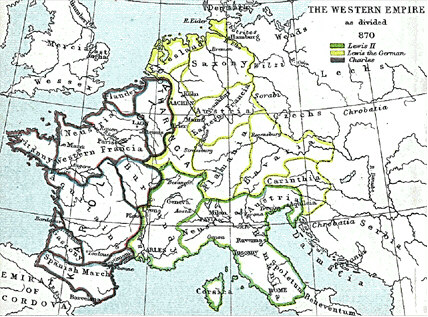
English: Frank king Charlemagne's kingdom survived the leader and covered much of Western Europe from 795 until 843 when a treaty split it amongst his grandsons: Central Franks ruled by w:Lothar I (green), East Franks ruled by w:Louis the German (yellow), and w:Charles the Bald led West Franks (purple). This particular map is from the Atlas to Freeman's Historical Geography, edited by J.B. Bury, Longmans Green and Co. Third Edition 1903. It is in the public domain and you may download it or print it for any use. |
| Data | |
| Źródło | Atlas To Freeman's Historical Geography |
| Autor | J.B. Bury |
Na Commons przeniósł z en.wikipedia użytkownik Maksim.
Oryginalny rejestr przesyłania ====
|
Ten materiał przeszedł do domeny publicznej w kraju pochodzenia, jak również w państwach i terytoriach, gdzie prawo autorskie wygasa w ciągu 70 lat po śmierci autora.
| |
| Plik rozpoznano jako wolny od znanych ograniczeń praw autorskich, włącznie z prawami zależnymi i pokrewnymi. | |
Historia pliku
Kliknij na datę/czas, aby zobaczyć, jak plik wyglądał w tym czasie.
| Data i czas | Miniatura | Wymiary | Użytkownik | Opis | |
|---|---|---|---|---|---|
| aktualny | 16:21, 22 sty 2006 | | 428 × 317 (83 KB) | Maksim | La bildo estas kopiita de wikipedia:en. La originala priskribo estas: Frank king Charlemagne's kingdom survived the leader and covered much of Western Europe from 795 until 843 when a treaty split it amongst his grandsons: Cen |
Lokalne wykorzystanie pliku
Poniższa strona korzysta z tego pliku:
Globalne wykorzystanie pliku
Ten plik jest wykorzystywany także w innych projektach wiki:
- Wykorzystanie na ar.wikipedia.org
- Wykorzystanie na ca.wikipedia.org
- Wykorzystanie na cs.wikipedia.org
- Wykorzystanie na da.wikipedia.org
- Wykorzystanie na de.wikipedia.org
- Wykorzystanie na en.wikipedia.org
- Wykorzystanie na eo.wikipedia.org
- Wykorzystanie na es.wikipedia.org
- Wykorzystanie na et.wikipedia.org
- Wykorzystanie na gl.wikipedia.org
- Wykorzystanie na it.wikipedia.org
- Wykorzystanie na ja.wikipedia.org
- Wykorzystanie na la.wikipedia.org
- Wykorzystanie na no.wikipedia.org
- Wykorzystanie na sh.wikipedia.org
- Wykorzystanie na simple.wikipedia.org