
Chhusang
Na mapach:  28°59′N 83°49′E/28,983333 83,816667
| gaun wikas samiti | |

| |
| Państwo | |
|---|---|
| Strefa | |
| Dystrykt | |
| Populacja (2001) • liczba ludności |
|
Położenie na mapie Nepalu  | |
Chhusang – gaun wikas samiti w zachodniej części Nepalu w strefie Dhawalagiri w dystrykcie Mustang[1]. Według nepalskiego spisu powszechnego z 2001 roku liczył on 186 gospodarstw domowych i 668 mieszkańców (336 kobiet i 332 mężczyzn)[2].
- VDC Chhusang
-
 Chhusang
 -
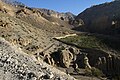
 Droga Chhusang - Chele
 -
 Chele
Chele -
 Droga Chele - Samar
 -
 Samar
Samar -
 Ghyakar
 -
 Thangbe


Przypisy[edytuj | edytuj kod]
- ↑ Index of Geographical names of Nepal - Western Development Region - Volume III. National Geographic Information Infrastructure Programme. [dostęp 2010-09-27]. (ang.).
- ↑ VDC’s population. National Association of Village Development Committees in Nepal (NAVIN). [dostęp 2020-10-12]. (ang.).