
Plik:2008 09L 5-day track.gif
Rozmiar pierwotny (895 × 716 pikseli, rozmiar pliku: 37 KB, typ MIME: image/gif)
| Plik 2008 09L 5-day track.gif znajduje się w Wikimedia Commons – repozytorium wolnych zasobów. Dane z jego strony opisu znajdują się poniżej. |
Opis
| Opis |
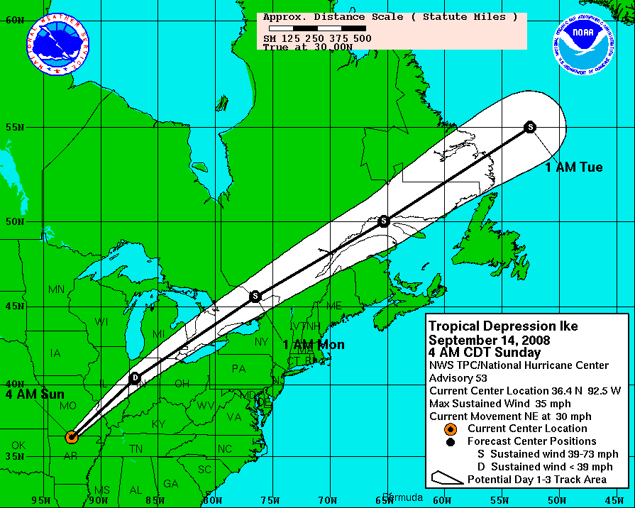
Hurricane Ike 5-day tracking map from NHC. The mileage ruler is in statute miles, where 5 degrees of latitude span 345.2 miles (555.8 km),[1][2] and 5 degrees of longitude at 30 degrees North latitude span 299.8 miles (482.7 km).[3] The scale and offset of the map can vary with each advisory (compare map boundaries of advisories 43 & 44), re-centered for the latest forecast path (white cone). |
| Data | September 13, 2008 - 8AM CDT, Saturday |
| Źródło | http://www.nhc.noaa.gov/graphics_at4.shtml?5day#contents |
| Autor | NHC/NOAA |
Licencja
Ta grafika została utworzona przez pracownika Amerykańskiej Narodowej Służby Oceanicznej i Meteorologicznej podczas wykonywania czynności służbowych. Jako utwór Rządu Federalnego Stanów Zjednoczonych, grafika ta znajduje się w domenie publicznej.
|
Distances for latitude or longitude
Measured in statue miles, 5 degrees of latitude span 345.2 miles (555.8 km), based on 1 degree as 69.05 statute miles (111.2 km), or 60 nautical miles. [1][2]
Longitude varies in length according to degree of latitude.[2] The following are a sampling of longitude lengths for selected latitudes, starting in the southern US and moving north:
- at 30 degrees North (area of Houston, Texas), a degree of longitude is 59.96 statute miles;[2]
- at 35 degrees North (area of Albuquerque, NM), a degree of longitude is 56.73 statute miles;
- at 40 degrees North (Kansas/Nebraska border), a degree of longitude is 53.06 statute miles;
- at 45 degrees North (Montana/Wyoming border), a degree of longitude is 49.00 statute miles.[2]
At 30 degrees North (near Houston), 5 degrees of longitude span 299.8 miles (555.8 km),[3] and at 35 north (near Albuquerque), 5 degrees of longitude span 283.65 (~284 miles, 457 km).[3]
Notes
- ↑ a b "Weights and Measures" (conversion tables), Upper New England Coast (UNEC) Cyber Community, 1999, webpage: UNEC.
- ↑ a b c d e "Latitude-Longitude Conversion to Feet", The Sentinel, February 2001, webpage: HyperNews-SAR-291 archive copy at the Wayback Machine.
- ↑ a b c For 30 degrees North, 5 degrees = 5 * 59.96 = 299.80 miles; for 35 degrees North, 5 degrees = 5 * 56.73 = 283.65 miles; based on the longitude conversion factors (see: References).
References
- "Latitude-Longitude Conversion to Feet", The Sentinel, February 2001, webpage: HyperNews-SAR-291 archive copy at the Wayback Machine.
Historia pliku
Kliknij na datę/czas, aby zobaczyć, jak plik wyglądał w tym czasie.
| Data i czas | Miniatura | Wymiary | Użytkownik | Opis | |
|---|---|---|---|---|---|
| aktualny | 16:14, 14 wrz 2008 | | 895 × 716 (37 KB) | DOSGuy | Advisory 53 |
| 05:04, 14 wrz 2008 |  | 895 × 716 (36 KB) | DOSGuy | Advisory 52 | |
| 17:05, 13 wrz 2008 |  | 895 × 716 (34 KB) | DOSGuy | Advisory 50 | |
| 16:44, 13 wrz 2008 |  | 895 × 716 (32 KB) | Prosfilaes | Advisory 49B | |
| 11:11, 13 wrz 2008 |  | 895 × 716 (33 KB) | TheTallOne~commonswiki | == Summary == {{Information |Description=Hurricane Ike 5-day tracking map from NHC. The mileage ruler is in statute miles, where 5 degrees of latitude span 345.2 miles (555.8 km),<ref name=WMeas/><ref name=LLconv/> and 5 degree | |
| 03:42, 13 wrz 2008 |  | 895 × 716 (28 KB) | Smichae | Advisory 47B | |
| 01:57, 13 wrz 2008 |  | 895 × 716 (28 KB) | Prosfilaes | {{Information |Description= |Source= |Date= |Author= |Permission= |other_versions= }} | |
| 22:14, 12 wrz 2008 |  | 895 × 716 (26 KB) | Smichae | Advisory 46A | |
| 17:29, 12 wrz 2008 |  | 895 × 716 (26 KB) | MarsInSVG | {{Information |Description=Hurricane Ike 5-day tracking map from NHC. The mileage ruler is in statute miles, where 5 degrees of latitude span 345.2 miles (555.8 km),<ref name=WMeas/><ref name=LLconv/> and 5 degrees of longitude | |
| 11:04, 12 wrz 2008 |  | 895 × 716 (34 KB) | Keith Edkins | Advisory 45 |
Lokalne wykorzystanie pliku
Poniższa strona korzysta z tego pliku:
Globalne wykorzystanie pliku
Ten plik jest wykorzystywany także w innych projektach wiki:
- Wykorzystanie na ar.wikipedia.org
- Wykorzystanie na en.wikipedia.org
- Wykorzystanie na nl.wikipedia.org
- Wykorzystanie na sv.wikipedia.org
- Wykorzystanie na ta.wikipedia.org