
Plik:Earth's City Lights by DMSP, 1994-1995 (medium).png
Rozmiar pierwotny (2560 × 1280 pikseli, rozmiar pliku: 2,56 MB, typ MIME: image/png)
| Plik Earth's City Lights by DMSP, 1994-1995 (medium).png znajduje się w Wikimedia Commons – repozytorium wolnych zasobów. Dane z jego strony opisu znajdują się poniżej. |
Opis
| Opis |
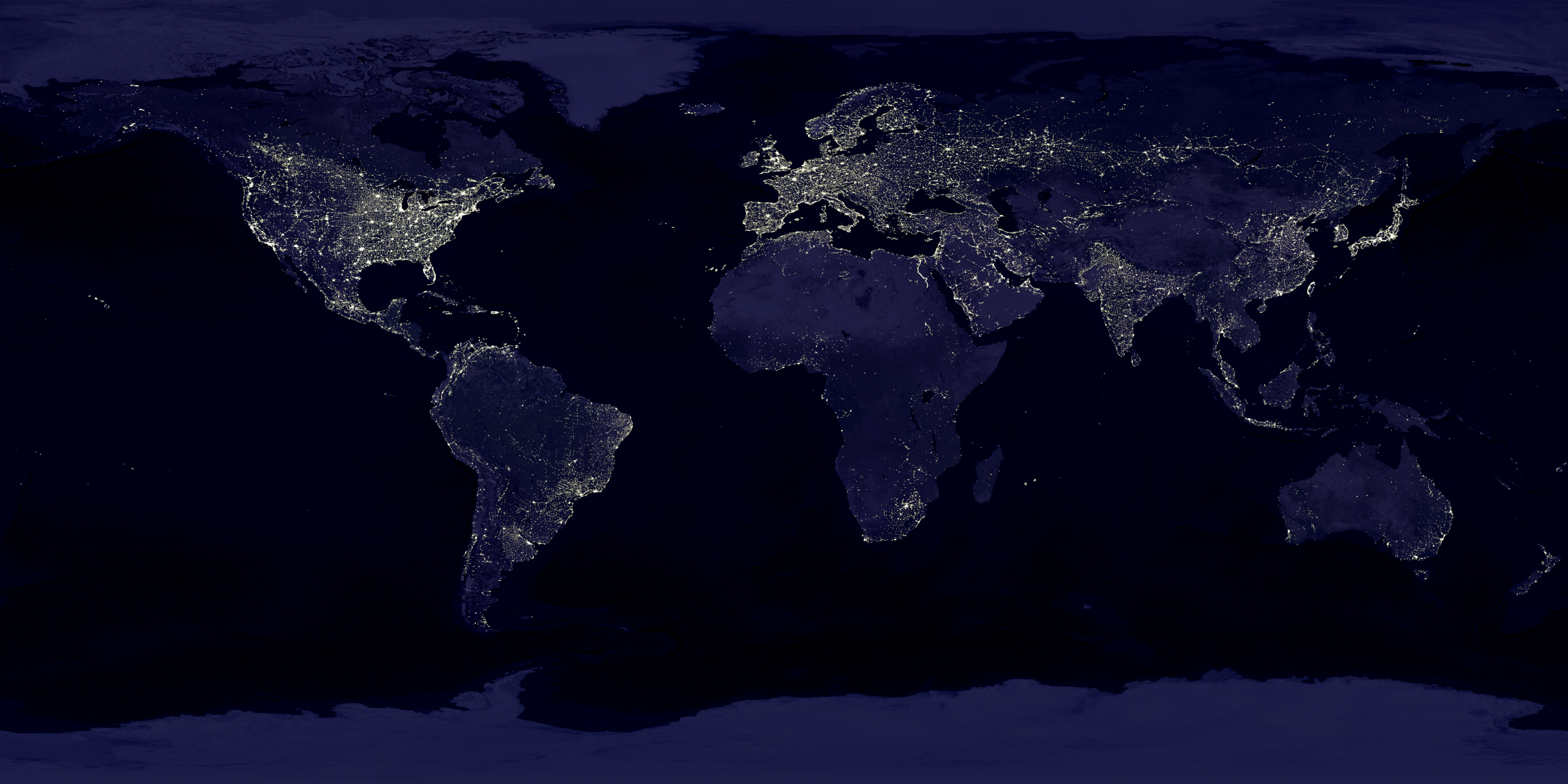
English: This image of Earth’s city lights was created with data from the Defense Meteorological Satellite Program (DMSP) Operational Linescan System (OLS). Originally designed to view clouds by moonlight, the OLS is also used to map the locations of permanent lights on the Earth’s surface.
The brightest areas of the Earth are the most urbanized, but not necessarily the most populated. (Compare western Europe with China and India.) Cities tend to grow along coastlines and transportation networks. Even without the underlying map, the outlines of many continents would still be visible. The United States interstate highway system appears as a lattice connecting the brighter dots of city centers. In Russia, the Trans-Siberian railroad is a thin line stretching from Moscow through the center of Asia to Vladivostok. The Nile River, from the Aswan Dam to the Mediterranean Sea, is another bright thread through an otherwise dark region. Even more than 100 years after the invention of the electric light, some regions remain thinly populated and unlit. Antarctica is entirely dark. The interior jungles of Africa and South America are mostly dark, but lights are beginning to appear there. Deserts in Africa, Arabia, Australia, Mongolia, and the United States are poorly lit as well (except along the coast), along with the boreal forests of Canada and Russia, and the great mountains of the Himalaya. |
| Data | między 1 paźdźernikiem 1994 a 31 marcem 1995 |
| Źródło | https://visibleearth.nasa.gov/view.php?id=55167 (image link) |
| Autor | Data: Marc Imhoff/NASA GSFC, Christopher Elvidge/NOAA NGDC; Image: Craig Mayhew and Robert Simmon/NASA GSFC |
| Inne wersje |
|
.jpg)
.jpg)
.png)

.png)
Licencja
| Ten plik jest w domenie publicznej ponieważ został stworzony przez NASA. Polityka praw autorskich NASA stwierdza, że „materiały NASA nie są chronione prawami autorskimi, chyba że zapisano inaczej”. (NASA copyright policy lub JPL Image Use Policy). | ||
 |
Uwaga:
|
Ta grafika została utworzona przez pracownika Amerykańskiej Narodowej Służby Oceanicznej i Meteorologicznej podczas wykonywania czynności służbowych. Jako utwór Rządu Federalnego Stanów Zjednoczonych, grafika ta znajduje się w domenie publicznej.
|
Historia pliku
Kliknij na datę/czas, aby zobaczyć, jak plik wyglądał w tym czasie.
| Data i czas | Miniatura | Wymiary | Użytkownik | Opis | |
|---|---|---|---|---|---|
| aktualny | 20:49, 15 kwi 2017 | | 2560 × 1280 (2,56 MB) | Huntster | Standardise appearance in series. |
| 22:45, 9 mar 2009 |  | 2560 × 1364 (2,18 MB) | Tryphon | Higher resolution. | |
| 17:05, 18 wrz 2007 |  | 1499 × 797 (658 KB) | Jonathan Kovaciny~commonswiki | Re-cropped version of original NASA image. | |
| 17:03, 18 wrz 2007 |  | 1521 × 797 (667 KB) | Jonathan Kovaciny~commonswiki | Cropped version of the original NASA image. | |
| 18:26, 30 mar 2007 |  | 1500 × 1125 (1,61 MB) | Laur2ro | {{Information |Description=Earth lights, image is slightly edited (increased contrast and brightness; similar to Image:Whole world - at night.png, but the continents are visible also). |Source=http://visibleearth.nasa.gov/view_rec.php?id=11793 |Date=m |
Lokalne wykorzystanie pliku
Poniższa strona korzysta z tego pliku:
Globalne wykorzystanie pliku
Ten plik jest wykorzystywany także w innych projektach wiki:
- Wykorzystanie na ar.wikipedia.org
- Wykorzystanie na ca.wikipedia.org
- Wykorzystanie na en.wikipedia.org
- Wykorzystanie na en.wikiquote.org
- Wykorzystanie na en.wikiversity.org
- Wykorzystanie na es.wikinews.org
- Wykorzystanie na fr.wikipedia.org
- Wykorzystanie na fr.wikiversity.org
- Wykorzystanie na ha.wikipedia.org
- Wykorzystanie na hi.wikipedia.org
- Wykorzystanie na hr.wikipedia.org
- Wykorzystanie na it.wikipedia.org
- Wykorzystanie na mwl.wikipedia.org
- Wykorzystanie na ru.wikipedia.org
- Wykorzystanie na sh.wikipedia.org
- Wykorzystanie na uk.wikipedia.org
- Wykorzystanie na uz.wikipedia.org
- Wykorzystanie na www.wikidata.org
.png)