
Plik:Fleurieu Peninsula, South Australia – satellite map.tif
Wielkość pliku podglądu PNG dla pliku TIF: 605 × 599 pikseli Inne rozdzielczości: 242 × 240 pikseli | 485 × 480 pikseli | 776 × 768 pikseli | 1034 × 1024 pikseli | 1518 × 1503 pikseli.
Rozmiar pierwotny (1518 × 1503 pikseli, rozmiar pliku: 8,71 MB, typ MIME: image/tiff)
| Plik Fleurieu Peninsula, South Australia – satellite map.tif znajduje się w Wikimedia Commons – repozytorium wolnych zasobów. Dane z jego strony opisu znajdują się poniżej. |
Opis
| Opis |
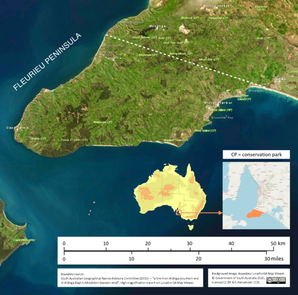
English: A satellite map of Fleurieu Peninsula, South Australia |
| Data | |
| Źródło |
Map: Location SA MapViewer (http://location.sa.gov.au/viewer/) Artwork: own work |
| Autor | Government of South Australia |
| Pozycja fotografa | | To i inne zdjęcia na: OpenStreetMap |
|---|
Licencja
Ten plik udostępniony jest na licencji Creative Commons Uznanie autorstwa 4.0 Międzynarodowe.
Uznanie autorstwa: Government of South Australia.
The Government of South Australia owns copyright in this work, which it has licensed in keeping with the Open Data Policy initiated by the Australian Government. The Policy includes the direction: "all government agencies should make non-sensitive data open by default, and it should be free, easy to use, and reliable. Agencies should publish anonymised data ... under a Creative Commons BY Attribution licence."
The Government of South Australia owns copyright in this work, which it has licensed in keeping with the Open Data Policy initiated by the Australian Government. The Policy includes the direction: "all government agencies should make non-sensitive data open by default, and it should be free, easy to use, and reliable. Agencies should publish anonymised data ... under a Creative Commons BY Attribution licence."
- Wolno:
- dzielić się – kopiować, rozpowszechniać, odtwarzać i wykonywać utwór
- modyfikować – tworzyć utwory zależne
- Na następujących warunkach:
- uznanie autorstwa – musisz określić autorstwo utworu, podać link do licencji, a także wskazać czy utwór został zmieniony. Możesz to zrobić w każdy rozsądny sposób, o ile nie będzie to sugerować, że licencjodawca popiera Ciebie lub Twoje użycie utworu.
Historia pliku
Kliknij na datę/czas, aby zobaczyć, jak plik wyglądał w tym czasie.
| Data i czas | Miniatura | Wymiary | Użytkownik | Opis | |
|---|---|---|---|---|---|
| aktualny | 07:10, 27 sty 2021 |  | 1518 × 1503 (8,71 MB) | SCHolar44 | Uploaded a work by Government of South Australia from Map: Location SA MapViewer (http://location.sa.gov.au/viewer/) Artwork: own work with UploadWizard |
Lokalne wykorzystanie pliku
Poniższa strona korzysta z tego pliku:
Globalne wykorzystanie pliku
Ten plik jest wykorzystywany także w innych projektach wiki:
- Wykorzystanie na en.wikipedia.org
- Wykorzystanie na et.wikipedia.org
- Wykorzystanie na id.wikipedia.org
- Wykorzystanie na tr.wikipedia.org