
Plik:Moravske.slezsko.png

Rozmiar podglądu – 800 × 594 pikseli. Inne rozdzielczości: 320 × 237 pikseli | 640 × 475 pikseli | 1024 × 760 pikseli | 1108 × 822 pikseli.
Rozmiar pierwotny (1108 × 822 pikseli, rozmiar pliku: 172 KB, typ MIME: image/png)
| Plik Moravske.slezsko.png znajduje się w Wikimedia Commons – repozytorium wolnych zasobów. Dane z jego strony opisu znajdują się poniżej. |
Opis
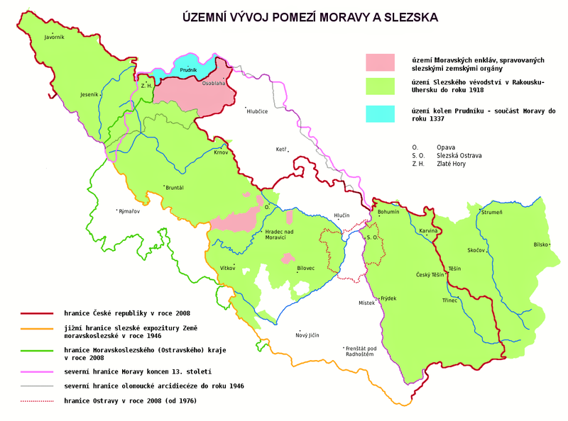
| Opis | Map showing the historical development of border between Moravia and Silesia, borders of the Silesian subdivision (Slezská expozitura) within the Moravian-Silesian Land (Země Moravskoslezská) of Czechoslovakia, borders of the Moravian-Silesian Region of the Czech Republic, borders of the Duchy of Silesia of Austria-Hungary and borders of the City of Ostrava. Red line shows the border of the Czech Republic in 2008. Yellow line shows the southern border of the Silesian subdivision within the Moravian-Silesian Land of Czechoslovakia. Green line shows the border of the Moravian-Silesian Region (Moravskoslezský kraj) of the Czech Republic. Pink line shows the northern border of Moravia at the end of the 13th century. Grey line shows the northern border of the Olomouc Archdiocese. Dotted line shows the border of the City of Ostrava in 2008. The area in green shows the former Duchy of Silesia (the Austrian Silesia). The area in blue shows land around Prudnik, which was a part of Moravia until 1337. The descriptions are in Czech. |
| Data | |
| Źródło | Praca własna |
| Autor | Amic, corrected by Kirk |
| Licencja (Ponowne użycie tego pliku) |
Public Domain |
Licencja
| Ja, właściciel praw autorskich do tej pracy, udostępniam ją jako własność publiczną. Dotyczy to całego świata. W niektórych krajach może nie być to prawnie możliwe, jeśli tak, to: Zapewniam każdemu prawo do użycia tej pracy w dowolnym celu, bez żadnych ograniczeń, chyba że te ograniczenia są wymagane przez prawo. |
Historia pliku
Kliknij na datę/czas, aby zobaczyć, jak plik wyglądał w tym czasie.
| Data i czas | Miniatura | Wymiary | Użytkownik | Opis | |
|---|---|---|---|---|---|
| aktualny | 19:31, 9 maj 2021 | | 1108 × 822 (172 KB) | ElCet | Prudník |
| 14:48, 3 lis 2010 |  | 1108 × 822 (194 KB) | Kostěj | second attempt | |
| 14:45, 3 lis 2010 |  | 1108 × 822 (194 KB) | Kostěj | description correction (the file is used on or comes from the Moravian movement webpages (for example, here: http://zamoravu.eu/mno-k-morave/slezsko/), who consider the Czech Silesia (or at least most of its territory) to be part of Moravia, which is a PO | |
| 14:16, 27 paź 2010 |  | 1108 × 822 (59 KB) | Kirk979 | correction | |
| 18:18, 2 sie 2009 |  | 1108 × 822 (194 KB) | STS Chvojkovice-Brod | přesnější popis | |
| 00:55, 4 lip 2008 |  | 1108 × 822 (59 KB) | Kirk979 | {{Information |Description= |Source= |Date= |Author= |Permission= |other_versions= }} | |
| 00:52, 4 lip 2008 |  | 1108 × 822 (59 KB) | Kirk979 | {{Information |Description= |Source= |Date= |Author= |Permission= |other_versions= }} | |
| 18:02, 3 lip 2008 |  | 1108 × 822 (59 KB) | Kirk979 | {{Information |Description= |Source= |Date= |Author= |Permission= |other_versions= }} | |
| 10:41, 18 maj 2008 |  | 1108 × 822 (56 KB) | Amic~commonswiki | {{Information |Description=The historical development of Moravian (or Czech or also Austrian) Silesia. Description in Czech language. |Source=own work |Date=18.5.2008 |Author=Amic |Permission=Public Domain |other_versions=none }} [[Category:Maps_of_the_Cz |
Lokalne wykorzystanie pliku
Następujące strony korzystają z tego pliku:
Globalne wykorzystanie pliku
Ten plik jest wykorzystywany także w innych projektach wiki:
- Wykorzystanie na cs.wikipedia.org
- Wykorzystanie na sk.wikipedia.org