
Plik:Spitsbergen labelled.png
Grafika w wyższej rozdzielczości nie jest dostępna.
Spitsbergen_labelled.png (451 × 446 pikseli, rozmiar pliku: 161 KB, typ MIME: image/png)
| Plik Spitsbergen labelled.png znajduje się w Wikimedia Commons – repozytorium wolnych zasobów. Dane z jego strony opisu znajdują się poniżej. |
Opis
| Opis |
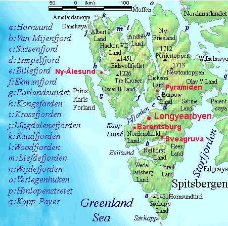
English: Map detailing the marine features of Spitsbergen in the Svalbard archipelago. Settlements and mountains are indicated and labelled. See also Image:Spitsbergen mountains and marine features labelled.png. Locations were labelled mainly based on detailed maps from svalbard-images.com (sample of south Spitsbergen linked), cross-referenced with other map sources where possible. Norwegian Polar Institute figures were used for mountain names and heights, which are given in meters above sea level. |
| Data | 25 lipca 2006 (data pierwszego przesłania pliku) |
| Źródło | Źródło nie zostało podane w rozpoznawalny automatycznie sposób. Założono, że to praca własna (w oparciu o szablon praw autorskich). |
| Autor | Autor nie został podany w rozpoznawalny automatycznie sposób. Założono, że to TheGrappler (w oparciu o szablon praw autorskich). |
Licencja
DEMIS World Map Server archive copy at the Wayback Machine generated this map from Public Domain sources. DEMIS does not claim any rights over the resultant image ([1] archive copy at the Wayback Machine). Alterations, including the addition of settlements and captions, were performed on 24 July 2006 by User:TheGrappler, the uploader, who releases all associated rights.
| Ja, właściciel praw autorskich do tej pracy, udostępniam ją jako własność publiczną. Dotyczy to całego świata. W niektórych krajach może nie być to prawnie możliwe, jeśli tak, to: Zapewniam każdemu prawo do użycia tej pracy w dowolnym celu, bez żadnych ograniczeń, chyba że te ograniczenia są wymagane przez prawo. |
This image is in the public domain because it came from the site https://www.demis.nl/products/web-map-server/examples/ and was released by the copyright holder. Permission is granted to copy, distribute and/or modify this map since it is based on free of copyright images from: www.demis.nl. See also approval email on de.wp and its clarification.
|
| Ten utwór został udostępniony jako własność publiczna przez jego właściciela praw autorskich, www.demis.nl. Dotyczy to całego świata. W niektórych krajach może nie być to prawnie możliwe, jeśli tak, to: www.demis.nl zapewnia każdemu prawo do użycia tej pracy w dowolnym celu, bez żadnych ograniczeń, chyba że te ograniczenia są wymagane przez prawo.
|
Historia pliku
Kliknij na datę/czas, aby zobaczyć, jak plik wyglądał w tym czasie.
| Data i czas | Miniatura | Wymiary | Użytkownik | Opis | |
|---|---|---|---|---|---|
| aktualny | 11:23, 26 lip 2006 | | 451 × 446 (161 KB) | TheGrappler | More detail in South |
| 02:58, 25 lip 2006 |  | 451 × 446 (159 KB) | TheGrappler | Move "Albert I Land" label slightly, to avoid obscuring Magdalenefjorden | |
| 02:46, 25 lip 2006 |  | 451 × 446 (160 KB) | TheGrappler | == Summary == {{English}} Map detailing the marine features of Spitsbergen in the Svalbard archipelago. Settlements and mountains are indicated and labelled. See also Image:Spitsbergen mountains and marine features labelled.png. Locations were labell |
Lokalne wykorzystanie pliku
Poniższa strona korzysta z tego pliku:
Globalne wykorzystanie pliku
Ten plik jest wykorzystywany także w innych projektach wiki:
- Wykorzystanie na af.wikipedia.org
- Wykorzystanie na ast.wikipedia.org
- Wykorzystanie na az.wikipedia.org
- Wykorzystanie na bg.wikipedia.org
- Wykorzystanie na ca.wikipedia.org
- Wykorzystanie na ceb.wikipedia.org
- Wykorzystanie na cv.wikipedia.org
- Wykorzystanie na da.wikipedia.org
- Wykorzystanie na de.wikipedia.org
- Wykorzystanie na el.wikipedia.org
- Wykorzystanie na en.wikipedia.org
- Spitsbergen
- Danes Island
- Isfjorden (Svalbard)
- Wijdefjorden
- Van Mijenfjorden
- Olav V Land
- Fairhaven (Svalbard)
- Bellsund
- Magdalenefjorden
- Recherche Fjord
- Forlandsundet
- Engelskbukta
- Amsterdam Island (Spitsbergen)
- Van Muydenbukta
- Van Keulenfjorden
- Krossfjorden
- Billefjorden
- Adventfjorden
- Grønfjorden
- Ekmanfjorden
- Moffen
Pokaż listę globalnego wykorzystania tego pliku.