Chorasan-e Razawi: Różnice pomiędzy wersjami
Na mapach: 36°17′53″N 59°36′21″E/36,298000 59,605700
| [wersja przejrzana] | [wersja przejrzana] |
Usunięta treść Dodana treść
m Poprawiam Szablon:Przypisy i dodaję nagłówek |
+ szablon |
||
| Linia 40: | Linia 40: | ||
<ref name=spis2011>{{Cytuj stronę | url = http://web.archive.org/web/20141202223131/http://iran.unfpa.org/Documents/Census2011/2011%20Census%20Selected%20Results%20-%20Eng.pdf | tytuł = National Population and Housing Census 2011 | data = 2011 | opublikowany = The President’s Office Deputy of Strategic Planning and Control, Statistical Center of Iran | język = en | data dostępu = 2016-06-20}}</ref> |
<ref name=spis2011>{{Cytuj stronę | url = http://web.archive.org/web/20141202223131/http://iran.unfpa.org/Documents/Census2011/2011%20Census%20Selected%20Results%20-%20Eng.pdf | tytuł = National Population and Housing Census 2011 | data = 2011 | opublikowany = The President’s Office Deputy of Strategic Planning and Control, Statistical Center of Iran | język = en | data dostępu = 2016-06-20}}</ref> |
||
}} |
}} |
||
{{Iran}} |
|||
{{Kontrola autorytatywna}} |
{{Kontrola autorytatywna}} |
||
Wersja z 02:48, 30 lis 2019
| ostan | |

| |
| Państwo | |
|---|---|
| Siedziba | |
| Powierzchnia |
118 851,4[1] |
| Populacja (2011) • liczba ludności |
|
| • gęstość |
50[1] |
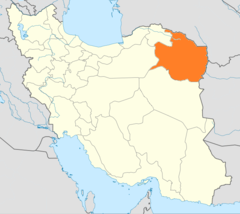
Położenie na mapie Iranu
| |
Chorasan-e Razawi – ostan w północno-wschodnim Iranie. Stolicą jest Meszhed.
- powierzchnia: 118 851,4 km²
- ludność: 5 994 402 (spis 2011)
Miasta
Przypisy
- ↑ a b c National Population and Housing Census 2011. The President’s Office Deputy of Strategic Planning and Control, Statistical Center of Iran, 2011. [dostęp 2016-06-20]. (ang.).
