
Plik:Hammurabi's Babylonia Locator Map 1.svg

Wielkość pliku podglądu PNG dla pliku SVG: 671 × 600 pikseli Inne rozdzielczości: 269 × 240 pikseli | 537 × 480 pikseli | 859 × 768 pikseli | 1146 × 1024 pikseli | 2291 × 2048 pikseli | 744 × 665 pikseli.
Rozmiar pierwotny (Plik SVG, nominalnie 744 × 665 pikseli, rozmiar pliku: 154 KB)
| Plik Hammurabi's Babylonia Locator Map 1.svg znajduje się w Wikimedia Commons – repozytorium wolnych zasobów. Dane z jego strony opisu znajdują się poniżej. |
Opis
| Opis |
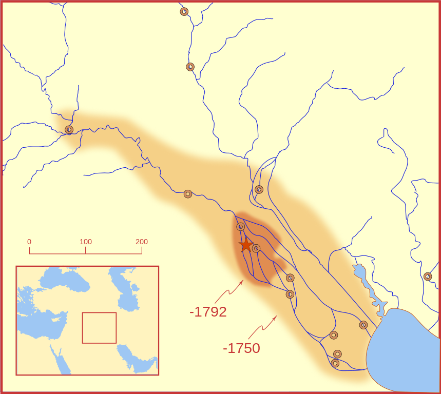
A locator map of Hammurabi's Babylonia, showing the Babylonian territory upon his ascension in 1792 BC and upon his death in 1750 BC. The river courses and coastline are those of that time period -- in general, they are not the modern rivers or coastlines. This is a Mercator projection, with north in its usual position. There is some question to what degree the cities of Nineveh, Tuttul, and Assur were under Babylonian authority. While in his introduction to his code of laws, Hammurabi claims lordship over these cities, Roaf does not include any of these in his map, upon which this map is based, and Chevalas states that "Assur and Nineveh were held for a very few years" (p. 155). Therefore, I have not included them as under Hammurabi's control in 1750 BC. |
| Data | |
| Źródło | Praca własna |
| Autor | MapMaster |
| Inne wersje |
[]
|


Other versions
References
- Bjorklund, Oddvar; Holmboe, Haakon; Rohr, Anders (1970) Historical Atlas of the World, Barnes & Noble, NY, SBN: 389-00253-4.
- Chavalas, Mark W.; K. Lawson Younger (2003) Mesopotamia and the Bible, Continuum International Publishing Group, ISBN 978-0567082312.
- Hammond World Atlas Corporation (2007) Historical World Atlas, ISBN 9-780843-71391-6
- Roaf, M. (1990) Cultural Atlas of Mesopotamia and the ancient Near East, Oxford: Facts on File. (In general, the basis for the ancient river courses and ancient coastline).
- Van De Mieroop, Marc (2005). King Hammurabi of Babylon: A Biography. Blackwell Publishing. ISBN 1405126604
Licencja
Ja, właściciel praw autorskich do tego dzieła, udostępniam je na poniższych licencjach

|
Udziela się zgody na kopiowanie, rozpowszechnianie oraz modyfikowanie tego dokumentu zgodnie z warunkami GNU Licencji Wolnej Dokumentacji, w wersji 1.2 lub nowszej opublikowanej przez Free Software Foundation; bez niezmiennych sekcji, bez treści umieszczonych na frontowej lub tylnej stronie okładki. Kopia licencji załączona jest w sekcji zatytułowanej GNU Licencja Wolnej Dokumentacji. |
This file is licensed under the Creative Commons Attribution-Share Alike Attribution-Share Alike 4.0 International, 3.0 Unported, 2.5 Generic, 2.0 Generic and 1.0 Generic license.
- Wolno:
- dzielić się – kopiować, rozpowszechniać, odtwarzać i wykonywać utwór
- modyfikować – tworzyć utwory zależne
- Na następujących warunkach:
- uznanie autorstwa – musisz określić autorstwo utworu, podać link do licencji, a także wskazać czy utwór został zmieniony. Możesz to zrobić w każdy rozsądny sposób, o ile nie będzie to sugerować, że licencjodawca popiera Ciebie lub Twoje użycie utworu.
- na tych samych warunkach – Jeśli zmienia się lub przekształca niniejszy utwór, lub tworzy inny na jego podstawie, można rozpowszechniać powstały w ten sposób nowy utwór tylko na podstawie tej samej lub podobnej licencji.
Możesz wybrać, którą licencję chcesz zastosować.
Historia pliku
Kliknij na datę/czas, aby zobaczyć, jak plik wyglądał w tym czasie.
| Data i czas | Miniatura | Wymiary | Użytkownik | Opis | |
|---|---|---|---|---|---|
| aktualny | 05:26, 21 lut 2008 | | 744 × 665 (154 KB) | MapMaster | "blurred" the territory outlines |
| 01:22, 21 lut 2008 |  | 744 × 665 (149 KB) | MapMaster | Changes based on a review of ''Mesopotamia and the Bible'' | |
| 00:10, 21 lut 2008 |  | 744 × 665 (151 KB) | MapMaster | Minor edits | |
| 05:03, 19 lut 2008 |  | 744 × 665 (150 KB) | MapMaster | Once more, with feeling | |
| 04:09, 19 lut 2008 |  | 744 × 665 (151 KB) | MapMaster | earlier upload would not render | |
| 04:01, 19 lut 2008 |  | 332 × 292 (333 KB) | MapMaster | {{Information |Description=A locator map of Hammurabi's Babylonia, showing the Babylonian territory upon his ascension in 1792 BC and upon his death in 1750 BC. The river courses and coastline are those of that time period -- in general, they are not the |
Lokalne wykorzystanie pliku
Poniższa strona korzysta z tego pliku:
Globalne wykorzystanie pliku
Ten plik jest wykorzystywany także w innych projektach wiki:
- Wykorzystanie na bg.wikipedia.org
- Wykorzystanie na bs.wikipedia.org
- Wykorzystanie na cs.wikipedia.org
- Wykorzystanie na da.wikipedia.org
- Wykorzystanie na el.wikipedia.org
- Wykorzystanie na eo.wikipedia.org
- Wykorzystanie na et.wikipedia.org
- Wykorzystanie na fi.wikipedia.org
- Wykorzystanie na fr.wikipedia.org
- Wykorzystanie na gl.wikipedia.org
- Wykorzystanie na he.wikipedia.org
- Wykorzystanie na hr.wikipedia.org
- Wykorzystanie na hu.wikipedia.org
- Wykorzystanie na id.wikipedia.org
- Wykorzystanie na it.wikipedia.org
- Wykorzystanie na ja.wikipedia.org
- Wykorzystanie na jv.wikipedia.org
- Wykorzystanie na lt.wikipedia.org
- Wykorzystanie na lv.wikipedia.org
- Wykorzystanie na nl.wikipedia.org
- Wykorzystanie na no.wikipedia.org
- Wykorzystanie na ro.wikipedia.org
- Wykorzystanie na ru.wikipedia.org
- Wykorzystanie na sh.wikipedia.org
- Wykorzystanie na sl.wikipedia.org
- Wykorzystanie na sq.wikipedia.org
- Wykorzystanie na sv.wikipedia.org
- Wykorzystanie na sw.wikipedia.org
- Wykorzystanie na tr.wikipedia.org